Property Record
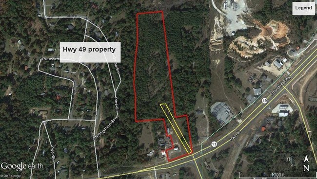
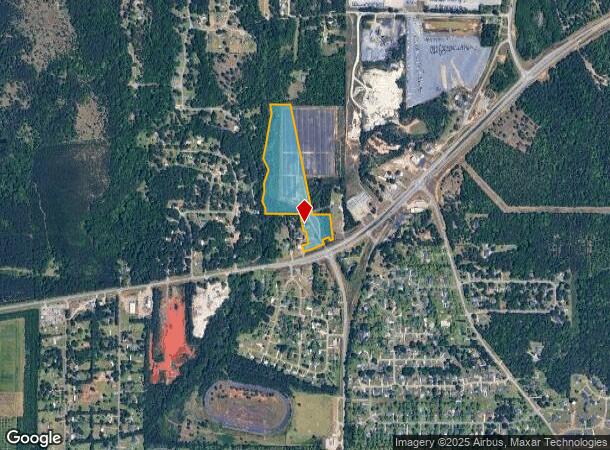
2415 N Ga Highway 49 N, Byron, GA 31008
NEARBY LISTINGS FOR SALE OR LEASE
Property Detail
2415 N Ga Highway 49 N
Warner Robins, GA
Hwy 49/Hwy 41
064B-009
18.343 AC LL76-77 LD5 PARCEL 1
Publicstorage
Peach
X
Georgia
13021C0240G
1
2025
18.34 AC
2025
Perry/Warner Robins
040103
Other Market Areas
1,800 SF
DEMOGRAPHICS near 2415 N Ga Highway 49 N
1 Mile
3 Mile
5 Mile
2024 Total Population
1,646
12,491
48,342
2029 Population
1,765
13,359
51,266
Pop Growth 2024-2029
+ 7.23%
+ 6.95%
+ 6.05%
Average Age
42
40
40
2024 Total Households
640
4,720
19,116
HH Growth 2024-2029
+ 7.19%
+ 6.72%
+ 5.98%
Median Household Inc
$55,666
$72,886
$60,950
Avg Household Size
2.50
2.60
2.50
2024 Avg HH Vehicles
2.00
2.00
2.00
Median Home Value
$127,475
$148,748
$153,766
Median Year Built
1987
1992
1991
Nearby Places
Map Layers
Map Styles
 Street
 Aerial
- Restaurants
- Banks
- Shops
- Fitness
- Groceries
SALE & LEASE HISTORY
LISTING DATE
SALE/LEASE

May 17, 2017
For Sale
Nearby Properties
Address
Land Use
TOTAL SIZE
Lot Size
Zoning
Address
Land Use
TOTAL SIZE
Lot Size
Zoning
11,088 SF
59.57 AC
M-2
Address
Land Use
TOTAL SIZE
Lot Size
Zoning
10,000 SF
1,163 AC
R-AG
Address
Land Use
TOTAL SIZE
Lot Size
Zoning
10,000 SF
43.93 AC
I-1
Address
Land Use
TOTAL SIZE
Lot Size
Zoning
2,116 SF
10.10 AC
C-1
Address
Land Use
TOTAL SIZE
Lot Size
Zoning
80,825 SF
7.20 AC
I-1
Address
Land Use
TOTAL SIZE
Lot Size
Zoning
100,000 SF
32.51 AC
M-2
Address
Land Use
TOTAL SIZE
Lot Size
Zoning
47,568 SF
1.51 AC
C-3
Address
Land Use
TOTAL SIZE
Lot Size
Zoning
42,056 SF
2.14 AC
C-3
Address
Land Use
TOTAL SIZE
Lot Size
Zoning
30,568 SF
7.44 AC
A
Address
Land Use
TOTAL SIZE
Lot Size
Zoning
102,163 SF
10.02 AC
M-1
Address
Land Use
TOTAL SIZE
Lot Size
Zoning
35,004 SF
1.45 AC
C-3
Address
Land Use
TOTAL SIZE
Lot Size
Zoning
152,300 SF
24.47 AC
M-1
Address
Land Use
TOTAL SIZE
Lot Size
Zoning
19,440 SF
28.87 AC
M-1
Address
Land Use
TOTAL SIZE
Lot Size
Zoning
200,100 SF
18.73 AC
M-2
Address
Land Use
TOTAL SIZE
Lot Size
Zoning
17,388 SF
7.02 AC
MULTI
Address
Land Use
TOTAL SIZE
Lot Size
Zoning
1,800 SF
33 AC
I-1
Address
Land Use
TOTAL SIZE
Lot Size
Zoning
24,400 SF
7 AC
MULTI
Address
Land Use
TOTAL SIZE
Lot Size
Zoning
26,131 SF
5.96 AC
C-1
Address
Land Use
TOTAL SIZE
Lot Size
Zoning
57,888 SF
1.01 AC
I-1
Address
Land Use
TOTAL SIZE
Lot Size
Zoning
104,627 SF
12.74 AC
M-1
Address
Land Use
TOTAL SIZE
Lot Size
Zoning
52,850 SF
22.73 AC
M-2
Address
Land Use
TOTAL SIZE
Lot Size
Zoning
54,175 SF
12.72 AC
C-3
Address
Land Use
TOTAL SIZE
Lot Size
Zoning
5,110 SF
2.03 AC
C-3
Address
Land Use
TOTAL SIZE
Lot Size
Zoning
7,680 SF
1.31 AC
C2
Address
Land Use
TOTAL SIZE
Lot Size
Zoning
35,784 SF
6.23 AC
C-3
Address
Land Use
TOTAL SIZE
Lot Size
Zoning
8,378 SF
7.20 AC
PDC
Address
Land Use
TOTAL SIZE
Lot Size
Zoning
62,100 SF
10 AC
M-2
Address
Land Use
TOTAL SIZE
Lot Size
Zoning
5,346 SF
2.13 AC
C-3
Address
Land Use
TOTAL SIZE
Lot Size
Zoning
151,980 SF
13.46 AC
M-1
Address
Land Use
TOTAL SIZE
Lot Size
Zoning
6,063 SF
3.77 AC
A/M-2
The World's #1 Commercial Real Estate Marketplace
Connect with us
© 2026 CoStar Group
The information above has been obtained from sources believed reliable. While we do not doubt its accuracy we have not verified it and make no guarantee, warranty or representation about it. It is your responsibility to independently confirm its accuracy and completeness. Any projections, opinions, assumptions, or estimates used are for example only and do not represent the current or future performance of the property. The value of this transaction to you depends on tax and other factors which should be evaluated by your tax, financial, and legal advisors. You and your advisors should conduct a careful, independent investigation of the property to determine to your satisfaction the suitability of the property for your needs.