Property Record
2415 Old Saint Augustine Rd, Tallahassee, FL 32301


NEARBY LISTINGS FOR SALE OR LEASE
Property Detail
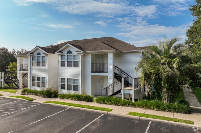
2415 Old Saint Augustine Rd
31-04-20-665-000.0
Unplatted Land
Multifamilydwelling
4 1S 1E IN SE 1/4 OF SW 1/4 DB 242/96 OR 119/454 OR 1030/2327 1477/513 OR 2235/541
X
Leon
12073C0311F
Florida
2025
11.19 AC
2025
Old Saint Augustine
000303
Tallahassee
184,361 SF
Tallahassee, FL
DEMOGRAPHICS near 2415 Old Saint Augustine Rd
1 Mile
3 Mile
5 Mile
2024 Total Population
11,320
55,252
133,716
2029 Population
12,075
58,620
140,901
Pop Growth 2024-2029
+ 6.67%
+ 6.10%
+ 5.37%
Average Age
34
36
36
2024 Total Households
5,557
25,060
58,049
HH Growth 2024-2029
+ 6.78%
+ 6.58%
+ 5.69%
Median Household Inc
$51,664
$60,152
$51,473
Avg Household Size
2.00
2.00
2.10
2024 Avg HH Vehicles
1.00
2.00
2.00
Median Home Value
$177,921
$228,446
$233,927
Median Year Built
1989
1988
1985
Nearby Places
Map Layers
Map Styles
 Street
 Aerial
- Restaurants
- Banks
- Shops
- Fitness
- Groceries
PUBLIC TRANSPORTATION
AIRPORT
Tallahassee International
DRIVE
WALK
Distance
Tallahassee International
19 min
9.2 mi
Freight Ports
Port of Panama City
DRIVE
WALK
Distance
Port of Panama City
152 min
105.2 mi
Nearby Properties
Address
Land Use
TOTAL SIZE
Lot Size
Zoning
Address
Land Use
TOTAL SIZE
Lot Size
Zoning
3,882,850 SF
22.64 AC
CM
Address
Land Use
TOTAL SIZE
Lot Size
Zoning
2,322,139 SF
194.32 AC
PUD
Address
Land Use
TOTAL SIZE
Lot Size
Zoning
2,330,342 SF
69.26 AC
UT
Address
Land Use
TOTAL SIZE
Lot Size
Zoning
807,298 SF
145.81 AC
UT
Address
Land Use
TOTAL SIZE
Lot Size
Zoning
2,312,757 SF
10.87 AC
CCPD
Address
Land Use
TOTAL SIZE
Lot Size
Zoning
718,575 SF
47.84 AC
PUD
Address
Land Use
TOTAL SIZE
Lot Size
Zoning
806,710 SF
2.96 AC
CCPD
Address
Land Use
TOTAL SIZE
Lot Size
Zoning
602,388 SF
34.48 AC
Address
Land Use
TOTAL SIZE
Lot Size
Zoning
577,345 SF
30.63 AC
Address
Land Use
TOTAL SIZE
Lot Size
Zoning
899,528 SF
3.34 AC
CCPD
Address
Land Use
TOTAL SIZE
Lot Size
Zoning
846,072 SF
166.39 AC
R1
Address
Land Use
TOTAL SIZE
Lot Size
Zoning
200,705 SF
31.57 AC
Address
Land Use
TOTAL SIZE
Lot Size
Zoning
756,595 SF
18.35 AC
Address
Land Use
TOTAL SIZE
Lot Size
Zoning
428,190 SF
2.24 AC
CCPD
Address
Land Use
TOTAL SIZE
Lot Size
Zoning
756,294 SF
20.19 AC
OR3
Address
Land Use
TOTAL SIZE
Lot Size
Zoning
249,612 SF
1.67 AC
CCPD
Address
Land Use
TOTAL SIZE
Lot Size
Zoning
494,919 SF
20.12 AC
R4
Address
Land Use
TOTAL SIZE
Lot Size
Zoning
456,149 SF
22.50 AC
OR3
Address
Land Use
TOTAL SIZE
Lot Size
Zoning
498,616 SF
2.03 AC
CCPD
Address
Land Use
TOTAL SIZE
Lot Size
Zoning
280,000 SF
1.55 AC
CCPD
Address
Land Use
TOTAL SIZE
Lot Size
Zoning
651,095 SF
23.51 AC
UT
Address
Land Use
TOTAL SIZE
Lot Size
Zoning
367,539 SF
26.23 AC
CPA
Address
Land Use
TOTAL SIZE
Lot Size
Zoning
220,000 SF
2.50 AC
CCPD
Address
Land Use
TOTAL SIZE
Lot Size
Zoning
227,485 SF
2.43 AC
Address
Land Use
TOTAL SIZE
Lot Size
Zoning
708,504 SF
50.44 AC
PUD
Address
Land Use
TOTAL SIZE
Lot Size
Zoning
380,000 SF
21.78 AC
PUD
Address
Land Use
TOTAL SIZE
Lot Size
Zoning
399,048 SF
19.43 AC
PUD
Address
Land Use
TOTAL SIZE
Lot Size
Zoning
169,758 SF
1.71 AC
RO
Address
Land Use
TOTAL SIZE
Lot Size
Zoning
376,746 SF
12.92 AC
OR2
Address
Land Use
TOTAL SIZE
Lot Size
Zoning
473,339 SF
51.93 AC
PUD
The World's #1 Commercial Real Estate Marketplace
Connect with us
© 2025 CoStar Group
The information above has been obtained from sources believed reliable. While we do not doubt its accuracy we have not verified it and make no guarantee, warranty or representation about it. It is your responsibility to independently confirm its accuracy and completeness. Any projections, opinions, assumptions, or estimates used are for example only and do not represent the current or future performance of the property. The value of this transaction to you depends on tax and other factors which should be evaluated by your tax, financial, and legal advisors. You and your advisors should conduct a careful, independent investigation of the property to determine to your satisfaction the suitability of the property for your needs.