Property Record
2415 State Barn Rd, Cumming, GA 30040
NEARBY LISTINGS FOR SALE OR LEASE
-
-
View all Cumming listings for lease on LoopNet.com
Property Detail
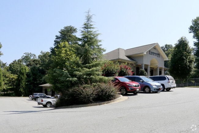
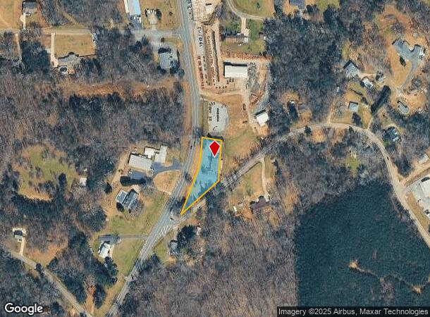
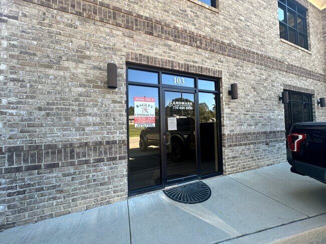
2415 State Barn Rd
Atlanta-Sandy Springs-Roswell, GA
Coal Mountain
192-100
3-1 757-758
Officebuilding
Forsyth
X
Georgia
13117C0065G
757
2024
0.73 AC
2025
N Fulton/Forsyth County
130205
Atlanta
904 SF
DEMOGRAPHICS near 2415 State Barn Rd
1 Mile
3 Mile
5 Mile
2024 Total Population
4,027
25,340
68,765
2029 Population
4,669
29,454
80,450
Pop Growth 2024-2029
+ 15.94%
+ 16.24%
+ 16.99%
Average Age
35
39
40
2024 Total Households
1,284
8,894
23,994
HH Growth 2024-2029
+ 16.04%
+ 16.35%
+ 17.08%
Median Household Inc
$104,679
$98,722
$99,981
Avg Household Size
3.10
2.80
2.80
2024 Avg HH Vehicles
2.00
2.00
2.00
Median Home Value
$337,005
$368,718
$382,682
Median Year Built
2006
2000
2000
Nearby Places
Map Layers
Map Styles
 Street
 Aerial
- Restaurants
- Banks
- Shops
- Fitness
- Groceries
SALE & LEASE HISTORY
LISTING DATE
SALE/LEASE

Sep 23, 2019
For Lease
Mar 01, 2021
For Lease
Dec 15, 2021
For Lease
Aug 20, 2020
For Lease
Aug 16, 2024
For Lease
Apr 01, 2020
For Lease
Nearby Properties
Address
Land Use
TOTAL SIZE
Lot Size
Zoning
Address
Land Use
TOTAL SIZE
Lot Size
Zoning
305,332 SF
23.75 AC
CBD
Address
Land Use
TOTAL SIZE
Lot Size
Zoning
62,085 SF
28.70 AC
INST
Address
Land Use
TOTAL SIZE
Lot Size
Zoning
413,484 SF
127.99 AC
A1
Address
Land Use
TOTAL SIZE
Lot Size
Zoning
159,291 SF
29.19 AC
MU
Address
Land Use
TOTAL SIZE
Lot Size
Zoning
98,743 SF
12.61 AC
CBD
Address
Land Use
TOTAL SIZE
Lot Size
Zoning
19.21 AC
M1
Address
Land Use
TOTAL SIZE
Lot Size
Zoning
152,668 SF
41.92 AC
CBD
Address
Land Use
TOTAL SIZE
Lot Size
Zoning
74,796 SF
9.92 AC
CBD
Address
Land Use
TOTAL SIZE
Lot Size
Zoning
68,188 SF
121.31 AC
A1
Address
Land Use
TOTAL SIZE
Lot Size
Zoning
192,550 SF
21.11 AC
CBD
Address
Land Use
TOTAL SIZE
Lot Size
Zoning
17,657 SF
59.25 AC
A1
Address
Land Use
TOTAL SIZE
Lot Size
Zoning
151,580 SF
21.78 AC
MU
Address
Land Use
TOTAL SIZE
Lot Size
Zoning
80,956 SF
6.07 AC
CBD
Address
Land Use
TOTAL SIZE
Lot Size
Zoning
114,998 SF
13.09 AC
INST
Address
Land Use
TOTAL SIZE
Lot Size
Zoning
2,750 SF
276.79 AC
A1
Address
Land Use
TOTAL SIZE
Lot Size
Zoning
80,497 SF
9.22 AC
CBD
Address
Land Use
TOTAL SIZE
Lot Size
Zoning
8,235 SF
5.65 AC
CBD
Address
Land Use
TOTAL SIZE
Lot Size
Zoning
12,217 SF
3.85 AC
CBD
Address
Land Use
TOTAL SIZE
Lot Size
Zoning
42,564 SF
10.69 AC
INST
Address
Land Use
TOTAL SIZE
Lot Size
Zoning
102,962 SF
20 AC
LR
Address
Land Use
TOTAL SIZE
Lot Size
Zoning
54,186 SF
26.64 AC
CBD
Address
Land Use
TOTAL SIZE
Lot Size
Zoning
69,200 SF
5.61 AC
CBD
Address
Land Use
TOTAL SIZE
Lot Size
Zoning
42.36 AC
CBD
Address
Land Use
TOTAL SIZE
Lot Size
Zoning
2,955 SF
5.88 AC
NS
Address
Land Use
TOTAL SIZE
Lot Size
Zoning
138.66 AC
A1
Address
Land Use
TOTAL SIZE
Lot Size
Zoning
56,550 SF
16.80 AC
M1
Address
Land Use
TOTAL SIZE
Lot Size
Zoning
17.54 AC
R1
Address
Land Use
TOTAL SIZE
Lot Size
Zoning
40,092 SF
3.35 AC
M1
Address
Land Use
TOTAL SIZE
Lot Size
Zoning
1,595 SF
16.76 AC
CBD
Address
Land Use
TOTAL SIZE
Lot Size
Zoning
41,486 SF
6.11 AC
M1
The World's #1 Commercial Real Estate Marketplace
Connect with us
© 2025 CoStar Group
The information above has been obtained from sources believed reliable. While we do not doubt its accuracy we have not verified it and make no guarantee, warranty or representation about it. It is your responsibility to independently confirm its accuracy and completeness. Any projections, opinions, assumptions, or estimates used are for example only and do not represent the current or future performance of the property. The value of this transaction to you depends on tax and other factors which should be evaluated by your tax, financial, and legal advisors. You and your advisors should conduct a careful, independent investigation of the property to determine to your satisfaction the suitability of the property for your needs.