Property Record
2415 W Ripple Ave, Oshkosh, WI 54904

This Property Is For Sale
NEARBY LISTINGS FOR SALE OR LEASE
Property Detail
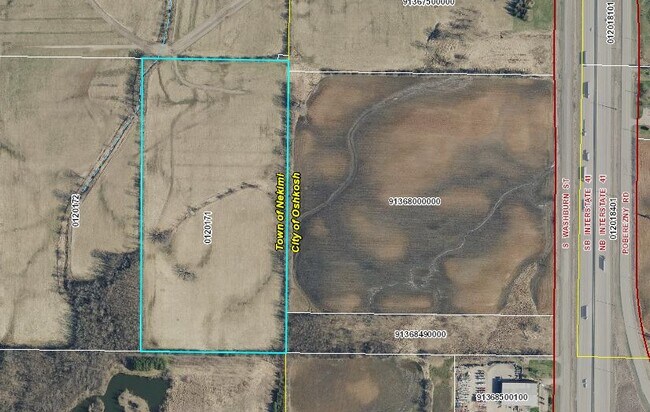
2415 W Ripple Ave
012-0171
E1/2 NW SE 20.00 A.
Agriculturalland
Winnebago
X
Wisconsin
55039C0100F
20 AC
2024
Appleton/Oshkosh
2024
Other Market Areas
001900
Oshkosh-Neenah, WI
DEMOGRAPHICS near 2415 W Ripple Ave
1 Mile
3 Mile
5 Mile
2024 Total Population
71
3,762
36,842
2029 Population
72
3,773
37,177
Pop Growth 2024-2029
+ 1.41%
+ 0.29%
+ 0.91%
Average Age
46
45
41
2024 Total Households
34
1,713
16,944
HH Growth 2024-2029
0.00%
+ 0.12%
+ 0.96%
Median Household Inc
$79,687
$76,732
$59,781
Avg Household Size
2.00
2.20
2.10
2024 Avg HH Vehicles
2.00
2.00
2.00
Median Home Value
$237,500
$211,306
$174,620
Median Year Built
1993
1986
1979
Nearby Places
Map Layers
Map Styles
 Street
 Aerial
- Restaurants
- Banks
- Shops
- Fitness
- Groceries
PUBLIC TRANSPORTATION
AIRPORT
Appleton International
DRIVE
WALK
Distance
Appleton International
37 min
27.2 mi
Freight Ports
Port Milwaukee
DRIVE
WALK
Distance
Port Milwaukee
102 min
84.1 mi
Nearby Properties
Address
Land Use
TOTAL SIZE
Lot Size
Zoning
Address
Land Use
TOTAL SIZE
Lot Size
Zoning
931,304 SF
107 AC
M3
Address
Land Use
TOTAL SIZE
Lot Size
Zoning
15.37 AC
SMU-PD
Address
Land Use
TOTAL SIZE
Lot Size
Zoning
570,585 SF
81.26 AC
M2
Address
Land Use
TOTAL SIZE
Lot Size
Zoning
18.38 AC
UIPD
Address
Land Use
TOTAL SIZE
Lot Size
Zoning
41.70 AC
HI
Address
Land Use
TOTAL SIZE
Lot Size
Zoning
110,200 SF
14.77 AC
MR-12-PD
Address
Land Use
TOTAL SIZE
Lot Size
Zoning
238,238 SF
22.60 AC
M3
Address
Land Use
TOTAL SIZE
Lot Size
Zoning
19,488 SF
16.43 AC
C-2
Address
Land Use
TOTAL SIZE
Lot Size
Zoning
271,088 SF
36.80 AC
M3
Address
Land Use
TOTAL SIZE
Lot Size
Zoning
341,904 SF
40.71 AC
HI
Address
Land Use
TOTAL SIZE
Lot Size
Zoning
107,778 SF
8.57 AC
SMUPD
Address
Land Use
TOTAL SIZE
Lot Size
Zoning
92,958 SF
1.02 AC
C2
Address
Land Use
TOTAL SIZE
Lot Size
Zoning
114,338 SF
10.20 AC
C2
Address
Land Use
TOTAL SIZE
Lot Size
Zoning
58,465 SF
43.67 AC
M3
Address
Land Use
TOTAL SIZE
Lot Size
Zoning
32,430 SF
7.44 AC
M1
Address
Land Use
TOTAL SIZE
Lot Size
Zoning
28,512 SF
6.20 AC
M1
Address
Land Use
TOTAL SIZE
Lot Size
Zoning
42,092 SF
3.21 AC
C2
Address
Land Use
TOTAL SIZE
Lot Size
Zoning
126,814 SF
22.60 AC
HI
Address
Land Use
TOTAL SIZE
Lot Size
Zoning
210,000 SF
10.02 AC
M3
Address
Land Use
TOTAL SIZE
Lot Size
Zoning
62,880 SF
5.78 AC
M3
Address
Land Use
TOTAL SIZE
Lot Size
Zoning
66,456 SF
5.91 AC
MR-12-PD
Address
Land Use
TOTAL SIZE
Lot Size
Zoning
38,858 SF
8.15 AC
M1
Address
Land Use
TOTAL SIZE
Lot Size
Zoning
115,624 SF
14.41 AC
M3
Address
Land Use
TOTAL SIZE
Lot Size
Zoning
13.67 AC
Address
Land Use
TOTAL SIZE
Lot Size
Zoning
47,932 SF
4.95 AC
C2
Address
Land Use
TOTAL SIZE
Lot Size
Zoning
47,856 SF
5.26 AC
SMU-PD
Address
Land Use
TOTAL SIZE
Lot Size
Zoning
13.75 AC
Address
Land Use
TOTAL SIZE
Lot Size
Zoning
16.34 AC
Address
Land Use
TOTAL SIZE
Lot Size
Zoning
20,544 SF
4.16 AC
M-1PD
Address
Land Use
TOTAL SIZE
Lot Size
Zoning
67,734 SF
5.62 AC
MR-12-PD
The World's #1 Commercial Real Estate Marketplace
Connect with us
© 2025 CoStar Group
The information above has been obtained from sources believed reliable. While we do not doubt its accuracy we have not verified it and make no guarantee, warranty or representation about it. It is your responsibility to independently confirm its accuracy and completeness. Any projections, opinions, assumptions, or estimates used are for example only and do not represent the current or future performance of the property. The value of this transaction to you depends on tax and other factors which should be evaluated by your tax, financial, and legal advisors. You and your advisors should conduct a careful, independent investigation of the property to determine to your satisfaction the suitability of the property for your needs.