Property Record
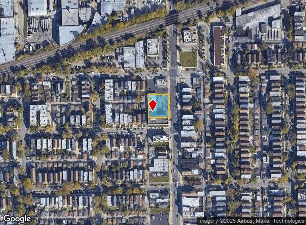
2416 S Pulaski Rd, Chicago, IL 60623
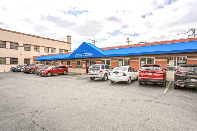

This Property Is For Sale
NEARBY LISTINGS FOR SALE OR LEASE
Property Detail
2416 S Pulaski Rd
16-27-218-021-0000
Edward
Commercialbuilding
Cook
X
Illinois
17031C0505J
16,20
2023
0.35 AC
2024
South Chicago
301802
Chicago
6,214 SF
Chicago-Naperville-Elgin, IL-IN-WI
DEMOGRAPHICS near 2416 S Pulaski Rd
1 Mile
3 Mile
5 Mile
2024 Total Population
45,226
271,806
829,287
2029 Population
39,938
247,295
771,968
Pop Growth 2024-2029
(11.69%)
(9.02%)
(6.91%)
Average Age
36
37
37
2024 Total Households
13,803
86,044
299,055
HH Growth 2024-2029
(12.27%)
(9.73%)
(7.03%)
Median Household Inc
$38,242
$44,386
$61,526
Avg Household Size
3.10
2.90
2.60
2024 Avg HH Vehicles
1.00
1.00
1.00
Median Home Value
$190,803
$225,908
$281,042
Median Year Built
1947
1947
1948
Nearby Places
- Restaurants
- Banks
- Shops
- Fitness
- Groceries
PUBLIC TRANSPORTATION
TRANSIT/SUBWAY
Pulaski Station (Pink Line) (Pink Line - Chicago Transit Authority "L" Trains (The "L"))
DRIVE
WALK
Distance
Pulaski Station (Pink Line) (Pink Line - Chicago Transit Authority "L" Trains (The "L"))
1 min
10 min
0.5 mi
Central Park Station (Pink Line - Chicago Transit Authority "L" Trains (The "L"))
DRIVE
WALK
Distance
Central Park Station (Pink Line - Chicago Transit Authority "L" Trains (The "L"))
2 min
16 min
0.8 mi
Kostner Station (Pink Line - Chicago Transit Authority "L" Trains (The "L"))
DRIVE
WALK
Distance
Kostner Station (Pink Line - Chicago Transit Authority "L" Trains (The "L"))
3 min
17 min
0.9 mi
COMMUTER RAIL
Cicero Station (Burlington Northern-Santa Fe Railway Line - Northeast Illinois Regional Commuter Railroad (Metra))
DRIVE
WALK
Distance
Cicero Station (Burlington Northern-Santa Fe Railway Line - Northeast Illinois Regional Commuter Railroad (Metra))
3 min
1.6 mi
Western Avenue Station (BNSF) (Burlington Northern-Santa Fe Railway Line - Northeast Illinois Regional Commuter Railroad (Metra))
DRIVE
WALK
Distance
Western Avenue Station (BNSF) (Burlington Northern-Santa Fe Railway Line - Northeast Illinois Regional Commuter Railroad (Metra))
6 min
2.7 mi
AIRPORT
Chicago Midway International
DRIVE
WALK
Distance
Chicago Midway International
10 min
5.0 mi
Chicago O'Hare International
DRIVE
WALK
Distance
Chicago O'Hare International
31 min
17.6 mi
Nearby Properties
Address
Land Use
TOTAL SIZE
Lot Size
Zoning
Address
Land Use
TOTAL SIZE
Lot Size
Zoning
73,700 SF
0.48 AC
RM-6.5
Address
Land Use
TOTAL SIZE
Lot Size
Zoning
474,979 SF
29.67 AC
PD 553
Address
Land Use
TOTAL SIZE
Lot Size
Zoning
86,928 SF
4.80 AC
PD 933
Address
Land Use
TOTAL SIZE
Lot Size
Zoning
1,313,541 SF
44.90 AC
M2-2
Address
Land Use
TOTAL SIZE
Lot Size
Zoning
604,145 SF
28.21 AC
Address
Land Use
TOTAL SIZE
Lot Size
Zoning
4.85 AC
PD 1505
Address
Land Use
TOTAL SIZE
Lot Size
Zoning
1,220,173 SF
26.53 AC
M2-2
Address
Land Use
TOTAL SIZE
Lot Size
Zoning
27.31 AC
PD 1424
Address
Land Use
TOTAL SIZE
Lot Size
Zoning
133,354 SF
PD 1198
Address
Land Use
TOTAL SIZE
Lot Size
Zoning
290,798 SF
23.70 AC
Address
Land Use
TOTAL SIZE
Lot Size
Zoning
32,500 SF
0.56 AC
RT-4
Address
Land Use
TOTAL SIZE
Lot Size
Zoning
307,277 SF
9.90 AC
PMD 11
Address
Land Use
TOTAL SIZE
Lot Size
Zoning
0.58 AC
B3-2
Address
Land Use
TOTAL SIZE
Lot Size
Zoning
1.97 AC
PD 30
Address
Land Use
TOTAL SIZE
Lot Size
Zoning
4.83 AC
Address
Land Use
TOTAL SIZE
Lot Size
Zoning
291,681 SF
14.04 AC
Address
Land Use
TOTAL SIZE
Lot Size
Zoning
549,955 SF
18.01 AC
Address
Land Use
TOTAL SIZE
Lot Size
Zoning
72,893 SF
4.43 AC
PD 90
Address
Land Use
TOTAL SIZE
Lot Size
Zoning
578,024 SF
31.94 AC
Address
Land Use
TOTAL SIZE
Lot Size
Zoning
93,409 SF
2.05 AC
PD 146
Address
Land Use
TOTAL SIZE
Lot Size
Zoning
189,197 SF
23.08 AC
Address
Land Use
TOTAL SIZE
Lot Size
Zoning
1,023,467 SF
21.45 AC
PD 1424
Address
Land Use
TOTAL SIZE
Lot Size
Zoning
1,107,999 SF
119.41 AC
Address
Land Use
TOTAL SIZE
Lot Size
Zoning
7.68 AC
Address
Land Use
TOTAL SIZE
Lot Size
Zoning
131,261 SF
7.04 AC
PD 172
Address
Land Use
TOTAL SIZE
Lot Size
Zoning
310,775 SF
12.46 AC
M2-3
Address
Land Use
TOTAL SIZE
Lot Size
Zoning
43,800 SF
0.94 AC
M1-2
Address
Land Use
TOTAL SIZE
Lot Size
Zoning
0.41 AC
RT-4
Address
Land Use
TOTAL SIZE
Lot Size
Zoning
160,487 SF
3.06 AC
PMD 11
Address
Land Use
TOTAL SIZE
Lot Size
Zoning
15.25 AC
The World's #1 Commercial Real Estate Marketplace
Connect with us
© 2025 CoStar Group
The information above has been obtained from sources believed reliable. While we do not doubt its accuracy we have not verified it and make no guarantee, warranty or representation about it. It is your responsibility to independently confirm its accuracy and completeness. Any projections, opinions, assumptions, or estimates used are for example only and do not represent the current or future performance of the property. The value of this transaction to you depends on tax and other factors which should be evaluated by your tax, financial, and legal advisors. You and your advisors should conduct a careful, independent investigation of the property to determine to your satisfaction the suitability of the property for your needs.