Property Record
2416 Sloat Way, Sacramento, CA 95818
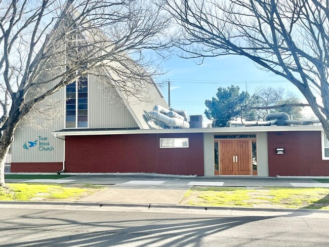


This Property Is For Sale
NEARBY LISTINGS FOR SALE OR LEASE
Property Detail
2416 Sloat Way
Sacramento--Roseville--Arden-Arcade, CA
Highland Park Add
010-0351-022
LOTS 4, 5, & 6, HIGHLAND PARK ADDITON TO SACRAMENTO & ALSOTHAT POR. OF LOT 7 DESC. AS: BEG. AT THE NE COR. OF SD. LOT7; TH.
Religious
Sacramento
X
California
06067C0190H
4,5,7
2024
0.40 AC
2025
South Sacramento
002600
Sacramento
4,710 SF
DEMOGRAPHICS near 2416 Sloat Way
1 Mile
3 Mile
5 Mile
2024 Total Population
24,472
166,374
411,151
2029 Population
24,787
168,552
415,537
Pop Growth 2024-2029
+ 1.29%
+ 1.31%
+ 1.07%
Average Age
40
39
38
2024 Total Households
11,965
71,847
160,455
HH Growth 2024-2029
+ 1.41%
+ 1.51%
+ 1.20%
Median Household Inc
$84,714
$77,780
$68,481
Avg Household Size
1.90
2.10
2.40
2024 Avg HH Vehicles
1.00
2.00
2.00
Median Home Value
$695,335
$615,552
$467,001
Median Year Built
1949
1955
1968
Nearby Places
Map Layers
Map Styles
 Street
 Aerial
- Restaurants
- Banks
- Shops
- Fitness
- Groceries
PUBLIC TRANSPORTATION
TRANSIT/SUBWAY
Broadway (Blue Line - Sacramento Regional Transit District Light Rail (The RT))
DRIVE
WALK
Distance
Broadway (Blue Line - Sacramento Regional Transit District Light Rail (The RT))
2 min
12 min
0.6 mi
4th Ave./Wayne Hultgren (Blue Line - Sacramento Regional Transit District Light Rail (The RT))
DRIVE
WALK
Distance
4th Ave./Wayne Hultgren (Blue Line - Sacramento Regional Transit District Light Rail (The RT))
2 min
13 min
0.7 mi
23rd Street (Gold Line - Sacramento Regional Transit District Light Rail (The RT))
DRIVE
WALK
Distance
23rd Street (Gold Line - Sacramento Regional Transit District Light Rail (The RT))
4 min
17 min
0.9 mi
COMMUTER RAIL
DRIVE
WALK
Distance
7 min
3.1 mi
AIRPORT
Sacramento International
DRIVE
WALK
Distance
Sacramento International
22 min
14.0 mi
Freight Ports
Port of Stockton
DRIVE
WALK
Distance
Port of Stockton
56 min
46.0 mi
Nearby Properties
Address
Land Use
TOTAL SIZE
Lot Size
Zoning
Address
Land Use
TOTAL SIZE
Lot Size
Zoning
1,095,507 SF
1.39 AC
H-SPD C-2-
Address
Land Use
TOTAL SIZE
Lot Size
Zoning
5.64 AC
C-3-SPD
Address
Land Use
TOTAL SIZE
Lot Size
Zoning
10.28 AC
H
Address
Land Use
TOTAL SIZE
Lot Size
Zoning
299,943 SF
4.95 AC
H
Address
Land Use
TOTAL SIZE
Lot Size
Zoning
487,483 SF
1.12 AC
C-3-SPD
Address
Land Use
TOTAL SIZE
Lot Size
Zoning
1.33 AC
R-1
Address
Land Use
TOTAL SIZE
Lot Size
Zoning
756,831 SF
1.39 AC
C-2-SPD
Address
Land Use
TOTAL SIZE
Lot Size
Zoning
399,626 SF
2.41 AC
C-3-SPD
Address
Land Use
TOTAL SIZE
Lot Size
Zoning
1.15 AC
R-1
Address
Land Use
TOTAL SIZE
Lot Size
Zoning
366,730 SF
0.89 AC
C-3-SPD
Address
Land Use
TOTAL SIZE
Lot Size
Zoning
200,616 SF
2.54 AC
C-2-SPD
Address
Land Use
TOTAL SIZE
Lot Size
Zoning
594,942 SF
2.39 AC
C-3-SPD
Address
Land Use
TOTAL SIZE
Lot Size
Zoning
676,447 SF
1.43 AC
C-3-SPD
Address
Land Use
TOTAL SIZE
Lot Size
Zoning
193,521 SF
0.60 AC
C-3-SPD
Address
Land Use
TOTAL SIZE
Lot Size
Zoning
339,329 SF
6.40 AC
R-5-PUD-SP
Address
Land Use
TOTAL SIZE
Lot Size
Zoning
213,557 SF
2.33 AC
C-3-SPD
Address
Land Use
TOTAL SIZE
Lot Size
Zoning
0.65 AC
C-4-SPD
Address
Land Use
TOTAL SIZE
Lot Size
Zoning
467,970 SF
4.59 AC
W-F
Address
Land Use
TOTAL SIZE
Lot Size
Zoning
410,420 SF
0.95 AC
C-3-SPD
Address
Land Use
TOTAL SIZE
Lot Size
Zoning
320,072 SF
2.65 AC
C-2
Address
Land Use
TOTAL SIZE
Lot Size
Zoning
R-4-PUD C-
Address
Land Use
TOTAL SIZE
Lot Size
Zoning
0.13 AC
WF
Address
Land Use
TOTAL SIZE
Lot Size
Zoning
26,712 SF
1.90 AC
R-5-PUD-SP
Address
Land Use
TOTAL SIZE
Lot Size
Zoning
26,712 SF
1.85 AC
R-5-PUD-SP
Address
Land Use
TOTAL SIZE
Lot Size
Zoning
2.88 AC
C-3-SPD
Address
Land Use
TOTAL SIZE
Lot Size
Zoning
508,916 SF
0.71 AC
C-3-SPD
Address
Land Use
TOTAL SIZE
Lot Size
Zoning
246,417 SF
1.19 AC
C-3-SPD
Address
Land Use
TOTAL SIZE
Lot Size
Zoning
405,074 SF
2.39 AC
C-3-SPD
Address
Land Use
TOTAL SIZE
Lot Size
Zoning
119,055 SF
1.18 AC
C-2-SPD
Address
Land Use
TOTAL SIZE
Lot Size
Zoning
383,000 SF
25.52 AC
M-1
The World's #1 Commercial Real Estate Marketplace
Connect with us
© 2026 CoStar Group
The information above has been obtained from sources believed reliable. While we do not doubt its accuracy we have not verified it and make no guarantee, warranty or representation about it. It is your responsibility to independently confirm its accuracy and completeness. Any projections, opinions, assumptions, or estimates used are for example only and do not represent the current or future performance of the property. The value of this transaction to you depends on tax and other factors which should be evaluated by your tax, financial, and legal advisors. You and your advisors should conduct a careful, independent investigation of the property to determine to your satisfaction the suitability of the property for your needs.