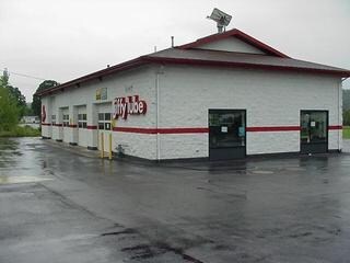
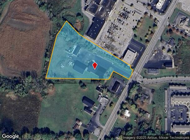
Property Record
2416 State Route 19 N, Warsaw, NY 14569
NEARBY LISTINGS FOR SALE OR LEASE
-
-
View all Warsaw listings for sale on LoopNet.com
Property Detail
2416 State Route 19 N
564889-061-000-0002-050-211-0000
Wyoming
Manufacturinglight
New York
2025
50.211
2024
5 AC
970500
Other Market Areas
23,520 SF
DEMOGRAPHICS near 2416 State Route 19 N
1 Mile
3 Mile
5 Mile
2024 Total Population
585
4,917
7,071
2029 Population
579
4,873
6,995
Pop Growth 2024-2029
(1.03%)
(0.89%)
(1.07%)
Average Age
45
44
44
2024 Total Households
246
2,118
2,904
HH Growth 2024-2029
(1.22%)
(0.90%)
(1.03%)
Median Household Inc
$46,785
$47,192
$53,564
Avg Household Size
2.20
2.20
2.20
2024 Avg HH Vehicles
1.00
1.00
2.00
Median Home Value
$141,176
$139,909
$142,243
Median Year Built
1955
1948
1949
Nearby Places
- Restaurants
- Banks
- Shops
- Fitness
- Groceries
Nearby Properties
Address
Land Use
TOTAL SIZE
Lot Size
Zoning
Address
Land Use
TOTAL SIZE
Lot Size
Zoning
34,085 SF
17.24 AC
02 - SINGL
Address
Land Use
TOTAL SIZE
Lot Size
Zoning
127,224 SF
7.90 AC
Address
Land Use
TOTAL SIZE
Lot Size
Zoning
110,100 SF
13.93 AC
02 - SINGL
Address
Land Use
TOTAL SIZE
Lot Size
Zoning
Address
Land Use
TOTAL SIZE
Lot Size
Zoning
75,167 SF
27.31 AC
05 - COMME
Address
Land Use
TOTAL SIZE
Lot Size
Zoning
31,057 SF
2.37 AC
05 - COMME
Address
Land Use
TOTAL SIZE
Lot Size
Zoning
Address
Land Use
TOTAL SIZE
Lot Size
Zoning
41,904 SF
0.08 AC
02 - SINGL
Address
Land Use
TOTAL SIZE
Lot Size
Zoning
89,362 SF
7.33 AC
02 - SINGL
Address
Land Use
TOTAL SIZE
Lot Size
Zoning
31,450 SF
2.44 AC
02 - SINGL
Address
Land Use
TOTAL SIZE
Lot Size
Zoning
Address
Land Use
TOTAL SIZE
Lot Size
Zoning
45,533 SF
15.29 AC
05 - COMME
Address
Land Use
TOTAL SIZE
Lot Size
Zoning
Address
Land Use
TOTAL SIZE
Lot Size
Zoning
Address
Land Use
TOTAL SIZE
Lot Size
Zoning
Address
Land Use
TOTAL SIZE
Lot Size
Zoning
Address
Land Use
TOTAL SIZE
Lot Size
Zoning
Address
Land Use
TOTAL SIZE
Lot Size
Zoning
Address
Land Use
TOTAL SIZE
Lot Size
Zoning
Address
Land Use
TOTAL SIZE
Lot Size
Zoning
Address
Land Use
TOTAL SIZE
Lot Size
Zoning
Address
Land Use
TOTAL SIZE
Lot Size
Zoning
Address
Land Use
TOTAL SIZE
Lot Size
Zoning
Address
Land Use
TOTAL SIZE
Lot Size
Zoning
Address
Land Use
TOTAL SIZE
Lot Size
Zoning
Address
Land Use
TOTAL SIZE
Lot Size
Zoning
Address
Land Use
TOTAL SIZE
Lot Size
Zoning
Address
Land Use
TOTAL SIZE
Lot Size
Zoning
Address
Land Use
TOTAL SIZE
Lot Size
Zoning
Address
Land Use
TOTAL SIZE
Lot Size
Zoning
The World's #1 Commercial Real Estate Marketplace
Connect with us
© 2025 CoStar Group
The information above has been obtained from sources believed reliable. While we do not doubt its accuracy we have not verified it and make no guarantee, warranty or representation about it. It is your responsibility to independently confirm its accuracy and completeness. Any projections, opinions, assumptions, or estimates used are for example only and do not represent the current or future performance of the property. The value of this transaction to you depends on tax and other factors which should be evaluated by your tax, financial, and legal advisors. You and your advisors should conduct a careful, independent investigation of the property to determine to your satisfaction the suitability of the property for your needs.