No Photo
Property Record
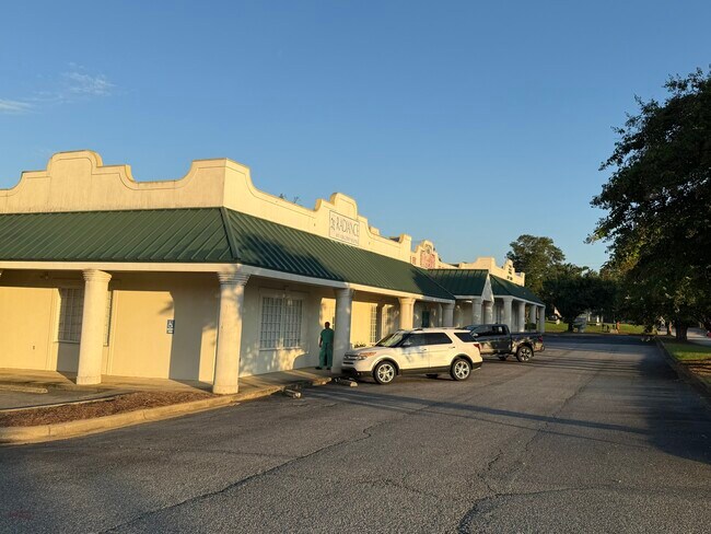
2416 Westgate Dr, Albany, GA 31707
This Property Is For Sale
NEARBY LISTINGS FOR SALE OR LEASE
Property Detail
2416 Westgate Dr
Albany, GA
Lake Park Complex
00303-00008-01I
LOT 1A(RESUB LOT 1)ROSENBERG
Medicalbuilding
Dougherty
X
Georgia
13095C0105E
1
2024
0.20 AC
2024
Albany/Southwest
000502
Other Market Areas
2,436 SF
DEMOGRAPHICS near 2416 Westgate Dr
1 Mile
3 Mile
5 Mile
2024 Total Population
6,855
35,827
66,135
2029 Population
6,479
34,109
64,287
Pop Growth 2024-2029
(5.49%)
(4.80%)
(2.79%)
Average Age
40
40
39
2024 Total Households
3,150
15,579
27,695
HH Growth 2024-2029
(5.62%)
(4.93%)
(3.05%)
Median Household Inc
$63,221
$53,714
$53,178
Avg Household Size
2.10
2.20
2.30
2024 Avg HH Vehicles
2.00
2.00
2.00
Median Home Value
$161,979
$157,766
$161,749
Median Year Built
1976
1976
1979
Nearby Places
Map Layers
Map Styles
 Street
 Aerial
- Restaurants
- Banks
- Shops
- Fitness
- Groceries
PUBLIC TRANSPORTATION
AIRPORT
Southwest Georgia Regional
DRIVE
WALK
Distance
Southwest Georgia Regional
13 min
6.8 mi
Freight Ports
Port of Panama City
DRIVE
WALK
Distance
Port of Panama City
232 min
159.8 mi
Nearby Properties
Address
Land Use
TOTAL SIZE
Lot Size
Zoning
Address
Land Use
TOTAL SIZE
Lot Size
Zoning
126,650 SF
19.41 AC
C2
Address
Land Use
TOTAL SIZE
Lot Size
Zoning
274,484 SF
16.31 AC
C5
Address
Land Use
TOTAL SIZE
Lot Size
Zoning
42,880 SF
31.25 AC
R6
Address
Land Use
TOTAL SIZE
Lot Size
Zoning
186,956 SF
29.23 AC
R6
Address
Land Use
TOTAL SIZE
Lot Size
Zoning
147,258 SF
36.94 AC
C7
Address
Land Use
TOTAL SIZE
Lot Size
Zoning
224,080 SF
21.72 AC
COMMERCIAL
Address
Land Use
TOTAL SIZE
Lot Size
Zoning
1,752 SF
13.25 AC
RESIDENTIA
Address
Land Use
TOTAL SIZE
Lot Size
Zoning
131,385 SF
21.89 AC
C3
Address
Land Use
TOTAL SIZE
Lot Size
Zoning
125,299 SF
14.05 AC
C7
Address
Land Use
TOTAL SIZE
Lot Size
Zoning
88,144 SF
12.47 AC
C2
Address
Land Use
TOTAL SIZE
Lot Size
Zoning
95,923 SF
8.53 AC
C2
Address
Land Use
TOTAL SIZE
Lot Size
Zoning
107,500 SF
11.27 AC
C2
Address
Land Use
TOTAL SIZE
Lot Size
Zoning
9,676 SF
10.73 AC
R6
Address
Land Use
TOTAL SIZE
Lot Size
Zoning
129,973 SF
21.89 AC
C3
Address
Land Use
TOTAL SIZE
Lot Size
Zoning
21,760 SF
10.76 AC
R6
Address
Land Use
TOTAL SIZE
Lot Size
Zoning
21,144 SF
11.79 AC
R6
Address
Land Use
TOTAL SIZE
Lot Size
Zoning
35,650 SF
3.73 AC
C5
Address
Land Use
TOTAL SIZE
Lot Size
Zoning
44,671 SF
4 AC
C2
Address
Land Use
TOTAL SIZE
Lot Size
Zoning
9,216 SF
14.31 AC
COMMERCIAL
Address
Land Use
TOTAL SIZE
Lot Size
Zoning
3,002 SF
9.64 AC
COMMERCIAL
Address
Land Use
TOTAL SIZE
Lot Size
Zoning
51,552 SF
13.26 AC
R6
Address
Land Use
TOTAL SIZE
Lot Size
Zoning
5,768 SF
16.40 AC
R6
Address
Land Use
TOTAL SIZE
Lot Size
Zoning
32,000 SF
14.19 AC
R1A
Address
Land Use
TOTAL SIZE
Lot Size
Zoning
19,104 SF
10.81 AC
R6
Address
Land Use
TOTAL SIZE
Lot Size
Zoning
8 AC
M1
Address
Land Use
TOTAL SIZE
Lot Size
Zoning
73,610 SF
7.34 AC
C2
Address
Land Use
TOTAL SIZE
Lot Size
Zoning
56,014 SF
8.56 AC
C7
Address
Land Use
TOTAL SIZE
Lot Size
Zoning
126,650 SF
0.96 AC
C2
Address
Land Use
TOTAL SIZE
Lot Size
Zoning
60,780 SF
2.18 AC
C2
Address
Land Use
TOTAL SIZE
Lot Size
Zoning
45,440 SF
4.42 AC
C7
The World's #1 Commercial Real Estate Marketplace
Connect with us
© 2025 CoStar Group
The information above has been obtained from sources believed reliable. While we do not doubt its accuracy we have not verified it and make no guarantee, warranty or representation about it. It is your responsibility to independently confirm its accuracy and completeness. Any projections, opinions, assumptions, or estimates used are for example only and do not represent the current or future performance of the property. The value of this transaction to you depends on tax and other factors which should be evaluated by your tax, financial, and legal advisors. You and your advisors should conduct a careful, independent investigation of the property to determine to your satisfaction the suitability of the property for your needs.