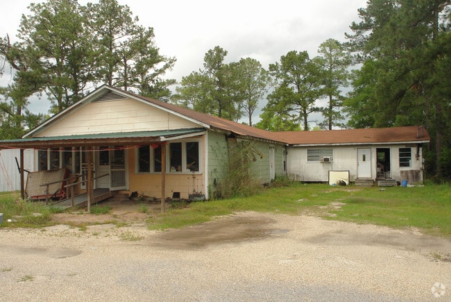
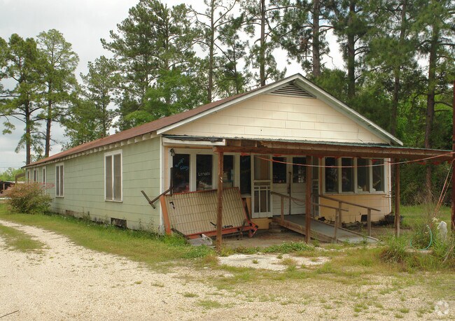
Property Record
2417 E Canal St, Picayune, MS 39466

Save to a Folder
{{folder.Name}}
{{folder.ListingIds.length}} Properties
{{folder.ListingIds.length}} Property
Create a New Folder
Property Detail
2417 E Canal St
6-16-4-18-000-000-3200
1 AC IN SW1/4 SW1/4
Warehouse
PEARL RIVER
AE The base floodplain where base flood elevations are provided. AE Zones are now used on new format FIRMs instead of A1-A30 Zones.
Mississippi
2025
1 AC
2025
Other Market Areas
950504
Picayune, MS
3,200 SF
NEARBY LISTINGS FOR SALE OR LEASE
DEMOGRAPHICS near 2417 E Canal St
1 mile
3 mile
5 mile
2025 Total Population
766
11,980
25,227
2030 Population
811
12,518
26,260
Pop Growth 2025-2030
+ 5.87%
+ 4.49%
+ 4.09%
Average Age
46
42
42
2025 Total Households
302
4,847
10,085
HH Growth 2025-2030
+ 5.96%
+ 4.52%
+ 4.12%
Median Household Inc
$33,571
$45,857
$51,095
Avg Household Size
2.50
2.40
2.40
2025 Avg HH Vehicles
2.00
2.00
2.00
Median Home Value
$124,324
$160,196
$173,223
Median Year Built
1989
1980
1987
Nearby Places
Map Layers
Map Styles
 Street
 Aerial
Layers
 Traffic
 Biking
Places
Listings with unknown addresses are not visible on the map
- Restaurants
- Banks
- Shops
- Fitness
- Groceries
PUBLIC TRANSPORTATION
COMMUTER RAIL
Picayune Amtrak Station (Crescent - Amtrak)
Drive
Walk
Distance
Picayune Amtrak Station (Crescent - Amtrak)
4 min
2.7 mi
Freight Ports
Port of Gulf Port
Drive
Walk
Distance
Port of Gulf Port
64 min
47.7 mi
Nearby Properties
Address
Land Use
TOTAL SIZE
Lot Size
Zoning
Address
Land Use
TOTAL SIZE
Lot Size
Zoning
112,716 SF
28.68 AC
Address
Land Use
TOTAL SIZE
Lot Size
Zoning
36,353 SF
0.51 AC
Address
Land Use
TOTAL SIZE
Lot Size
Zoning
17,787 SF
4.61 AC
Address
Land Use
TOTAL SIZE
Lot Size
Zoning
33,696 SF
9.12 AC
Address
Land Use
TOTAL SIZE
Lot Size
Zoning
15,092 SF
3.14 AC
Address
Land Use
TOTAL SIZE
Lot Size
Zoning
45,886 SF
2.12 AC
Address
Land Use
TOTAL SIZE
Lot Size
Zoning
16,704 SF
0.24 AC
Address
Land Use
TOTAL SIZE
Lot Size
Zoning
48,002 SF
2.57 AC
Address
Land Use
TOTAL SIZE
Lot Size
Zoning
55,428 SF
5.50 AC
Address
Land Use
TOTAL SIZE
Lot Size
Zoning
24,000 SF
22.18 AC
Address
Land Use
TOTAL SIZE
Lot Size
Zoning
181,777 SF
24.60 AC
Address
Land Use
TOTAL SIZE
Lot Size
Zoning
40,140 SF
0.49 AC
Address
Land Use
TOTAL SIZE
Lot Size
Zoning
2,441 SF
125.10 AC
Address
Land Use
TOTAL SIZE
Lot Size
Zoning
15,110 SF
2.62 AC
Address
Land Use
TOTAL SIZE
Lot Size
Zoning
17,724 SF
7.23 AC
Address
Land Use
TOTAL SIZE
Lot Size
Zoning
15,180 SF
10.16 AC
Address
Land Use
TOTAL SIZE
Lot Size
Zoning
12,300 SF
1.85 AC
Address
Land Use
TOTAL SIZE
Lot Size
Zoning
31,150 SF
7.82 AC
Address
Land Use
TOTAL SIZE
Lot Size
Zoning
106,981 SF
21.70 AC
Address
Land Use
TOTAL SIZE
Lot Size
Zoning
62,918 SF
8.77 AC
Address
Land Use
TOTAL SIZE
Lot Size
Zoning
6,329 SF
0.67 AC
Address
Land Use
TOTAL SIZE
Lot Size
Zoning
2,241 SF
13.63 AC
Address
Land Use
TOTAL SIZE
Lot Size
Zoning
26,206 SF
3.29 AC
Address
Land Use
TOTAL SIZE
Lot Size
Zoning
7,589 SF
2.65 AC
Address
Land Use
TOTAL SIZE
Lot Size
Zoning
10,983 SF
2 AC
Address
Land Use
TOTAL SIZE
Lot Size
Zoning
11,898 SF
7 AC
Address
Land Use
TOTAL SIZE
Lot Size
Zoning
8,880 SF
2.53 AC
Address
Land Use
TOTAL SIZE
Lot Size
Zoning
21,864 SF
1 AC
Address
Land Use
TOTAL SIZE
Lot Size
Zoning
5,987 SF
9 AC
Address
Land Use
TOTAL SIZE
Lot Size
Zoning
3,900 SF
2.87 AC
The World's #1 Commercial Real Estate Marketplace
Connect with us
© 2026 CoStar Group
The information above has been obtained from sources believed reliable. While we do not doubt its accuracy we have not verified it and make no guarantee, warranty or representation about it. It is your responsibility to independently confirm its accuracy and completeness. Any projections, opinions, assumptions, or estimates used are for example only and do not represent the current or future performance of the property. The value of this transaction to you depends on tax and other factors which should be evaluated by your tax, financial, and legal advisors. You and your advisors should conduct a careful, independent investigation of the property to determine to your satisfaction the suitability of the property for your needs.