Property Record
2417 E Murphy Woods Rd, Beloit, WI 53511

Save to a Folder
{{folder.Name}}
{{folder.ListingIds.length}} Properties
{{folder.ListingIds.length}} Property
Create a New Folder
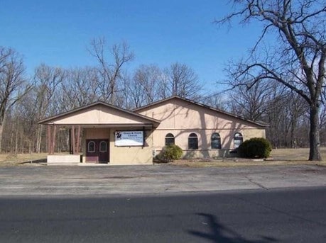
Property Detail
2417 E Murphy Woods Rd
Janesville-Beloit, WI
PT L18 SCHUSTERS WHITE OAK CERTIFIED SURVEY MAP #828769 VOL 4 PG 327-328 LOT 2
619-2042
ROCK
Commercialnec
Wisconsin
A1
2
B and X Area of moderate flood hazard, usually the area between the limits of the 100-year and 500-year floods.
0.92 AC
2025
Rock County
2025
Milwaukee/Madison
002601
NEARBY LISTINGS FOR SALE OR LEASE
DEMOGRAPHICS near 2417 E Murphy Woods Rd
1 mile
3 mile
5 mile
2025 Total Population
5,691
28,381
57,480
2030 Population
5,693
28,646
58,111
Pop Growth 2025-2030
+ 0.04%
+ 0.93%
+ 1.10%
Average Age
43
41
40
2025 Total Households
2,401
11,324
22,497
HH Growth 2025-2030
+ 0.04%
+ 0.97%
+ 1.11%
Median Household Inc
$79,421
$67,450
$65,922
Avg Household Size
2.30
2.40
2.40
2025 Avg HH Vehicles
2.00
2.00
2.00
Median Home Value
$223,437
$214,899
$184,650
Median Year Built
1974
1965
1964
Nearby Places
Map Layers
Map Styles
 Street
 Aerial
Layers
 Traffic
 Biking
Places
Listings with unknown addresses are not visible on the map
- Restaurants
- Banks
- Shops
- Fitness
- Groceries
PUBLIC TRANSPORTATION
AIRPORT
Chicago/Rockford International
Drive
Walk
Distance
Chicago/Rockford International
48 min
34.2 mi
SALE & LEASE HISTORY
LISTING DATE
SALE/LEASE

Sep 23, 2016
For Sale
May 02, 2017
For Sale
Nearby Properties
Address
Land Use
TOTAL SIZE
Lot Size
Zoning
Address
Land Use
TOTAL SIZE
Lot Size
Zoning
700,000 SF
80.08 AC
Address
Land Use
TOTAL SIZE
Lot Size
Zoning
264,000 SF
34 AC
Address
Land Use
TOTAL SIZE
Lot Size
Zoning
37.49 AC
CHI
Address
Land Use
TOTAL SIZE
Lot Size
Zoning
8.01 AC
Address
Land Use
TOTAL SIZE
Lot Size
Zoning
39.83 AC
Address
Land Use
TOTAL SIZE
Lot Size
Zoning
24.76 AC
Address
Land Use
TOTAL SIZE
Lot Size
Zoning
36,860 SF
11.26 AC
Address
Land Use
TOTAL SIZE
Lot Size
Zoning
61,820 SF
5.63 AC
Address
Land Use
TOTAL SIZE
Lot Size
Zoning
103,761 SF
21.59 AC
Address
Land Use
TOTAL SIZE
Lot Size
Zoning
55.03 AC
Address
Land Use
TOTAL SIZE
Lot Size
Zoning
7.71 AC
Address
Land Use
TOTAL SIZE
Lot Size
Zoning
400,014 SF
43.71 AC
Address
Land Use
TOTAL SIZE
Lot Size
Zoning
32.08 AC
Address
Land Use
TOTAL SIZE
Lot Size
Zoning
3.47 AC
Address
Land Use
TOTAL SIZE
Lot Size
Zoning
141,745 SF
12.20 AC
Address
Land Use
TOTAL SIZE
Lot Size
Zoning
100,000 SF
14.54 AC
Address
Land Use
TOTAL SIZE
Lot Size
Zoning
233,850 SF
30.40 AC
Address
Land Use
TOTAL SIZE
Lot Size
Zoning
3.65 AC
Address
Land Use
TOTAL SIZE
Lot Size
Zoning
20.83 AC
Address
Land Use
TOTAL SIZE
Lot Size
Zoning
13.21 AC
Address
Land Use
TOTAL SIZE
Lot Size
Zoning
2,728 SF
10 AC
Address
Land Use
TOTAL SIZE
Lot Size
Zoning
231,166 SF
19.25 AC
Address
Land Use
TOTAL SIZE
Lot Size
Zoning
361,947 SF
23.26 AC
Address
Land Use
TOTAL SIZE
Lot Size
Zoning
24.15 AC
Address
Land Use
TOTAL SIZE
Lot Size
Zoning
193,013 SF
22.93 AC
Address
Land Use
TOTAL SIZE
Lot Size
Zoning
38,012 SF
2.74 AC
Address
Land Use
TOTAL SIZE
Lot Size
Zoning
40,800 SF
81.29 AC
Address
Land Use
TOTAL SIZE
Lot Size
Zoning
22.90 AC
Address
Land Use
TOTAL SIZE
Lot Size
Zoning
100,000 SF
14.78 AC
Address
Land Use
TOTAL SIZE
Lot Size
Zoning
27.69 AC
The World's #1 Commercial Real Estate Marketplace
Connect with us
© 2026 CoStar Group
The information above has been obtained from sources believed reliable. While we do not doubt its accuracy we have not verified it and make no guarantee, warranty or representation about it. It is your responsibility to independently confirm its accuracy and completeness. Any projections, opinions, assumptions, or estimates used are for example only and do not represent the current or future performance of the property. The value of this transaction to you depends on tax and other factors which should be evaluated by your tax, financial, and legal advisors. You and your advisors should conduct a careful, independent investigation of the property to determine to your satisfaction the suitability of the property for your needs.