Property Record
24175 Point Lookout Rd, Leonardtown, MD 20650

NEARBY LISTINGS FOR SALE OR LEASE
-
-
View all Leonardtown listings for sale on LoopNet.com
Property Detail
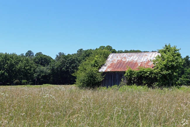
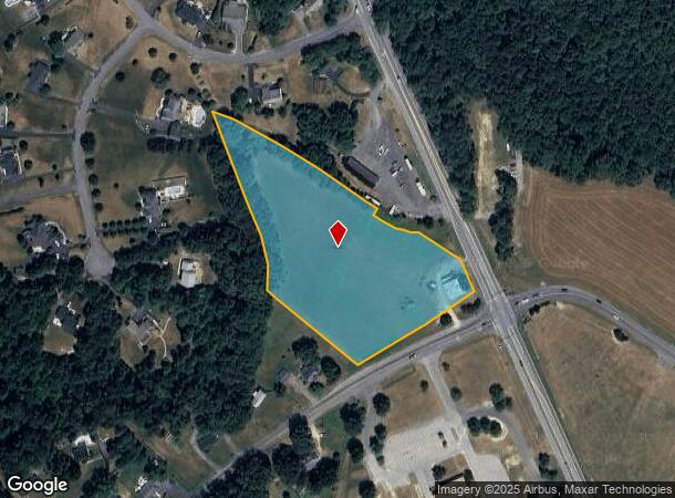
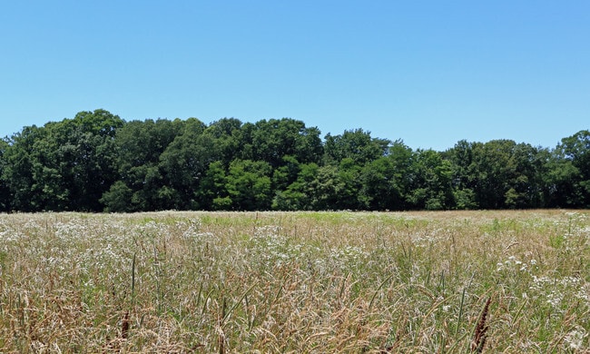
24175 Point Lookout Rd
03-009343
5.4 ACRES CORNER RT 5 & RT 244 LEONARDTOWN
Multifamilydwelling
St Marys
X
Maryland
24037C0188G
5.40 AC
2025
St Mary's County
2025
Washington, DC
875400
California-Lexington Park, MD
4,248 SF
DEMOGRAPHICS near 24175 Point Lookout Rd
1 Mile
3 Mile
5 Mile
2024 Total Population
430
8,631
25,713
2029 Population
448
8,893
26,506
Pop Growth 2024-2029
+ 4.19%
+ 3.04%
+ 3.08%
Average Age
41
39
39
2024 Total Households
163
3,078
9,248
HH Growth 2024-2029
+ 4.29%
+ 2.89%
+ 3.02%
Median Household Inc
$158,036
$136,237
$130,330
Avg Household Size
2.60
2.70
2.70
2024 Avg HH Vehicles
3.00
2.00
2.00
Median Home Value
$423,585
$429,767
$401,165
Median Year Built
1994
1998
1999
Nearby Places
Map Layers
Map Styles
 Street
 Aerial
- Restaurants
- Banks
- Shops
- Fitness
- Groceries
SALE & LEASE HISTORY
LISTING DATE
SALE/LEASE

Jan 04, 2023
For Sale
Nearby Properties
Address
Land Use
TOTAL SIZE
Lot Size
Zoning
Address
Land Use
TOTAL SIZE
Lot Size
Zoning
3,675 SF
32.13 AC
I-O
Address
Land Use
TOTAL SIZE
Lot Size
Zoning
225,767 SF
121.08 AC
RPD
Address
Land Use
TOTAL SIZE
Lot Size
Zoning
61,684 SF
85.36 AC
PUD 5
Address
Land Use
TOTAL SIZE
Lot Size
Zoning
156,000 SF
12.07 AC
PUD-5
Address
Land Use
TOTAL SIZE
Lot Size
Zoning
2,920 SF
37.49 AC
R-SF
Address
Land Use
TOTAL SIZE
Lot Size
Zoning
27,931 SF
105.33 AC
RL
Address
Land Use
TOTAL SIZE
Lot Size
Zoning
75,772 SF
16.22 AC
RL
Address
Land Use
TOTAL SIZE
Lot Size
Zoning
24,414 SF
4.71 AC
R-MF
Address
Land Use
TOTAL SIZE
Lot Size
Zoning
15,715 SF
142.61 AC
RL
Address
Land Use
TOTAL SIZE
Lot Size
Zoning
59,600 SF
5.58 AC
PUD-M
Address
Land Use
TOTAL SIZE
Lot Size
Zoning
72,810 SF
0.25 AC
C-G
Address
Land Use
TOTAL SIZE
Lot Size
Zoning
71,646 SF
17.83 AC
I-O
Address
Land Use
TOTAL SIZE
Lot Size
Zoning
83,860 SF
2.49 AC
RMF
Address
Land Use
TOTAL SIZE
Lot Size
Zoning
77,920 SF
5.47 AC
PUD 5
Address
Land Use
TOTAL SIZE
Lot Size
Zoning
23,536 SF
47.36 AC
RPD
Address
Land Use
TOTAL SIZE
Lot Size
Zoning
716.60 AC
RPD
Address
Land Use
TOTAL SIZE
Lot Size
Zoning
14,550 SF
51.26 AC
R-SF
Address
Land Use
TOTAL SIZE
Lot Size
Zoning
39,531 SF
1.13 AC
RMF
Address
Land Use
TOTAL SIZE
Lot Size
Zoning
15,000 SF
3.91 AC
C-G
Address
Land Use
TOTAL SIZE
Lot Size
Zoning
187.31 AC
PUD5
Address
Land Use
TOTAL SIZE
Lot Size
Zoning
7,804 SF
14.93 AC
RL
Address
Land Use
TOTAL SIZE
Lot Size
Zoning
9,300 SF
4.50 AC
RMX
Address
Land Use
TOTAL SIZE
Lot Size
Zoning
960 SF
1.70 AC
PUD-5
Address
Land Use
TOTAL SIZE
Lot Size
Zoning
15,582 SF
1.20 AC
C-O
Address
Land Use
TOTAL SIZE
Lot Size
Zoning
6,274 SF
0.83 AC
C-G
Address
Land Use
TOTAL SIZE
Lot Size
Zoning
3,128 SF
197.40 AC
RNC
Address
Land Use
TOTAL SIZE
Lot Size
Zoning
1,859 SF
2.36 AC
R-MF
Address
Land Use
TOTAL SIZE
Lot Size
Zoning
28,760 SF
3.05 AC
I-O
Address
Land Use
TOTAL SIZE
Lot Size
Zoning
26,760 SF
1 AC
RMF
Address
Land Use
TOTAL SIZE
Lot Size
Zoning
3,162 SF
10.03 AC
RPD
The World's #1 Commercial Real Estate Marketplace
Connect with us
© 2025 CoStar Group
The information above has been obtained from sources believed reliable. While we do not doubt its accuracy we have not verified it and make no guarantee, warranty or representation about it. It is your responsibility to independently confirm its accuracy and completeness. Any projections, opinions, assumptions, or estimates used are for example only and do not represent the current or future performance of the property. The value of this transaction to you depends on tax and other factors which should be evaluated by your tax, financial, and legal advisors. You and your advisors should conduct a careful, independent investigation of the property to determine to your satisfaction the suitability of the property for your needs.