Property Record
2418 Mill Rd, Powhatan, VA 23139


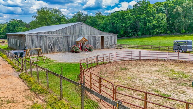
Property Detail
2418 Mill Rd
Richmond, VA
ROUTE 614 PARCEL A
029-10B
Powhatan
Miscresidentialimprovement
Virginia
A-10
10b
B and X Area of moderate flood hazard, usually the area between the limits of the 100-year and 500-year floods.
13.82 AC
2026
Powhatan
2026
Richmond VA
500101
NEARBY LISTINGS FOR SALE OR LEASE
-
-
No Photo
-
View all Powhatan listings for sale on LoopNet.com
DEMOGRAPHICS near 2418 Mill Rd
1 mile
3 mile
5 mile
2025 Total Population
701
6,812
14,924
2030 Population
726
7,064
15,496
Pop Growth 2025-2030
+ 3.57%
+ 3.70%
+ 3.83%
Average Age
44
44
44
2025 Total Households
276
2,600
5,351
HH Growth 2025-2030
+ 3.62%
+ 3.77%
+ 4.00%
Median Household Inc
$88,911
$104,111
$110,943
Avg Household Size
2.40
2.60
2.60
2025 Avg HH Vehicles
2.00
3.00
3.00
Median Home Value
$357,746
$377,061
$413,306
Median Year Built
1983
1987
1990
Nearby Places
Map Layers
Map Styles
 Street
 Aerial
Layers
 Traffic
 Biking
Places
Listings with unknown addresses are not visible on the map
- Restaurants
- Banks
- Shops
- Fitness
- Groceries
PUBLIC TRANSPORTATION
AIRPORT
Richmond International
Drive
Walk
Distance
Richmond International
62 min
39.2 mi
Freight Ports
Virginia Port Authority - Richmond
Drive
Walk
Distance
Virginia Port Authority - Richmond
52 min
29.3 mi
SALE & LEASE HISTORY
LISTING DATE
SALE/LEASE

May 21, 2025
For Sale
Nearby Properties
Address
Land Use
TOTAL SIZE
Lot Size
Zoning
Address
Land Use
TOTAL SIZE
Lot Size
Zoning
291,788 SF
61.70 AC
A-10
Address
Land Use
TOTAL SIZE
Lot Size
Zoning
96,428 SF
20.87 AC
A-10
Address
Land Use
TOTAL SIZE
Lot Size
Zoning
15,322 SF
37.84 AC
I-2
Address
Land Use
TOTAL SIZE
Lot Size
Zoning
49,360 SF
17 AC
I-2
Address
Land Use
TOTAL SIZE
Lot Size
Zoning
2,747 SF
232.38 AC
A-10
Address
Land Use
TOTAL SIZE
Lot Size
Zoning
2,309 SF
10.79 AC
A-10
Address
Land Use
TOTAL SIZE
Lot Size
Zoning
21,914 SF
6.95 AC
CC
Address
Land Use
TOTAL SIZE
Lot Size
Zoning
55,489 SF
10.09 AC
CC
Address
Land Use
TOTAL SIZE
Lot Size
Zoning
12,817 SF
4 AC
A-10
Address
Land Use
TOTAL SIZE
Lot Size
Zoning
10,890 SF
14.22 AC
A-10
Address
Land Use
TOTAL SIZE
Lot Size
Zoning
5,331 SF
2 AC
CC
Address
Land Use
TOTAL SIZE
Lot Size
Zoning
11,568 SF
14.22 AC
A-10
Address
Land Use
TOTAL SIZE
Lot Size
Zoning
6,624 SF
4.51 AC
I-2
Address
Land Use
TOTAL SIZE
Lot Size
Zoning
9,710 SF
1.68 AC
CC
Address
Land Use
TOTAL SIZE
Lot Size
Zoning
11,121 SF
6.22 AC
CC
Address
Land Use
TOTAL SIZE
Lot Size
Zoning
3,989 SF
2.16 AC
CC
Address
Land Use
TOTAL SIZE
Lot Size
Zoning
7,295 SF
1.24 AC
CC
Address
Land Use
TOTAL SIZE
Lot Size
Zoning
1,680 SF
6.48 AC
CC
Address
Land Use
TOTAL SIZE
Lot Size
Zoning
3,047 SF
16.51 AC
CC
Address
Land Use
TOTAL SIZE
Lot Size
Zoning
11,520 SF
1.87 AC
CC
Address
Land Use
TOTAL SIZE
Lot Size
Zoning
315.84 AC
A-10
Address
Land Use
TOTAL SIZE
Lot Size
Zoning
11,200 SF
2.28 AC
CC
Address
Land Use
TOTAL SIZE
Lot Size
Zoning
12,552 SF
3 AC
CC
Address
Land Use
TOTAL SIZE
Lot Size
Zoning
9,514 SF
1.63 AC
CC
Address
Land Use
TOTAL SIZE
Lot Size
Zoning
6,056 SF
1.19 AC
CC
Address
Land Use
TOTAL SIZE
Lot Size
Zoning
13,896 SF
2.59 AC
I-2
Address
Land Use
TOTAL SIZE
Lot Size
Zoning
1,084 SF
3.50 AC
CC
Address
Land Use
TOTAL SIZE
Lot Size
Zoning
7,905 SF
5.92 AC
CC
Address
Land Use
TOTAL SIZE
Lot Size
Zoning
14,140 SF
2.01 AC
I-2
Address
Land Use
TOTAL SIZE
Lot Size
Zoning
19,150 SF
1.91 AC
CC
The World's #1 Commercial Real Estate Marketplace
Connect with us
© 2026 CoStar Group
The information above has been obtained from sources believed reliable. While we do not doubt its accuracy we have not verified it and make no guarantee, warranty or representation about it. It is your responsibility to independently confirm its accuracy and completeness. Any projections, opinions, assumptions, or estimates used are for example only and do not represent the current or future performance of the property. The value of this transaction to you depends on tax and other factors which should be evaluated by your tax, financial, and legal advisors. You and your advisors should conduct a careful, independent investigation of the property to determine to your satisfaction the suitability of the property for your needs.