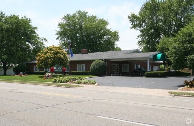
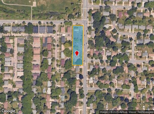
Property Record
2418 N Sherman Ave, Madison, WI 53704
NEARBY LISTINGS FOR SALE OR LEASE
Property Detail
2418 N Sherman Ave
0809-364-0101-9
T8n R9e, Sec 36, Part Ne 1/4 Se 1/4
Commercialnec
T8N R9E, SEC 36, PART NE 1/4 SE 1/4, DESC AS FOL, BEG AT THE INTERS S LN TRAILSW AY AND THE W LN N SHERMAN AVE, TH WLY ALG SD S LN 120 FT, TH S PARA TO W LN N SH ERMAN AVE 446 FT, TH ELY 120 FT TO SD W LN, TH N 446 FT TO POB
X
Dane
55025C0263H
Wisconsin
2024
1.23 AC
2024
Northeast Madison
002200
Milwaukee/Madison
5,000 SF
Madison, WI
DEMOGRAPHICS near 2418 N Sherman Ave
1 Mile
3 Mile
5 Mile
2024 Total Population
10,314
52,743
157,882
2029 Population
10,764
54,691
162,793
Pop Growth 2024-2029
+ 4.36%
+ 3.69%
+ 3.11%
Average Age
40
40
36
2024 Total Households
4,708
25,285
70,155
HH Growth 2024-2029
+ 4.44%
+ 3.80%
+ 3.37%
Median Household Inc
$56,614
$65,319
$59,944
Avg Household Size
2.10
2.00
2.00
2024 Avg HH Vehicles
2.00
2.00
1.00
Median Home Value
$227,850
$263,699
$290,205
Median Year Built
1967
1962
1973
Nearby Places
Map Layers
Map Styles
 Street
 Aerial
- Restaurants
- Banks
- Shops
- Fitness
- Groceries
PUBLIC TRANSPORTATION
AIRPORT
Dane County Regional/Truax Field
DRIVE
WALK
Distance
Dane County Regional/Truax Field
5 min
1.9 mi
Nearby Properties
Address
Land Use
TOTAL SIZE
Lot Size
Zoning
Address
Land Use
TOTAL SIZE
Lot Size
Zoning
509,946 SF
40.17 AC
IL
Address
Land Use
TOTAL SIZE
Lot Size
Zoning
461,454 SF
3.37 AC
CC-T
Address
Land Use
TOTAL SIZE
Lot Size
Zoning
251,632 SF
3.88 AC
TE
Address
Land Use
TOTAL SIZE
Lot Size
Zoning
216,017 SF
3.35 AC
TE
Address
Land Use
TOTAL SIZE
Lot Size
Zoning
197,046 SF
TE
Address
Land Use
TOTAL SIZE
Lot Size
Zoning
115,920 SF
2.38 AC
TE
Address
Land Use
TOTAL SIZE
Lot Size
Zoning
294,106 SF
29.06 AC
CC
Address
Land Use
TOTAL SIZE
Lot Size
Zoning
104,000 SF
11.21 AC
CC-T
Address
Land Use
TOTAL SIZE
Lot Size
Zoning
58,680 SF
6.29 AC
PD
Address
Land Use
TOTAL SIZE
Lot Size
Zoning
Address
Land Use
TOTAL SIZE
Lot Size
Zoning
92,130 SF
3.36 AC
PD
Address
Land Use
TOTAL SIZE
Lot Size
Zoning
105,743 SF
9.50 AC
IG
Address
Land Use
TOTAL SIZE
Lot Size
Zoning
37,133 SF
4.71 AC
CC-T
Address
Land Use
TOTAL SIZE
Lot Size
Zoning
101,080 SF
1.02 AC
CC-T
Address
Land Use
TOTAL SIZE
Lot Size
Zoning
68,016 SF
6.45 AC
PD
Address
Land Use
TOTAL SIZE
Lot Size
Zoning
121,013 SF
0.98 AC
TSS
Address
Land Use
TOTAL SIZE
Lot Size
Zoning
1.64 AC
CC-T
Address
Land Use
TOTAL SIZE
Lot Size
Zoning
55,295 SF
0.01 AC
TE
Address
Land Use
TOTAL SIZE
Lot Size
Zoning
58,817 SF
13.79 AC
SE
Address
Land Use
TOTAL SIZE
Lot Size
Zoning
86,935 SF
41.37 AC
PD
Address
Land Use
TOTAL SIZE
Lot Size
Zoning
68,064 SF
26.16 AC
TE
Address
Land Use
TOTAL SIZE
Lot Size
Zoning
78,300 SF
14.35 AC
CC
Address
Land Use
TOTAL SIZE
Lot Size
Zoning
48,970 SF
3.80 AC
PD
Address
Land Use
TOTAL SIZE
Lot Size
Zoning
83,769 SF
1.10 AC
NMX
Address
Land Use
TOTAL SIZE
Lot Size
Zoning
15,886 SF
1.99 AC
PD
Address
Land Use
TOTAL SIZE
Lot Size
Zoning
129,332 SF
22.78 AC
CC
Address
Land Use
TOTAL SIZE
Lot Size
Zoning
52.10 AC
PMHP
Address
Land Use
TOTAL SIZE
Lot Size
Zoning
104,460 SF
16.33 AC
CC-T
Address
Land Use
TOTAL SIZE
Lot Size
Zoning
72,945 SF
8.06 AC
CC
Address
Land Use
TOTAL SIZE
Lot Size
Zoning
51,013 SF
79.90 AC
PD
The World's #1 Commercial Real Estate Marketplace
Connect with us
© 2025 CoStar Group
The information above has been obtained from sources believed reliable. While we do not doubt its accuracy we have not verified it and make no guarantee, warranty or representation about it. It is your responsibility to independently confirm its accuracy and completeness. Any projections, opinions, assumptions, or estimates used are for example only and do not represent the current or future performance of the property. The value of this transaction to you depends on tax and other factors which should be evaluated by your tax, financial, and legal advisors. You and your advisors should conduct a careful, independent investigation of the property to determine to your satisfaction the suitability of the property for your needs.