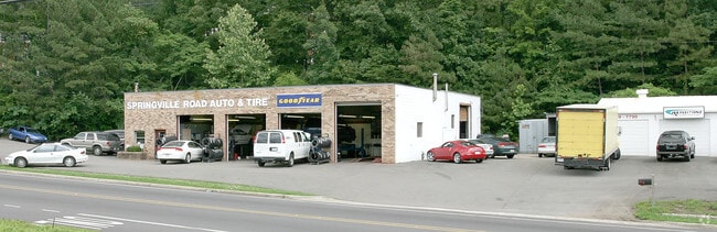
Property Record
2419 Old Springville Rd, Birmingham, AL 35215

NEARBY LISTINGS FOR SALE OR LEASE
Property Detail
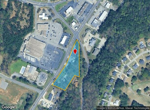
2419 Old Springville Rd
12-00-09-3-000-039.001
COM SE COR OF SE 1/4 OF SW 1/4 SEC 9 TP 16 R 1W TH N 531.7 FT TH NW 200.5 FT TO POB TH CONT NW 185 FT TH NELY ALG OLD SPRINGVILLE RD 692.4 FT TH SE 42 FT TH S 440 FT TH NW 70 FT TH SWLY 246.5 FT TO POB
Autorepair
Jefferson
X
Alabama
01073C0244J
2.24 AC
2023
Center Point
2024
Birmingham
011112
Birmingham-Hoover, AL
6,609 SF
DEMOGRAPHICS near 2419 Old Springville Rd
1 Mile
3 Mile
5 Mile
2024 Total Population
7,587
45,840
88,241
2029 Population
7,370
44,752
86,137
Pop Growth 2024-2029
(2.86%)
(2.37%)
(2.38%)
Average Age
37
37
38
2024 Total Households
2,891
17,209
33,048
HH Growth 2024-2029
(2.94%)
(2.41%)
(2.45%)
Median Household Inc
$53,554
$53,640
$57,251
Avg Household Size
2.50
2.60
2.60
2024 Avg HH Vehicles
2.00
2.00
2.00
Median Home Value
$146,306
$160,689
$168,113
Median Year Built
1987
1980
1979
Nearby Places
Map Layers
Map Styles
 Street
 Aerial
- Restaurants
- Banks
- Shops
- Fitness
- Groceries
PUBLIC TRANSPORTATION
AIRPORT
Birmingham-Shuttlesworth International
DRIVE
WALK
Distance
Birmingham-Shuttlesworth International
18 min
11.0 mi
Freight Ports
Port of Mobile
DRIVE
WALK
Distance
Port of Mobile
295 min
269.3 mi
Nearby Properties
Address
Land Use
TOTAL SIZE
Lot Size
Zoning
Address
Land Use
TOTAL SIZE
Lot Size
Zoning
204,463 SF
32.90 AC
PUD
Address
Land Use
TOTAL SIZE
Lot Size
Zoning
150,160 SF
12 AC
INST
Address
Land Use
TOTAL SIZE
Lot Size
Zoning
144,921 SF
9 AC
R4
Address
Land Use
TOTAL SIZE
Lot Size
Zoning
204,269 SF
17.94 AC
PUD
Address
Land Use
TOTAL SIZE
Lot Size
Zoning
207,383 SF
17 AC
CR5
Address
Land Use
TOTAL SIZE
Lot Size
Zoning
134,442 SF
26 AC
PUD
Address
Land Use
TOTAL SIZE
Lot Size
Zoning
192,596 SF
13.79 AC
CR5
Address
Land Use
TOTAL SIZE
Lot Size
Zoning
125,252 SF
8.07 AC
R4
Address
Land Use
TOTAL SIZE
Lot Size
Zoning
74,218 SF
4.50 AC
C2
Address
Land Use
TOTAL SIZE
Lot Size
Zoning
89,761 SF
11 AC
PUD
Address
Land Use
TOTAL SIZE
Lot Size
Zoning
116,732 SF
4.06 AC
R-4
Address
Land Use
TOTAL SIZE
Lot Size
Zoning
87,142 SF
10.80 AC
C-2
Address
Land Use
TOTAL SIZE
Lot Size
Zoning
43,451 SF
5.22 AC
INST
Address
Land Use
TOTAL SIZE
Lot Size
Zoning
109,878 SF
10 AC
C1
Address
Land Use
TOTAL SIZE
Lot Size
Zoning
11,872 SF
3.38 AC
QC2
Address
Land Use
TOTAL SIZE
Lot Size
Zoning
74,159 SF
2.50 AC
INST
Address
Land Use
TOTAL SIZE
Lot Size
Zoning
43,298 SF
5.59 AC
INST
Address
Land Use
TOTAL SIZE
Lot Size
Zoning
4.21 AC
C2
Address
Land Use
TOTAL SIZE
Lot Size
Zoning
19,632 SF
1.79 AC
QC2
Address
Land Use
TOTAL SIZE
Lot Size
Zoning
58,296 SF
6.25 AC
PUD
Address
Land Use
TOTAL SIZE
Lot Size
Zoning
56,360 SF
2.80 AC
INST
Address
Land Use
TOTAL SIZE
Lot Size
Zoning
39,251 SF
5.20 AC
C1
Address
Land Use
TOTAL SIZE
Lot Size
Zoning
35,445 SF
5.30 AC
C2
Address
Land Use
TOTAL SIZE
Lot Size
Zoning
69,066 SF
7.30 AC
C1
Address
Land Use
TOTAL SIZE
Lot Size
Zoning
25,408 SF
3.30 AC
C2
Address
Land Use
TOTAL SIZE
Lot Size
Zoning
20,036 SF
1.25 AC
PUD
Address
Land Use
TOTAL SIZE
Lot Size
Zoning
118,041 SF
5.10 AC
C1
Address
Land Use
TOTAL SIZE
Lot Size
Zoning
74,190 SF
8.80 AC
C2
Address
Land Use
TOTAL SIZE
Lot Size
Zoning
24,461 SF
1.35 AC
C1&C
Address
Land Use
TOTAL SIZE
Lot Size
Zoning
26,773 SF
22 AC
U1
The World's #1 Commercial Real Estate Marketplace
Connect with us
© 2025 CoStar Group
The information above has been obtained from sources believed reliable. While we do not doubt its accuracy we have not verified it and make no guarantee, warranty or representation about it. It is your responsibility to independently confirm its accuracy and completeness. Any projections, opinions, assumptions, or estimates used are for example only and do not represent the current or future performance of the property. The value of this transaction to you depends on tax and other factors which should be evaluated by your tax, financial, and legal advisors. You and your advisors should conduct a careful, independent investigation of the property to determine to your satisfaction the suitability of the property for your needs.