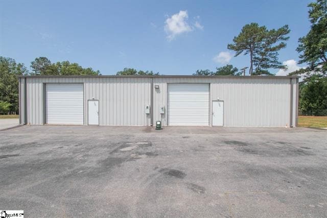
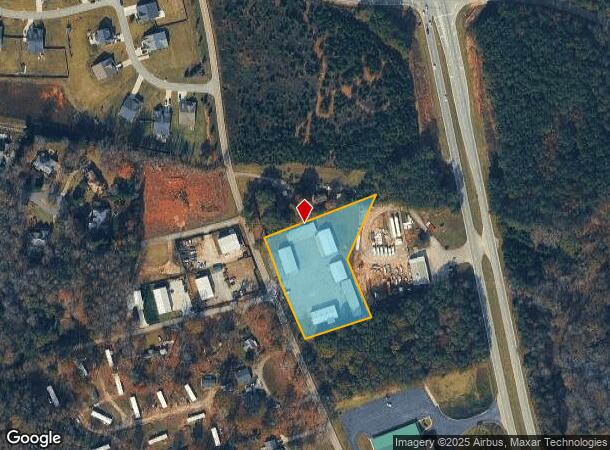
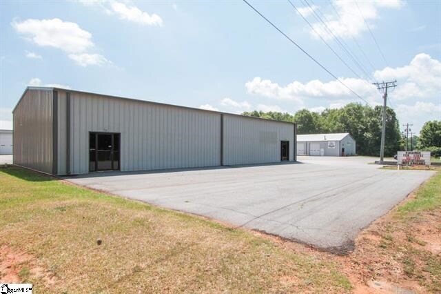
Property Record
2419 Powdersville Rd, Easley, SC 29642
NEARBY LISTINGS FOR SALE OR LEASE
Property Detail
2419 Powdersville Rd
212-08-03-004
CP 118/479 PP S 780/6A F000 D000 PP 097/726 TR B POWDERSVILLE RD 2.39 AC
Commercialnec
Anderson
X
South Carolina
45007C0042E
2.39 AC
2025
Rt 153/Rt 123 Corr
2024
Greenville/Spartanburg
010103
Greenville-Anderson-Mauldin, SC
3,200 SF
DEMOGRAPHICS near 2419 Powdersville Rd
1 Mile
3 Mile
5 Mile
2024 Total Population
2,147
25,821
63,871
2029 Population
2,242
27,188
68,066
Pop Growth 2024-2029
+ 4.42%
+ 5.29%
+ 6.57%
Average Age
39
40
40
2024 Total Households
810
9,896
24,715
HH Growth 2024-2029
+ 4.32%
+ 5.25%
+ 6.55%
Median Household Inc
$64,821
$66,113
$59,958
Avg Household Size
2.60
2.60
2.50
2024 Avg HH Vehicles
2.00
2.00
2.00
Median Home Value
$199,523
$230,253
$208,307
Median Year Built
1992
1993
1989
Nearby Places
Map Layers
Map Styles
 Street
 Aerial
- Restaurants
- Banks
- Shops
- Fitness
- Groceries
PUBLIC TRANSPORTATION
COMMUTER RAIL
Greenville Amtrak Station (Crescent - Amtrak)
DRIVE
WALK
Distance
Greenville Amtrak Station (Crescent - Amtrak)
19 min
9.9 mi
AIRPORT
Greenville Spartanburg International
DRIVE
WALK
Distance
Greenville Spartanburg International
33 min
22.1 mi
Freight Ports
North Charleston Terminal
DRIVE
WALK
Distance
North Charleston Terminal
236 min
208.5 mi
SALE & LEASE HISTORY
LISTING DATE
SALE/LEASE

Sep 25, 2016
For Lease
Nearby Properties
Address
Land Use
TOTAL SIZE
Lot Size
Zoning
Address
Land Use
TOTAL SIZE
Lot Size
Zoning
16.29 AC
GENERAL CO
Address
Land Use
TOTAL SIZE
Lot Size
Zoning
19,164 SF
3.22 AC
GC
Address
Land Use
TOTAL SIZE
Lot Size
Zoning
14,544 SF
22.61 AC
Address
Land Use
TOTAL SIZE
Lot Size
Zoning
13.75 AC
GC
Address
Land Use
TOTAL SIZE
Lot Size
Zoning
49,803 SF
18.36 AC
GC
Address
Land Use
TOTAL SIZE
Lot Size
Zoning
4,200 SF
0.98 AC
GC
Address
Land Use
TOTAL SIZE
Lot Size
Zoning
683 SF
16.53 AC
Address
Land Use
TOTAL SIZE
Lot Size
Zoning
36.37 AC
Address
Land Use
TOTAL SIZE
Lot Size
Zoning
4,778 SF
10.45 AC
Address
Land Use
TOTAL SIZE
Lot Size
Zoning
5,427 SF
1.34 AC
Address
Land Use
TOTAL SIZE
Lot Size
Zoning
150,809 SF
15.35 AC
Address
Land Use
TOTAL SIZE
Lot Size
Zoning
187,150 SF
19.38 AC
GC
Address
Land Use
TOTAL SIZE
Lot Size
Zoning
42.26 AC
OFFICE INS
Address
Land Use
TOTAL SIZE
Lot Size
Zoning
21,258 SF
15 AC
GR2
Address
Land Use
TOTAL SIZE
Lot Size
Zoning
71,754 SF
9.46 AC
Address
Land Use
TOTAL SIZE
Lot Size
Zoning
135,439 SF
13.80 AC
GC
Address
Land Use
TOTAL SIZE
Lot Size
Zoning
41.39 AC
Address
Land Use
TOTAL SIZE
Lot Size
Zoning
70,058 SF
11.45 AC
Address
Land Use
TOTAL SIZE
Lot Size
Zoning
140,718 SF
18.32 AC
PUD
Address
Land Use
TOTAL SIZE
Lot Size
Zoning
3.98 AC
NEIGHBORHO
Address
Land Use
TOTAL SIZE
Lot Size
Zoning
16,494 SF
4.66 AC
GR2
Address
Land Use
TOTAL SIZE
Lot Size
Zoning
3,668 SF
6.59 AC
Address
Land Use
TOTAL SIZE
Lot Size
Zoning
59.60 AC
RS
Address
Land Use
TOTAL SIZE
Lot Size
Zoning
Address
Land Use
TOTAL SIZE
Lot Size
Zoning
10,059 SF
0.92 AC
Address
Land Use
TOTAL SIZE
Lot Size
Zoning
7.39 AC
Address
Land Use
TOTAL SIZE
Lot Size
Zoning
18,777 SF
6.53 AC
GC
The World's #1 Commercial Real Estate Marketplace
Connect with us
© 2025 CoStar Group
The information above has been obtained from sources believed reliable. While we do not doubt its accuracy we have not verified it and make no guarantee, warranty or representation about it. It is your responsibility to independently confirm its accuracy and completeness. Any projections, opinions, assumptions, or estimates used are for example only and do not represent the current or future performance of the property. The value of this transaction to you depends on tax and other factors which should be evaluated by your tax, financial, and legal advisors. You and your advisors should conduct a careful, independent investigation of the property to determine to your satisfaction the suitability of the property for your needs.