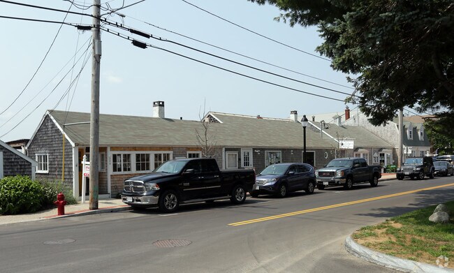
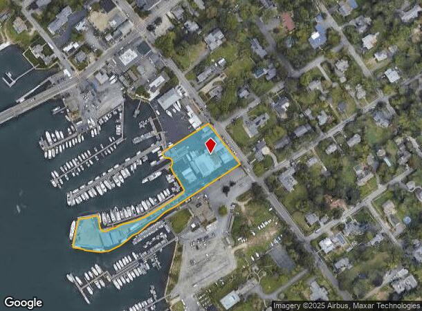
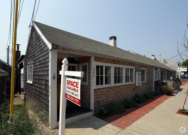
Property Record
242 Elm St, South Dartmouth, MA 02748
NEARBY LISTINGS FOR SALE OR LEASE
Property Detail
242 Elm St
DART-000112-000010
Bristol
Commercialnec
Massachusetts
VE
1.87 AC
25005C0479F
Attleboro/New Bedford
2025
Boston
2025
Providence-Warwick, RI-MA
653301
DEMOGRAPHICS near 242 Elm St
1 Mile
3 Mile
5 Mile
2024 Total Population
3,274
39,337
91,426
2029 Population
3,308
38,672
89,865
Pop Growth 2024-2029
+ 1.04%
(1.69%)
(1.71%)
Average Age
49
42
42
2024 Total Households
1,462
16,048
37,531
HH Growth 2024-2029
+ 1.03%
(1.72%)
(1.73%)
Median Household Inc
$126,838
$58,627
$57,185
Avg Household Size
2.20
2.40
2.30
2024 Avg HH Vehicles
2.00
2.00
2.00
Median Home Value
$530,545
$383,367
$359,423
Median Year Built
1956
1949
1949
Nearby Places
Map Layers
Map Styles
 Street
 Aerial
- Restaurants
- Banks
- Shops
- Fitness
- Groceries
PUBLIC TRANSPORTATION
AIRPORT
Rhode Island Tf Green International
DRIVE
WALK
Distance
Rhode Island Tf Green International
62 min
39.5 mi
Freight Ports
Port of New Bedford Harbor
DRIVE
WALK
Distance
Port of New Bedford Harbor
11 min
4.2 mi
SALE & LEASE HISTORY
LISTING DATE
SALE/LEASE

Aug 17, 2018
For Lease
Nearby Properties
Address
Land Use
TOTAL SIZE
Lot Size
Zoning
Address
Land Use
TOTAL SIZE
Lot Size
Zoning
10.29 AC
RA
Address
Land Use
TOTAL SIZE
Lot Size
Zoning
228,726 SF
5.51 AC
MUB
Address
Land Use
TOTAL SIZE
Lot Size
Zoning
265,000 SF
39.70 AC
SRB
Address
Land Use
TOTAL SIZE
Lot Size
Zoning
Address
Land Use
TOTAL SIZE
Lot Size
Zoning
5,716 SF
35.18 AC
GR
Address
Land Use
TOTAL SIZE
Lot Size
Zoning
5.59 AC
RC
Address
Land Use
TOTAL SIZE
Lot Size
Zoning
147,850 SF
2.50 AC
RC
Address
Land Use
TOTAL SIZE
Lot Size
Zoning
9.51 AC
SRA
Address
Land Use
TOTAL SIZE
Lot Size
Zoning
18.30 AC
RA
Address
Land Use
TOTAL SIZE
Lot Size
Zoning
30.17 AC
RB
Address
Land Use
TOTAL SIZE
Lot Size
Zoning
38.29 AC
RB
Address
Land Use
TOTAL SIZE
Lot Size
Zoning
8.30 AC
WI
Address
Land Use
TOTAL SIZE
Lot Size
Zoning
158,678 SF
3.11 AC
MUB
Address
Land Use
TOTAL SIZE
Lot Size
Zoning
76,014 SF
5.09 AC
GB
Address
Land Use
TOTAL SIZE
Lot Size
Zoning
83,357 SF
8.60 AC
GB
Address
Land Use
TOTAL SIZE
Lot Size
Zoning
79,972 SF
4.47 AC
RC
Address
Land Use
TOTAL SIZE
Lot Size
Zoning
51,516 SF
9 AC
RA
Address
Land Use
TOTAL SIZE
Lot Size
Zoning
Address
Land Use
TOTAL SIZE
Lot Size
Zoning
9.87 AC
RA
Address
Land Use
TOTAL SIZE
Lot Size
Zoning
77,537 SF
4.07 AC
RC
Address
Land Use
TOTAL SIZE
Lot Size
Zoning
63,186 SF
3.75 AC
RA
Address
Land Use
TOTAL SIZE
Lot Size
Zoning
8.29 AC
IB
Address
Land Use
TOTAL SIZE
Lot Size
Zoning
16.23 AC
RB
Address
Land Use
TOTAL SIZE
Lot Size
Zoning
3.27 AC
GR
Address
Land Use
TOTAL SIZE
Lot Size
Zoning
3.01 AC
SRB
Address
Land Use
TOTAL SIZE
Lot Size
Zoning
14.91 AC
SRA
Address
Land Use
TOTAL SIZE
Lot Size
Zoning
73,868 SF
8.42 AC
IB
Address
Land Use
TOTAL SIZE
Lot Size
Zoning
75,185 SF
4.84 AC
IB
Address
Land Use
TOTAL SIZE
Lot Size
Zoning
9.23 AC
IB
Address
Land Use
TOTAL SIZE
Lot Size
Zoning
1.95 AC
SRB
The World's #1 Commercial Real Estate Marketplace
Connect with us
© 2026 CoStar Group
The information above has been obtained from sources believed reliable. While we do not doubt its accuracy we have not verified it and make no guarantee, warranty or representation about it. It is your responsibility to independently confirm its accuracy and completeness. Any projections, opinions, assumptions, or estimates used are for example only and do not represent the current or future performance of the property. The value of this transaction to you depends on tax and other factors which should be evaluated by your tax, financial, and legal advisors. You and your advisors should conduct a careful, independent investigation of the property to determine to your satisfaction the suitability of the property for your needs.