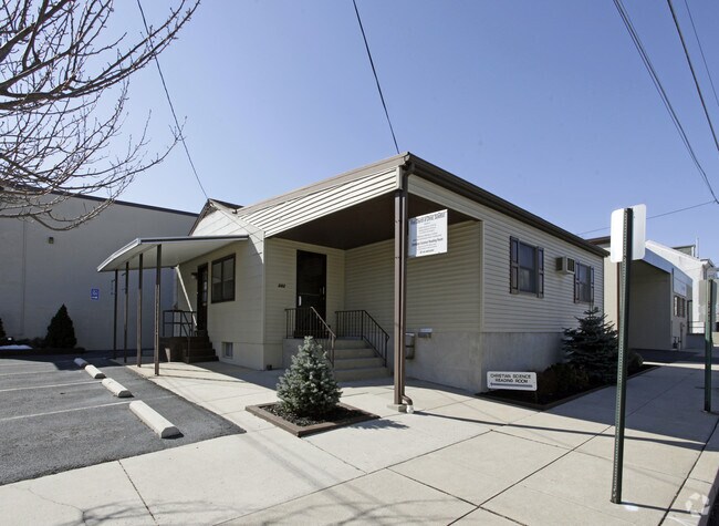
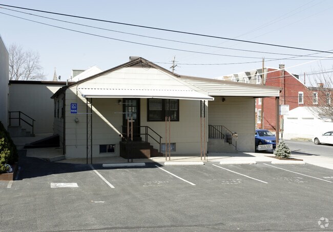
Property Record
242 Exeter St, Reading, PA 19601

Property Detail
242 Exeter St
14-5307-26-69-6397
Berks
Warehouse
Pennsylvania
B and X Area of moderate flood hazard, usually the area between the limits of the 100-year and 500-year floods.
0.35 AC
2025
Berks County
2025
Philadelphia
000400
Reading, PA
4,495 SF
NEARBY LISTINGS FOR SALE OR LEASE
DEMOGRAPHICS near 242 Exeter St
1 mile
3 mile
5 mile
2024 Total Population
20,184
126,322
200,620
2029 Population
20,382
128,539
204,652
Pop Growth 2024-2029
+ 0.98%
+ 1.76%
+ 2.01%
Average Age
35
37
39
2024 Total Households
6,754
44,909
73,884
HH Growth 2024-2029
+ 1.02%
+ 1.77%
+ 2.06%
Median Household Inc
$47,592
$53,051
$62,903
Avg Household Size
2.80
2.60
2.60
2024 Avg HH Vehicles
1.00
1.00
2.00
Median Home Value
$136,076
$165,705
$202,630
Median Year Built
1947
1949
1955
Nearby Places
Map Layers
Map Styles
 Street
 Aerial
Transit
 Traffic
 Biking
Places
Listings with unknown addresses are not visible on the map
- Restaurants
- Banks
- Shops
- Fitness
- Groceries
PUBLIC TRANSPORTATION
AIRPORT
Lehigh Valley International
Drive
Walk
Distance
Lehigh Valley International
58 min
38.4 mi
Freight Ports
Port of Wilmington, RI
Drive
Walk
Distance
Port of Wilmington, RI
90 min
59.9 mi
SALE & LEASE HISTORY
LISTING DATE
SALE/LEASE

Dec 05, 2017
For Lease
Nearby Properties
Address
Land Use
TOTAL SIZE
Lot Size
Zoning
Address
Land Use
TOTAL SIZE
Lot Size
Zoning
446,569 SF
81.02 AC
Address
Land Use
TOTAL SIZE
Lot Size
Zoning
33,761 SF
4.38 AC
Address
Land Use
TOTAL SIZE
Lot Size
Zoning
609,600 SF
37.91 AC
Address
Land Use
TOTAL SIZE
Lot Size
Zoning
99,065 SF
81.29 AC
Address
Land Use
TOTAL SIZE
Lot Size
Zoning
342,332 SF
3.30 AC
Address
Land Use
TOTAL SIZE
Lot Size
Zoning
144,696 SF
7.43 AC
Address
Land Use
TOTAL SIZE
Lot Size
Zoning
103.77 AC
Address
Land Use
TOTAL SIZE
Lot Size
Zoning
141,767 SF
124.26 AC
Address
Land Use
TOTAL SIZE
Lot Size
Zoning
250,600 SF
37.61 AC
Address
Land Use
TOTAL SIZE
Lot Size
Zoning
88,576 SF
1.80 AC
Address
Land Use
TOTAL SIZE
Lot Size
Zoning
386,194 SF
29.21 AC
Address
Land Use
TOTAL SIZE
Lot Size
Zoning
209,584 SF
24.33 AC
Address
Land Use
TOTAL SIZE
Lot Size
Zoning
139,946 SF
16.02 AC
Address
Land Use
TOTAL SIZE
Lot Size
Zoning
130,410 SF
23.02 AC
Address
Land Use
TOTAL SIZE
Lot Size
Zoning
45,138 SF
20.34 AC
Address
Land Use
TOTAL SIZE
Lot Size
Zoning
241,410 SF
44.78 AC
Address
Land Use
TOTAL SIZE
Lot Size
Zoning
80,864 SF
10.38 AC
Address
Land Use
TOTAL SIZE
Lot Size
Zoning
178,280 SF
19.15 AC
Address
Land Use
TOTAL SIZE
Lot Size
Zoning
104,559 SF
14.14 AC
Address
Land Use
TOTAL SIZE
Lot Size
Zoning
71,271 SF
1.42 AC
Address
Land Use
TOTAL SIZE
Lot Size
Zoning
174,046 SF
6.92 AC
Address
Land Use
TOTAL SIZE
Lot Size
Zoning
62,907 SF
5.25 AC
Address
Land Use
TOTAL SIZE
Lot Size
Zoning
116,788 SF
13.11 AC
Address
Land Use
TOTAL SIZE
Lot Size
Zoning
66,610 SF
5.38 AC
Address
Land Use
TOTAL SIZE
Lot Size
Zoning
27,055 SF
1.77 AC
Address
Land Use
TOTAL SIZE
Lot Size
Zoning
347,124 SF
19.93 AC
Address
Land Use
TOTAL SIZE
Lot Size
Zoning
158,736 SF
12.71 AC
Address
Land Use
TOTAL SIZE
Lot Size
Zoning
107,379 SF
3.30 AC
Address
Land Use
TOTAL SIZE
Lot Size
Zoning
295,427 SF
9.71 AC
Address
Land Use
TOTAL SIZE
Lot Size
Zoning
24,245 SF
4 AC
The World's #1 Commercial Real Estate Marketplace
Connect with us
© 2026 CoStar Group
The information above has been obtained from sources believed reliable. While we do not doubt its accuracy we have not verified it and make no guarantee, warranty or representation about it. It is your responsibility to independently confirm its accuracy and completeness. Any projections, opinions, assumptions, or estimates used are for example only and do not represent the current or future performance of the property. The value of this transaction to you depends on tax and other factors which should be evaluated by your tax, financial, and legal advisors. You and your advisors should conduct a careful, independent investigation of the property to determine to your satisfaction the suitability of the property for your needs.