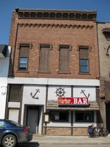
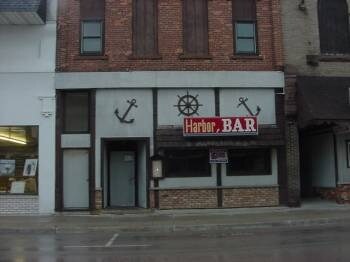
Property Record
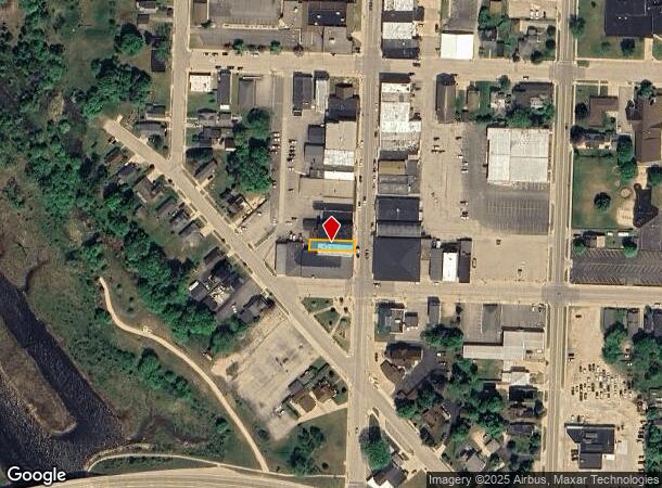
242 S Cedar St, Manistique, MI 49854
NEARBY LISTINGS FOR SALE OR LEASE
-
-
View all Manistique listings for sale on LoopNet.com
Property Detail
242 S Cedar St
Other Market Areas
Village Of Manistique
051-003-002-00
33 PRT OF LOT 1 BLK 3 OF VILL OF MANISTIQUE, BEG 60' N OF SE COR OF BLK 3, TH N 26', TH W 125', TH S 26', TH E 125' TO POB
Bartavern
Schoolcraft
2024
Michigan
2025
1
000300
0.07 AC
4,420 SF
Upper Peninsula
DEMOGRAPHICS near 242 S Cedar St
1 Mile
3 Mile
5 Mile
2024 Total Population
2,967
4,421
4,995
2029 Population
3,143
4,653
5,241
Pop Growth 2024-2029
+ 5.93%
+ 5.25%
+ 4.92%
Average Age
45
46
47
2024 Total Households
1,377
2,021
2,282
HH Growth 2024-2029
+ 6.03%
+ 5.24%
+ 4.95%
Median Household Inc
$46,143
$50,446
$51,702
Avg Household Size
2.10
2.10
2.10
2024 Avg HH Vehicles
2.00
2.00
2.00
Median Home Value
$93,231
$111,267
$125,292
Median Year Built
1978
1978
1979
Nearby Places
Map Layers
Map Styles
 Street
 Aerial
- Restaurants
- Banks
- Shops
- Fitness
- Groceries
Nearby Properties
Address
Land Use
TOTAL SIZE
Lot Size
Zoning
Address
Land Use
TOTAL SIZE
Lot Size
Zoning
44,076 SF
6.34 AC
M1 MIXED U
Address
Land Use
TOTAL SIZE
Lot Size
Zoning
17,430 SF
1.90 AC
B1 RES BUS
Address
Land Use
TOTAL SIZE
Lot Size
Zoning
15,155 SF
B2 GEN BUS
Address
Land Use
TOTAL SIZE
Lot Size
Zoning
241,519 SF
89.96 AC
I INDUSTRI
Address
Land Use
TOTAL SIZE
Lot Size
Zoning
8,189 SF
0.64 AC
B1 RES BUS
Address
Land Use
TOTAL SIZE
Lot Size
Zoning
8,500 SF
5.69 AC
B2 GEN BUS
Address
Land Use
TOTAL SIZE
Lot Size
Zoning
12,722 SF
2.01 AC
B2 GEN BUS
Address
Land Use
TOTAL SIZE
Lot Size
Zoning
19,650 SF
1.19 AC
B1 RES BUS
Address
Land Use
TOTAL SIZE
Lot Size
Zoning
32,500 SF
3.93 AC
B2 GEN BUS
Address
Land Use
TOTAL SIZE
Lot Size
Zoning
14,800 SF
2.52 AC
B2 GEN BUS
Address
Land Use
TOTAL SIZE
Lot Size
Zoning
1.10 AC
B1 RES BUS
Address
Land Use
TOTAL SIZE
Lot Size
Zoning
1.93 AC
B2 GEN BUS
Address
Land Use
TOTAL SIZE
Lot Size
Zoning
10,014 SF
2.96 AC
R 1 RESIDE
Address
Land Use
TOTAL SIZE
Lot Size
Zoning
16,704 SF
9 AC
Address
Land Use
TOTAL SIZE
Lot Size
Zoning
8.50 AC
B2 GEN BUS
Address
Land Use
TOTAL SIZE
Lot Size
Zoning
2,434 SF
18.98 AC
Address
Land Use
TOTAL SIZE
Lot Size
Zoning
1,560 SF
3 AC
B2 GEN BUS
Address
Land Use
TOTAL SIZE
Lot Size
Zoning
15,696 SF
1.99 AC
B2 GEN BUS
Address
Land Use
TOTAL SIZE
Lot Size
Zoning
1,660 SF
8.23 AC
B2 GEN BUS
Address
Land Use
TOTAL SIZE
Lot Size
Zoning
9,230 SF
1.18 AC
B2 GEN BUS
Address
Land Use
TOTAL SIZE
Lot Size
Zoning
Address
Land Use
TOTAL SIZE
Lot Size
Zoning
4,984 SF
10.70 AC
M1 MIXED U
Address
Land Use
TOTAL SIZE
Lot Size
Zoning
7,574 SF
1.99 AC
B2 GEN BUS
Address
Land Use
TOTAL SIZE
Lot Size
Zoning
600 AC
Address
Land Use
TOTAL SIZE
Lot Size
Zoning
3,600 SF
1.30 AC
M1 MIXED U
Address
Land Use
TOTAL SIZE
Lot Size
Zoning
Address
Land Use
TOTAL SIZE
Lot Size
Zoning
12,456 SF
0.32 AC
B1 RES BUS
Address
Land Use
TOTAL SIZE
Lot Size
Zoning
Address
Land Use
TOTAL SIZE
Lot Size
Zoning
Address
Land Use
TOTAL SIZE
Lot Size
Zoning
2,845 SF
2.04 AC
The World's #1 Commercial Real Estate Marketplace
Connect with us
© 2025 CoStar Group
The information above has been obtained from sources believed reliable. While we do not doubt its accuracy we have not verified it and make no guarantee, warranty or representation about it. It is your responsibility to independently confirm its accuracy and completeness. Any projections, opinions, assumptions, or estimates used are for example only and do not represent the current or future performance of the property. The value of this transaction to you depends on tax and other factors which should be evaluated by your tax, financial, and legal advisors. You and your advisors should conduct a careful, independent investigation of the property to determine to your satisfaction the suitability of the property for your needs.