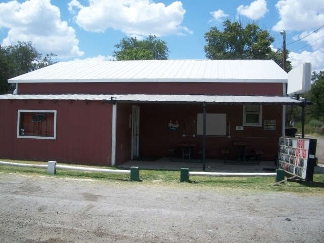
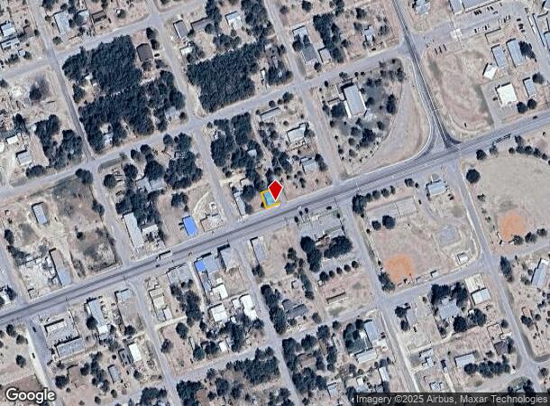
Property Record
242 W Us Highway 57 Hwy, La Pryor, TX 78872
NEARBY LISTINGS FOR SALE OR LEASE
-
-
View all La Pryor listings for sale on LoopNet.com
Property Detail
242 W Us Highway 57 Hwy
19176
LOT S60'(11&12) BLOCK 65 LA PRYOR
Restaurantbuilding
Zavala
2025
Texas
2025
0.07 AC
950200
Texas South Area
1,500 SF
Other Market Areas
DEMOGRAPHICS near 242 W Us Highway 57 Hwy
1 Mile
3 Mile
5 Mile
2024 Total Population
1,025
1,025
1,148
2029 Population
944
944
1,057
Pop Growth 2024-2029
(7.90%)
(7.90%)
(7.93%)
Average Age
38
38
38
2024 Total Households
362
362
406
HH Growth 2024-2029
(7.73%)
(7.73%)
(7.88%)
Median Household Inc
$36,018
$36,018
$36,166
Avg Household Size
2.80
2.80
2.80
2024 Avg HH Vehicles
2.00
2.00
2.00
Median Home Value
$66,444
$66,444
$66,468
Median Year Built
1986
1986
1986
Nearby Places
Map Layers
Map Styles
 Street
 Aerial
- Restaurants
- Banks
- Shops
- Fitness
- Groceries
Nearby Properties
Address
Land Use
TOTAL SIZE
Lot Size
Zoning
Address
Land Use
TOTAL SIZE
Lot Size
Zoning
11,354 SF
2.65 AC
Address
Land Use
TOTAL SIZE
Lot Size
Zoning
31,276 SF
2.46 AC
Address
Land Use
TOTAL SIZE
Lot Size
Zoning
28,061 SF
4 AC
Address
Land Use
TOTAL SIZE
Lot Size
Zoning
Address
Land Use
TOTAL SIZE
Lot Size
Zoning
6,088 SF
2.81 AC
Address
Land Use
TOTAL SIZE
Lot Size
Zoning
7,524 SF
2.65 AC
Address
Land Use
TOTAL SIZE
Lot Size
Zoning
4,000 SF
0.47 AC
Address
Land Use
TOTAL SIZE
Lot Size
Zoning
8,320 SF
1.26 AC
Address
Land Use
TOTAL SIZE
Lot Size
Zoning
2,719 SF
0.57 AC
Address
Land Use
TOTAL SIZE
Lot Size
Zoning
11,051 SF
0.95 AC
Address
Land Use
TOTAL SIZE
Lot Size
Zoning
6,350 SF
11.32 AC
Address
Land Use
TOTAL SIZE
Lot Size
Zoning
10,480 SF
2.64 AC
Address
Land Use
TOTAL SIZE
Lot Size
Zoning
2,720 SF
2.81 AC
Address
Land Use
TOTAL SIZE
Lot Size
Zoning
2,264 SF
2.81 AC
Address
Land Use
TOTAL SIZE
Lot Size
Zoning
3,500 SF
0.87 AC
Address
Land Use
TOTAL SIZE
Lot Size
Zoning
3,016 SF
1.33 AC
Address
Land Use
TOTAL SIZE
Lot Size
Zoning
5,040 SF
0.38 AC
Address
Land Use
TOTAL SIZE
Lot Size
Zoning
3,276 SF
0.19 AC
Address
Land Use
TOTAL SIZE
Lot Size
Zoning
130 AC
Address
Land Use
TOTAL SIZE
Lot Size
Zoning
2,010 SF
0.57 AC
Address
Land Use
TOTAL SIZE
Lot Size
Zoning
2.65 AC
Address
Land Use
TOTAL SIZE
Lot Size
Zoning
2,616 SF
1.33 AC
Address
Land Use
TOTAL SIZE
Lot Size
Zoning
80 AC
Address
Land Use
TOTAL SIZE
Lot Size
Zoning
4,866 SF
0.19 AC
Address
Land Use
TOTAL SIZE
Lot Size
Zoning
1,200 SF
Address
Land Use
TOTAL SIZE
Lot Size
Zoning
17.54 AC
Address
Land Use
TOTAL SIZE
Lot Size
Zoning
1,877 SF
0.57 AC
Address
Land Use
TOTAL SIZE
Lot Size
Zoning
2,206 SF
0.69 AC
Address
Land Use
TOTAL SIZE
Lot Size
Zoning
1,744 SF
0.47 AC
Address
Land Use
TOTAL SIZE
Lot Size
Zoning
2,048 SF
0.38 AC
The World's #1 Commercial Real Estate Marketplace
Connect with us
© 2026 CoStar Group
The information above has been obtained from sources believed reliable. While we do not doubt its accuracy we have not verified it and make no guarantee, warranty or representation about it. It is your responsibility to independently confirm its accuracy and completeness. Any projections, opinions, assumptions, or estimates used are for example only and do not represent the current or future performance of the property. The value of this transaction to you depends on tax and other factors which should be evaluated by your tax, financial, and legal advisors. You and your advisors should conduct a careful, independent investigation of the property to determine to your satisfaction the suitability of the property for your needs.