Property Record
242 Westgate Way, Florence, MT 59833
NEARBY LISTINGS FOR SALE OR LEASE
-
-
View all Florence listings for sale on LoopNet.com
Property Detail
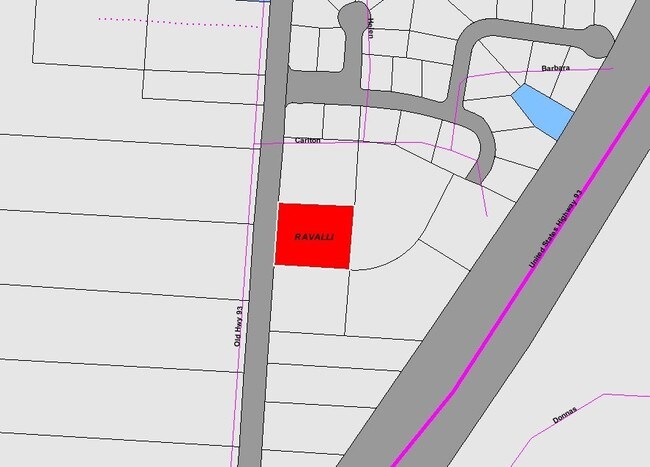
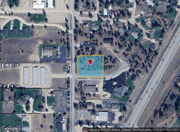
242 Westgate Way
Other Market Areas
Westgate Business Plaza
13-1869-11-4-03-01-0000
WESTGATE BUSINESS PLAZA, S11, T10 N, R20 W, ACRES 1.05, LOT 1
Commercialacreage
Ravalli
X
Montana
30063C1765E
1
2025
1.05 AC
2025
Montana Other Areas
000100
DEMOGRAPHICS near 242 Westgate Way
1 Mile
3 Mile
5 Mile
2024 Total Population
1,146
4,384
7,047
2029 Population
1,340
5,063
8,141
Pop Growth 2024-2029
+ 16.93%
+ 15.49%
+ 15.52%
Average Age
45
45
45
2024 Total Households
457
1,734
2,795
HH Growth 2024-2029
+ 16.85%
+ 15.51%
+ 15.53%
Median Household Inc
$71,086
$72,300
$72,822
Avg Household Size
2.40
2.50
2.50
2024 Avg HH Vehicles
3.00
3.00
3.00
Median Home Value
$448,750
$413,879
$393,716
Median Year Built
1989
1991
1991
Nearby Places
Map Layers
Map Styles
 Street
 Aerial
- Restaurants
- Banks
- Shops
- Fitness
- Groceries
PUBLIC TRANSPORTATION
AIRPORT
Missoula Montana
DRIVE
WALK
Distance
Missoula Montana
36 min
23.4 mi
Nearby Properties
Address
Land Use
TOTAL SIZE
Lot Size
Zoning
Address
Land Use
TOTAL SIZE
Lot Size
Zoning
8,000 SF
6.29 AC
Address
Land Use
TOTAL SIZE
Lot Size
Zoning
32,596 SF
2 AC
Address
Land Use
TOTAL SIZE
Lot Size
Zoning
11,250 SF
21.89 AC
Address
Land Use
TOTAL SIZE
Lot Size
Zoning
9,879 SF
2.01 AC
Address
Land Use
TOTAL SIZE
Lot Size
Zoning
8,375 SF
4.87 AC
Address
Land Use
TOTAL SIZE
Lot Size
Zoning
17,760 SF
4.63 AC
Address
Land Use
TOTAL SIZE
Lot Size
Zoning
7,414 SF
6.11 AC
Address
Land Use
TOTAL SIZE
Lot Size
Zoning
8,364 SF
4 AC
Address
Land Use
TOTAL SIZE
Lot Size
Zoning
14,422 SF
2.08 AC
Address
Land Use
TOTAL SIZE
Lot Size
Zoning
1,516 SF
0.71 AC
Address
Land Use
TOTAL SIZE
Lot Size
Zoning
11,184 SF
2.39 AC
Address
Land Use
TOTAL SIZE
Lot Size
Zoning
7,629 SF
1.15 AC
Address
Land Use
TOTAL SIZE
Lot Size
Zoning
4,074 SF
0.72 AC
Address
Land Use
TOTAL SIZE
Lot Size
Zoning
7,270 SF
2.04 AC
Address
Land Use
TOTAL SIZE
Lot Size
Zoning
6,559 SF
1 AC
Address
Land Use
TOTAL SIZE
Lot Size
Zoning
8,000 SF
1.28 AC
Address
Land Use
TOTAL SIZE
Lot Size
Zoning
4,216 SF
0.22 AC
Address
Land Use
TOTAL SIZE
Lot Size
Zoning
7,296 SF
1.73 AC
Address
Land Use
TOTAL SIZE
Lot Size
Zoning
9,122 SF
1.36 AC
Address
Land Use
TOTAL SIZE
Lot Size
Zoning
6,789 SF
1.02 AC
Address
Land Use
TOTAL SIZE
Lot Size
Zoning
Address
Land Use
TOTAL SIZE
Lot Size
Zoning
3,480 SF
0.78 AC
Address
Land Use
TOTAL SIZE
Lot Size
Zoning
4,190 SF
8.78 AC
Address
Land Use
TOTAL SIZE
Lot Size
Zoning
12,672 SF
1.18 AC
Address
Land Use
TOTAL SIZE
Lot Size
Zoning
2,583 SF
1 AC
Address
Land Use
TOTAL SIZE
Lot Size
Zoning
4,198 SF
1 AC
Address
Land Use
TOTAL SIZE
Lot Size
Zoning
4,798 SF
29.35 AC
Address
Land Use
TOTAL SIZE
Lot Size
Zoning
2,500 SF
2.32 AC
Address
Land Use
TOTAL SIZE
Lot Size
Zoning
2.19 AC
1
Address
Land Use
TOTAL SIZE
Lot Size
Zoning
3,456 SF
0.83 AC
The World's #1 Commercial Real Estate Marketplace
Connect with us
© 2025 CoStar Group
The information above has been obtained from sources believed reliable. While we do not doubt its accuracy we have not verified it and make no guarantee, warranty or representation about it. It is your responsibility to independently confirm its accuracy and completeness. Any projections, opinions, assumptions, or estimates used are for example only and do not represent the current or future performance of the property. The value of this transaction to you depends on tax and other factors which should be evaluated by your tax, financial, and legal advisors. You and your advisors should conduct a careful, independent investigation of the property to determine to your satisfaction the suitability of the property for your needs.