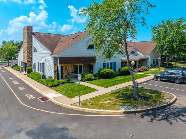
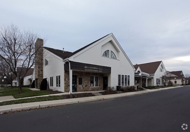
Property Record
2420 Bristol Rd, Bensalem, PA 19020
Current Lease Availabilities
NEARBY LISTINGS FOR SALE OR LEASE
Property Detail
2420 Bristol Rd
02-048-193-006
Unit 6 Neshaminy Vly Comm Ons Condo
Officebuilding
UNIT 6 NESHAMINY VLY COMM ONS CONDO 983.75SF
X
Bucks
42017C0443J
Pennsylvania
2024
0.02 AC
2025
Lower Bucks County
100206
Philadelphia
1,323 SF
Philadelphia-Camden-Wilmington, PA-NJ-DE-MD
DEMOGRAPHICS near 2420 Bristol Rd
1 Mile
3 Mile
5 Mile
2024 Total Population
13,389
95,745
241,856
2029 Population
13,399
95,352
239,246
Pop Growth 2024-2029
+ 0.07%
(0.41%)
(1.08%)
Average Age
43
42
42
2024 Total Households
4,959
36,667
91,341
HH Growth 2024-2029
+ 0.12%
(0.49%)
(1.18%)
Median Household Inc
$95,731
$76,391
$84,047
Avg Household Size
2.60
2.50
2.60
2024 Avg HH Vehicles
2.00
2.00
2.00
Median Home Value
$294,935
$305,750
$289,052
Median Year Built
1978
1972
1966
Nearby Places
Map Layers
Map Styles
 Street
 Aerial
- Restaurants
- Banks
- Shops
- Fitness
- Groceries
PUBLIC TRANSPORTATION
COMMUTER RAIL
Neshaminy Falls (R3 - Southeastern Pennsylvania Transportation Authority Regional Rail (SEPTA Regional Rail))
DRIVE
WALK
Distance
Neshaminy Falls (R3 - Southeastern Pennsylvania Transportation Authority Regional Rail (SEPTA Regional Rail))
6 min
2.4 mi
Langhorne (R3 - Southeastern Pennsylvania Transportation Authority Regional Rail (SEPTA Regional Rail))
DRIVE
WALK
Distance
Langhorne (R3 - Southeastern Pennsylvania Transportation Authority Regional Rail (SEPTA Regional Rail))
6 min
2.7 mi
AIRPORT
Trenton Mercer
DRIVE
WALK
Distance
Trenton Mercer
24 min
14.2 mi
Philadelphia International
DRIVE
WALK
Distance
Philadelphia International
46 min
30.0 mi
Freight Ports
Port of Philadelphia
DRIVE
WALK
Distance
Port of Philadelphia
26 min
16.3 mi
Nearby Properties
Address
Land Use
TOTAL SIZE
Lot Size
Zoning
Address
Land Use
TOTAL SIZE
Lot Size
Zoning
34,350 SF
336 AC
SPPOA
Address
Land Use
TOTAL SIZE
Lot Size
Zoning
410.98 AC
R2
Address
Land Use
TOTAL SIZE
Lot Size
Zoning
453,038 SF
34.79 AC
I1
Address
Land Use
TOTAL SIZE
Lot Size
Zoning
300,700 SF
30.41 AC
I1
Address
Land Use
TOTAL SIZE
Lot Size
Zoning
200.39 AC
SPPOP
Address
Land Use
TOTAL SIZE
Lot Size
Zoning
207,500 SF
16.18 AC
I1
Address
Land Use
TOTAL SIZE
Lot Size
Zoning
241,392 SF
24.15 AC
I1
Address
Land Use
TOTAL SIZE
Lot Size
Zoning
154,048 SF
15.74 AC
I1
Address
Land Use
TOTAL SIZE
Lot Size
Zoning
80,000 SF
7.07 AC
I1
Address
Land Use
TOTAL SIZE
Lot Size
Zoning
32,912 SF
42.06 AC
AO
Address
Land Use
TOTAL SIZE
Lot Size
Zoning
11,280 SF
26.16 AC
R3
Address
Land Use
TOTAL SIZE
Lot Size
Zoning
34,920 SF
38 AC
CD
Address
Land Use
TOTAL SIZE
Lot Size
Zoning
759,617 SF
23.82 AC
HC
Address
Land Use
TOTAL SIZE
Lot Size
Zoning
150,000 SF
21.46 AC
R3
Address
Land Use
TOTAL SIZE
Lot Size
Zoning
10,025 SF
19.11 AC
CD
Address
Land Use
TOTAL SIZE
Lot Size
Zoning
19.95 AC
CD
Address
Land Use
TOTAL SIZE
Lot Size
Zoning
202,400 SF
20.98 AC
C
Address
Land Use
TOTAL SIZE
Lot Size
Zoning
242,550 SF
24.32 AC
PI
Address
Land Use
TOTAL SIZE
Lot Size
Zoning
10,100 SF
18.52 AC
CD
Address
Land Use
TOTAL SIZE
Lot Size
Zoning
25,000 SF
18.52 AC
CD
Address
Land Use
TOTAL SIZE
Lot Size
Zoning
72,540 SF
14.02 AC
CD
Address
Land Use
TOTAL SIZE
Lot Size
Zoning
10,779 SF
19.07 AC
CD
Address
Land Use
TOTAL SIZE
Lot Size
Zoning
242,550 SF
24.18 AC
PI
Address
Land Use
TOTAL SIZE
Lot Size
Zoning
179,920 SF
23.92 AC
CS
Address
Land Use
TOTAL SIZE
Lot Size
Zoning
171,918 SF
17.70 AC
AO
Address
Land Use
TOTAL SIZE
Lot Size
Zoning
206,720 SF
0.97 AC
C
Address
Land Use
TOTAL SIZE
Lot Size
Zoning
555,218 SF
24.94 AC
M2
Address
Land Use
TOTAL SIZE
Lot Size
Zoning
281,600 SF
26.57 AC
PI
Address
Land Use
TOTAL SIZE
Lot Size
Zoning
41,546 SF
11.67 AC
CD
Address
Land Use
TOTAL SIZE
Lot Size
Zoning
199,758 SF
22.16 AC
HC
The World's #1 Commercial Real Estate Marketplace
Connect with us
© 2026 CoStar Group
The information above has been obtained from sources believed reliable. While we do not doubt its accuracy we have not verified it and make no guarantee, warranty or representation about it. It is your responsibility to independently confirm its accuracy and completeness. Any projections, opinions, assumptions, or estimates used are for example only and do not represent the current or future performance of the property. The value of this transaction to you depends on tax and other factors which should be evaluated by your tax, financial, and legal advisors. You and your advisors should conduct a careful, independent investigation of the property to determine to your satisfaction the suitability of the property for your needs.