Property Record
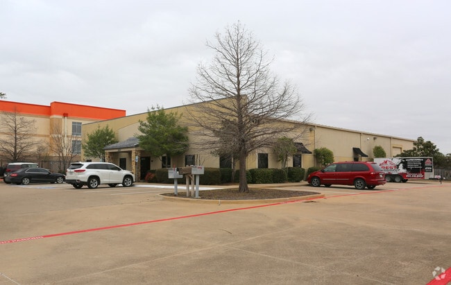
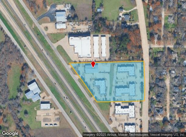
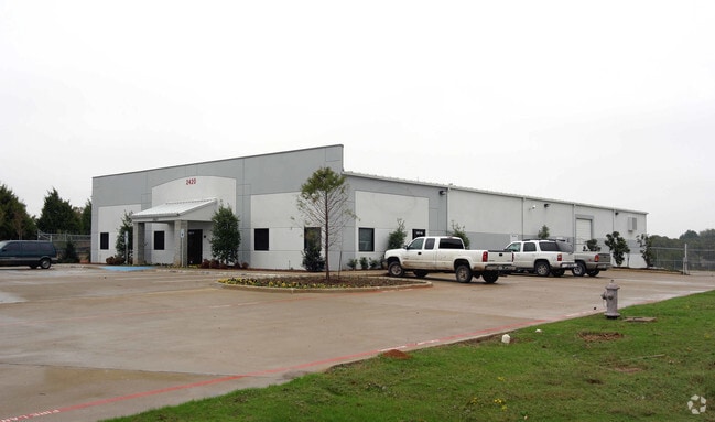
2420 Highway 287 N, Mansfield, TX 76063

NEARBY LISTINGS FOR SALE OR LEASE
Property Detail
2420 Highway 287 N
Dallas-Fort Worth-Arlington, TX
Osborn Addition
07614500
OSBORN ADDITION BLOCK 1 LOT 1 2 3 & 4A
Commercialnec
Tarrant
X
Texas
48251C0100J
1
2022
6.52 AC
2025
Mansfield
111406
Dallas/Ft Worth
57,030 SF
DEMOGRAPHICS near 2420 Highway 287 N
1 Mile
3 Mile
5 Mile
2024 Total Population
5,240
77,606
201,573
2029 Population
5,496
81,762
212,896
Pop Growth 2024-2029
+ 4.89%
+ 5.36%
+ 5.62%
Average Age
40
38
38
2024 Total Households
1,687
25,725
67,121
HH Growth 2024-2029
+ 4.98%
+ 5.47%
+ 5.66%
Median Household Inc
$126,223
$94,051
$91,333
Avg Household Size
3.00
3.00
2.90
2024 Avg HH Vehicles
2.00
2.00
2.00
Median Home Value
$344,936
$300,152
$281,164
Median Year Built
2001
1999
1996
Nearby Places
Map Layers
Map Styles
 Street
 Aerial
- Restaurants
- Banks
- Shops
- Fitness
- Groceries
PUBLIC TRANSPORTATION
AIRPORT
Dallas-Fort Worth International
DRIVE
WALK
Distance
Dallas-Fort Worth International
42 min
31.0 mi
Dallas Love Field
DRIVE
WALK
Distance
Dallas Love Field
51 min
39.6 mi
SALE & LEASE HISTORY
LISTING DATE
SALE/LEASE

Nov 14, 2016
For Lease
May 02, 2019
For Lease
Nearby Properties
Address
Land Use
TOTAL SIZE
Lot Size
Zoning
Address
Land Use
TOTAL SIZE
Lot Size
Zoning
348,951 SF
18.66 AC
Address
Land Use
TOTAL SIZE
Lot Size
Zoning
317,142 SF
11.40 AC
Address
Land Use
TOTAL SIZE
Lot Size
Zoning
160,000 SF
26.90 AC
Address
Land Use
TOTAL SIZE
Lot Size
Zoning
413,000 SF
19.16 AC
Address
Land Use
TOTAL SIZE
Lot Size
Zoning
298,988 SF
7.16 AC
Address
Land Use
TOTAL SIZE
Lot Size
Zoning
276,467 SF
7.61 AC
Address
Land Use
TOTAL SIZE
Lot Size
Zoning
246,204 SF
15.16 AC
Address
Land Use
TOTAL SIZE
Lot Size
Zoning
249,922 SF
17.26 AC
Address
Land Use
TOTAL SIZE
Lot Size
Zoning
255,134 SF
21.62 AC
Address
Land Use
TOTAL SIZE
Lot Size
Zoning
170,082 SF
36.49 AC
Address
Land Use
TOTAL SIZE
Lot Size
Zoning
724,286 SF
48.41 AC
Address
Land Use
TOTAL SIZE
Lot Size
Zoning
208,630 SF
8.62 AC
Address
Land Use
TOTAL SIZE
Lot Size
Zoning
214,444 SF
17.45 AC
Address
Land Use
TOTAL SIZE
Lot Size
Zoning
231,551 SF
25.69 AC
Address
Land Use
TOTAL SIZE
Lot Size
Zoning
171,820 SF
59.63 AC
Address
Land Use
TOTAL SIZE
Lot Size
Zoning
234,580 SF
65.82 AC
Address
Land Use
TOTAL SIZE
Lot Size
Zoning
169,347 SF
13.92 AC
Address
Land Use
TOTAL SIZE
Lot Size
Zoning
229,168 SF
6.13 AC
Address
Land Use
TOTAL SIZE
Lot Size
Zoning
399,496 SF
23.29 AC
Address
Land Use
TOTAL SIZE
Lot Size
Zoning
149,494 SF
3.73 AC
Address
Land Use
TOTAL SIZE
Lot Size
Zoning
79,070 SF
11.98 AC
Address
Land Use
TOTAL SIZE
Lot Size
Zoning
268,603 SF
12.45 AC
Address
Land Use
TOTAL SIZE
Lot Size
Zoning
275,337 SF
14 AC
Address
Land Use
TOTAL SIZE
Lot Size
Zoning
85,000 SF
13.03 AC
Address
Land Use
TOTAL SIZE
Lot Size
Zoning
158,103 SF
13.27 AC
Address
Land Use
TOTAL SIZE
Lot Size
Zoning
86,342 SF
12.15 AC
Address
Land Use
TOTAL SIZE
Lot Size
Zoning
1,300 SF
39.58 AC
Address
Land Use
TOTAL SIZE
Lot Size
Zoning
231,131 SF
0.99 AC
Address
Land Use
TOTAL SIZE
Lot Size
Zoning
84,455 SF
12.24 AC
Address
Land Use
TOTAL SIZE
Lot Size
Zoning
249,888 SF
11.57 AC
The World's #1 Commercial Real Estate Marketplace
Connect with us
© 2025 CoStar Group
The information above has been obtained from sources believed reliable. While we do not doubt its accuracy we have not verified it and make no guarantee, warranty or representation about it. It is your responsibility to independently confirm its accuracy and completeness. Any projections, opinions, assumptions, or estimates used are for example only and do not represent the current or future performance of the property. The value of this transaction to you depends on tax and other factors which should be evaluated by your tax, financial, and legal advisors. You and your advisors should conduct a careful, independent investigation of the property to determine to your satisfaction the suitability of the property for your needs.