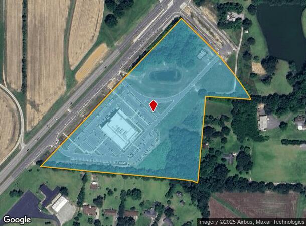
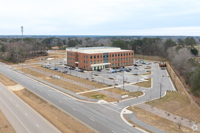
Property Record
2420 N Main St, Fuquay Varina, NC 27526

NEARBY LISTINGS FOR SALE OR LEASE
-
-
View all Fuquay Varina listings for sale on LoopNet.com
Property Detail
2420 N Main St
Raleigh/Durham
Wakemed Prop Serv Minor Sub
Raleigh, NC
LO3 WAKEMED PROP SERV MINOR SUB BM2022-0
0677.02-66-6661-000
Wake
Medicalbuilding
North Carolina
2024
3
2025
14.79 AC
053113
Southeast Wake County
83,283 SF
DEMOGRAPHICS near 2420 N Main St
1 Mile
3 Mile
5 Mile
2024 Total Population
3,046
30,976
92,413
2029 Population
3,376
34,128
101,716
Pop Growth 2024-2029
+ 10.83%
+ 10.18%
+ 10.07%
Average Age
40
39
39
2024 Total Households
1,113
11,038
32,530
HH Growth 2024-2029
+ 10.87%
+ 10.19%
+ 10.08%
Median Household Inc
$98,919
$98,505
$97,935
Avg Household Size
2.70
2.80
2.80
2024 Avg HH Vehicles
3.00
2.00
2.00
Median Home Value
$366,224
$367,888
$368,002
Median Year Built
2007
2004
2004
Nearby Places
Map Layers
Map Styles
 Street
 Aerial
- Restaurants
- Banks
- Shops
- Fitness
- Groceries
PUBLIC TRANSPORTATION
AIRPORT
Raleigh-Durham International
DRIVE
WALK
Distance
Raleigh-Durham International
38 min
25.1 mi
Freight Ports
Port of Wilmington
DRIVE
WALK
Distance
Port of Wilmington
150 min
126.0 mi
Nearby Properties
Address
Land Use
TOTAL SIZE
Lot Size
Zoning
Address
Land Use
TOTAL SIZE
Lot Size
Zoning
435,576 SF
29.37 AC
RHD-C
Address
Land Use
TOTAL SIZE
Lot Size
Zoning
207,800 SF
7.18 AC
NMU
Address
Land Use
TOTAL SIZE
Lot Size
Zoning
346,384 SF
56.12 AC
HI
Address
Land Use
TOTAL SIZE
Lot Size
Zoning
125,079 SF
15.15 AC
OI-CZ
Address
Land Use
TOTAL SIZE
Lot Size
Zoning
158,656 SF
10.31 AC
CC-CZ
Address
Land Use
TOTAL SIZE
Lot Size
Zoning
79,799 SF
25.53 AC
OI-CZ
Address
Land Use
TOTAL SIZE
Lot Size
Zoning
237,750 SF
41.18 AC
RLI
Address
Land Use
TOTAL SIZE
Lot Size
Zoning
105,035 SF
17.52 AC
O&I
Address
Land Use
TOTAL SIZE
Lot Size
Zoning
290,054 SF
34.18 AC
HI
Address
Land Use
TOTAL SIZE
Lot Size
Zoning
83,208 SF
27.68 AC
O&I
Address
Land Use
TOTAL SIZE
Lot Size
Zoning
101,680 SF
2.36 AC
UMU
Address
Land Use
TOTAL SIZE
Lot Size
Zoning
99,307 SF
10.91 AC
CC
Address
Land Use
TOTAL SIZE
Lot Size
Zoning
79,212 SF
4.10 AC
CC-CZ
Address
Land Use
TOTAL SIZE
Lot Size
Zoning
30,043 SF
12.77 AC
GC
Address
Land Use
TOTAL SIZE
Lot Size
Zoning
111,627 SF
2.55 AC
CC
Address
Land Use
TOTAL SIZE
Lot Size
Zoning
112,700 SF
15.84 AC
HI
Address
Land Use
TOTAL SIZE
Lot Size
Zoning
149,975 SF
18.73 AC
GC
Address
Land Use
TOTAL SIZE
Lot Size
Zoning
73,410 SF
21.97 AC
O&I
Address
Land Use
TOTAL SIZE
Lot Size
Zoning
183,855 SF
19.67 AC
HI
Address
Land Use
TOTAL SIZE
Lot Size
Zoning
69,135 SF
13.58 AC
RA
Address
Land Use
TOTAL SIZE
Lot Size
Zoning
130,000 SF
8 AC
CC-CZ
Address
Land Use
TOTAL SIZE
Lot Size
Zoning
56,940 SF
7.20 AC
GC
Address
Land Use
TOTAL SIZE
Lot Size
Zoning
107,689 SF
10.18 AC
CC
Address
Land Use
TOTAL SIZE
Lot Size
Zoning
85,396 SF
4.98 AC
RLI-C
Address
Land Use
TOTAL SIZE
Lot Size
Zoning
140,592 SF
10.04 AC
RLI
Address
Land Use
TOTAL SIZE
Lot Size
Zoning
1,120 SF
224.11 AC
RA
Address
Land Use
TOTAL SIZE
Lot Size
Zoning
48,333 SF
5.69 AC
CC
Address
Land Use
TOTAL SIZE
Lot Size
Zoning
59,914 SF
6.85 AC
RHD
Address
Land Use
TOTAL SIZE
Lot Size
Zoning
67,473 SF
5.16 AC
RHD
The World's #1 Commercial Real Estate Marketplace
Connect with us
© 2025 CoStar Group
The information above has been obtained from sources believed reliable. While we do not doubt its accuracy we have not verified it and make no guarantee, warranty or representation about it. It is your responsibility to independently confirm its accuracy and completeness. Any projections, opinions, assumptions, or estimates used are for example only and do not represent the current or future performance of the property. The value of this transaction to you depends on tax and other factors which should be evaluated by your tax, financial, and legal advisors. You and your advisors should conduct a careful, independent investigation of the property to determine to your satisfaction the suitability of the property for your needs.