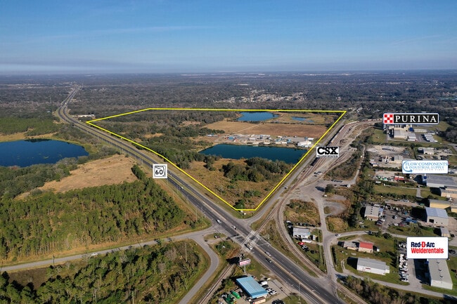
Property Record
2420 Old Highway 60, Mulberry, FL 33860
NEARBY LISTINGS FOR SALE OR LEASE
Property Detail
2420 Old Highway 60
23-30-03-000000-032010
Fuller Heights
Pasture
BEG SE COR OF NW1/4 RUN N 1470 FT FOR POB RUN W 118 FT S 380 FT W 2529 FT TO W-LINE SEC N 1550 FT TO N-LINE SEC E 2647 FT S 1170 FT TO POB
AE
Polk
12105C0490G
Florida
2024
38.39 AC
2025
Polk County
014905
Tampa/St Petersburg
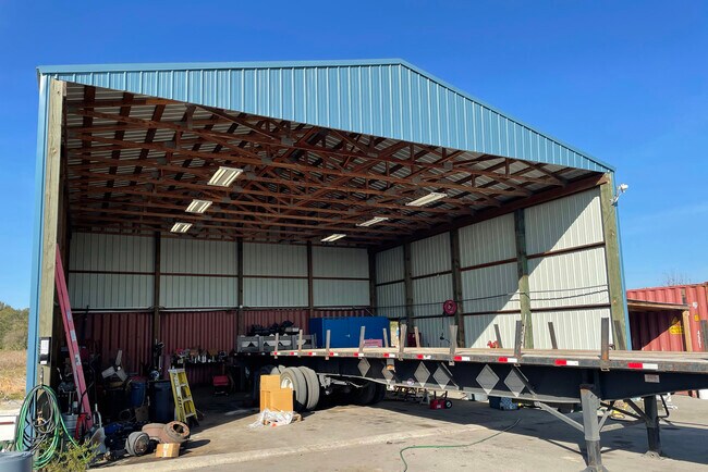
2,688 SF
Lakeland-Winter Haven, FL
DEMOGRAPHICS near 2420 Old Highway 60
1 mile
3 mile
5 mile
2024 Total Population
2,563
26,492
54,230
2029 Population
3,050
31,527
64,257
Pop Growth 2024-2029
+ 19.00%
+ 19.01%
+ 18.49%
Average Age
37
38
39
2024 Total Households
819
9,551
19,631
HH Growth 2024-2029
+ 18.93%
+ 18.94%
+ 18.48%
Median Household Inc
$57,676
$58,685
$70,352
Avg Household Size
2.80
2.70
2.70
2024 Avg HH Vehicles
2.00
2.00
2.00
Median Home Value
$180,480
$199,447
$248,030
Median Year Built
1993
1993
1993
Nearby Places
Map Layers
Map Styles
 Street
 Aerial
Transit
 Traffic
 Biking
Places
Listings with unknown addresses are not visible on the map
- Restaurants
- Banks
- Shops
- Fitness
- Groceries
SALE & LEASE HISTORY
LISTING DATE
SALE/LEASE

Feb 02, 2021
For Sale
Nearby Properties
Address
Land Use
TOTAL SIZE
Lot Size
Zoning
Address
Land Use
TOTAL SIZE
Lot Size
Zoning
882,663 SF
133.57 AC
PUD
Address
Land Use
TOTAL SIZE
Lot Size
Zoning
306,126 SF
25.03 AC
Address
Land Use
TOTAL SIZE
Lot Size
Zoning
9,069 SF
89.81 AC
R3
Address
Land Use
TOTAL SIZE
Lot Size
Zoning
5,534 SF
45.83 AC
GI
Address
Land Use
TOTAL SIZE
Lot Size
Zoning
214,889 SF
23.50 AC
Address
Land Use
TOTAL SIZE
Lot Size
Zoning
166,313 SF
63.97 AC
Address
Land Use
TOTAL SIZE
Lot Size
Zoning
126,269 SF
16.35 AC
Address
Land Use
TOTAL SIZE
Lot Size
Zoning
174,251 SF
26.66 AC
Address
Land Use
TOTAL SIZE
Lot Size
Zoning
9,036 SF
62.80 AC
RC
Address
Land Use
TOTAL SIZE
Lot Size
Zoning
145,672 SF
16 AC
Address
Land Use
TOTAL SIZE
Lot Size
Zoning
116,961 SF
5.01 AC
I1
Address
Land Use
TOTAL SIZE
Lot Size
Zoning
81,706 SF
20.35 AC
Address
Land Use
TOTAL SIZE
Lot Size
Zoning
66,800 SF
8.65 AC
Address
Land Use
TOTAL SIZE
Lot Size
Zoning
104,418 SF
20.10 AC
Address
Land Use
TOTAL SIZE
Lot Size
Zoning
79,100 SF
4.72 AC
PUD
Address
Land Use
TOTAL SIZE
Lot Size
Zoning
95,863 SF
8.10 AC
Address
Land Use
TOTAL SIZE
Lot Size
Zoning
103,698 SF
10.86 AC
GI
Address
Land Use
TOTAL SIZE
Lot Size
Zoning
48,882 SF
21.62 AC
Address
Land Use
TOTAL SIZE
Lot Size
Zoning
56,689 SF
9.30 AC
Address
Land Use
TOTAL SIZE
Lot Size
Zoning
88,138 SF
7.48 AC
Address
Land Use
TOTAL SIZE
Lot Size
Zoning
41,093 SF
1.58 AC
C1
Address
Land Use
TOTAL SIZE
Lot Size
Zoning
11,687 SF
9.95 AC
Address
Land Use
TOTAL SIZE
Lot Size
Zoning
50,303 SF
5.80 AC
Address
Land Use
TOTAL SIZE
Lot Size
Zoning
11,536 SF
10.31 AC
Address
Land Use
TOTAL SIZE
Lot Size
Zoning
27,580 SF
10.96 AC
RC
Address
Land Use
TOTAL SIZE
Lot Size
Zoning
59,860 SF
10.48 AC
GI
Address
Land Use
TOTAL SIZE
Lot Size
Zoning
68,151 SF
18.63 AC
Address
Land Use
TOTAL SIZE
Lot Size
Zoning
14,835 SF
8.96 AC
C2
Address
Land Use
TOTAL SIZE
Lot Size
Zoning
93,186 SF
2.67 AC
I1
Address
Land Use
TOTAL SIZE
Lot Size
Zoning
24,988 SF
8.28 AC
The World's #1 Commercial Real Estate Marketplace
Connect with us
© 2026 CoStar Group
The information above has been obtained from sources believed reliable. While we do not doubt its accuracy we have not verified it and make no guarantee, warranty or representation about it. It is your responsibility to independently confirm its accuracy and completeness. Any projections, opinions, assumptions, or estimates used are for example only and do not represent the current or future performance of the property. The value of this transaction to you depends on tax and other factors which should be evaluated by your tax, financial, and legal advisors. You and your advisors should conduct a careful, independent investigation of the property to determine to your satisfaction the suitability of the property for your needs.