Property Record
2420 Route 16, Ossipee, NH 03864
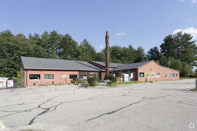

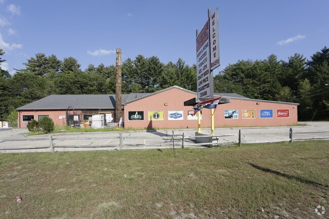
Property Detail
2420 Route 16
Commercialbuilding
CARROLL
COM
New Hampshire
B and X Area of moderate flood hazard, usually the area between the limits of the 100-year and 500-year floods.
9000
2024
2.40 AC
2024
Concord/New Hampshire North Area
955902
Other Market Areas
11,220 SF
OSSI-000007-000000-009000
NEARBY LISTINGS FOR SALE OR LEASE
-
-
View all Ossipee listings for lease on LoopNet.com
DEMOGRAPHICS near 2420 Route 16
1 mile
3 mile
5 mile
2025 Total Population
386
2,061
5,092
2030 Population
395
2,058
5,202
Pop Growth 2025-2030
+ 2.33%
(0.15%)
+ 2.16%
Average Age
49
49
50
2025 Total Households
182
961
2,454
HH Growth 2025-2030
+ 2.20%
0.00%
+ 2.65%
Median Household Inc
$86,693
$82,386
$74,619
Avg Household Size
2.10
2.10
2.00
2025 Avg HH Vehicles
2.00
2.00
2.00
Median Home Value
$392,999
$392,677
$394,599
Median Year Built
1976
1979
1982
Nearby Places
Map Layers
Map Styles
 Street
 Aerial
Transit
 Traffic
 Biking
Places
Listings with unknown addresses are not visible on the map
- Restaurants
- Banks
- Shops
- Fitness
- Groceries
SALE & LEASE HISTORY
LISTING DATE
SALE/LEASE

Sep 23, 2016
For Sale
Oct 17, 2017
For Lease
Mar 31, 2017
For Sale
Nearby Properties
Address
Land Use
TOTAL SIZE
Lot Size
Zoning
Address
Land Use
TOTAL SIZE
Lot Size
Zoning
390.81 AC
RUR OS
Address
Land Use
TOTAL SIZE
Lot Size
Zoning
53,838 SF
15 AC
TAMWOR
Address
Land Use
TOTAL SIZE
Lot Size
Zoning
26.90 AC
TAMWOR
Address
Land Use
TOTAL SIZE
Lot Size
Zoning
1,001 SF
25.80 AC
OSSIPE
Address
Land Use
TOTAL SIZE
Lot Size
Zoning
2,022 SF
51.77 AC
COMMER
Address
Land Use
TOTAL SIZE
Lot Size
Zoning
1,628 SF
902.70 AC
TAMWOR
Address
Land Use
TOTAL SIZE
Lot Size
Zoning
13,017 SF
116.50 AC
GENERA
Address
Land Use
TOTAL SIZE
Lot Size
Zoning
11,546 SF
5.11 AC
TAMWOR
Address
Land Use
TOTAL SIZE
Lot Size
Zoning
6,129 SF
29.50 AC
RUR
Address
Land Use
TOTAL SIZE
Lot Size
Zoning
22,103 SF
5.59 AC
COM
Address
Land Use
TOTAL SIZE
Lot Size
Zoning
19,271 SF
8 AC
RSC
Address
Land Use
TOTAL SIZE
Lot Size
Zoning
15,257 SF
3.50 AC
RSC
Address
Land Use
TOTAL SIZE
Lot Size
Zoning
1,911 SF
2.64 AC
RURAL
Address
Land Use
TOTAL SIZE
Lot Size
Zoning
1,298 SF
2.86 AC
TAMWOR
Address
Land Use
TOTAL SIZE
Lot Size
Zoning
1,720 SF
186.40 AC
TAMWOR
Address
Land Use
TOTAL SIZE
Lot Size
Zoning
1,376 SF
1 AC
RURAL
Address
Land Use
TOTAL SIZE
Lot Size
Zoning
4,340 SF
0.97 AC
OSSIPE
Address
Land Use
TOTAL SIZE
Lot Size
Zoning
38 AC
TAMWOR
Address
Land Use
TOTAL SIZE
Lot Size
Zoning
1,744 SF
1.10 AC
RURAL
Address
Land Use
TOTAL SIZE
Lot Size
Zoning
1.50 AC
RURAL
Address
Land Use
TOTAL SIZE
Lot Size
Zoning
1,299 SF
0.50 AC
RURAL
Address
Land Use
TOTAL SIZE
Lot Size
Zoning
2,301 SF
3.06 AC
OSSIPE
Address
Land Use
TOTAL SIZE
Lot Size
Zoning
1,387 SF
0.75 AC
RURAL
Address
Land Use
TOTAL SIZE
Lot Size
Zoning
0.59 AC
TAMWOR
Address
Land Use
TOTAL SIZE
Lot Size
Zoning
28,588 SF
2.50 AC
TAMWOR
Address
Land Use
TOTAL SIZE
Lot Size
Zoning
3,000 SF
5.34 AC
TAMWOR
Address
Land Use
TOTAL SIZE
Lot Size
Zoning
1.50 AC
RSC
Address
Land Use
TOTAL SIZE
Lot Size
Zoning
5,089 SF
9.91 AC
TAMWOR
Address
Land Use
TOTAL SIZE
Lot Size
Zoning
0.61 AC
RURAL
The World's #1 Commercial Real Estate Marketplace
Connect with us
© 2026 CoStar Group
The information above has been obtained from sources believed reliable. While we do not doubt its accuracy we have not verified it and make no guarantee, warranty or representation about it. It is your responsibility to independently confirm its accuracy and completeness. Any projections, opinions, assumptions, or estimates used are for example only and do not represent the current or future performance of the property. The value of this transaction to you depends on tax and other factors which should be evaluated by your tax, financial, and legal advisors. You and your advisors should conduct a careful, independent investigation of the property to determine to your satisfaction the suitability of the property for your needs.