Property Record
2420 Sw 45Th Ave, Amarillo, TX 79110

NEARBY LISTINGS FOR SALE OR LEASE
Property Detail
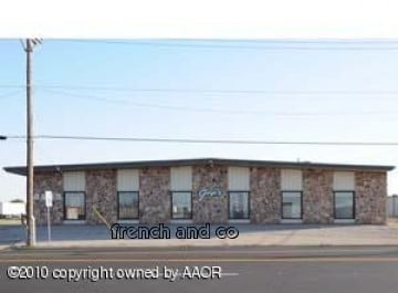
2420 Sw 45Th Ave
Amarillo, TX
45Th-Georgia Sub # 15
R-022-6200-0705-0
45TH-GEORGIA SUB # 15, TR 10A
Warehouse
Randall
AE
Texas
48375C0540C
10a
2024
0.80 AC
2025
Amarillo
020900
Other Market Areas
6,400 SF
DEMOGRAPHICS near 2420 Sw 45Th Ave
1 Mile
3 Mile
5 Mile
2024 Total Population
14,672
88,252
164,680
2029 Population
16,055
93,811
172,996
Pop Growth 2024-2029
+ 9.43%
+ 6.30%
+ 5.05%
Average Age
38
38
38
2024 Total Households
6,132
36,573
67,098
HH Growth 2024-2029
+ 9.92%
+ 6.30%
+ 5.10%
Median Household Inc
$50,714
$57,326
$57,647
Avg Household Size
2.30
2.30
2.40
2024 Avg HH Vehicles
2.00
2.00
2.00
Median Home Value
$126,303
$159,817
$165,783
Median Year Built
1967
1970
1973
Nearby Places
Map Layers
Map Styles
 Street
 Aerial
- Restaurants
- Banks
- Shops
- Fitness
- Groceries
PUBLIC TRANSPORTATION
AIRPORT
Rick Husband Amarillo International
DRIVE
WALK
Distance
Rick Husband Amarillo International
22 min
12.3 mi
Nearby Properties
Address
Land Use
TOTAL SIZE
Lot Size
Zoning
Address
Land Use
TOTAL SIZE
Lot Size
Zoning
431,320 SF
14.82 AC
1F2 S
Address
Land Use
TOTAL SIZE
Lot Size
Zoning
342,930 SF
34.57 AC
PD
Address
Land Use
TOTAL SIZE
Lot Size
Zoning
112,261 SF
21.82 AC
Address
Land Use
TOTAL SIZE
Lot Size
Zoning
168,978 SF
4.23 AC
1F2 S
Address
Land Use
TOTAL SIZE
Lot Size
Zoning
207,120 SF
16.54 AC
GR
Address
Land Use
TOTAL SIZE
Lot Size
Zoning
345,555 SF
23.69 AC
PD
Address
Land Use
TOTAL SIZE
Lot Size
Zoning
116,842 SF
4.17 AC
Address
Land Use
TOTAL SIZE
Lot Size
Zoning
254,693 SF
5.24 AC
LC
Address
Land Use
TOTAL SIZE
Lot Size
Zoning
145,652 SF
20.53 AC
Address
Land Use
TOTAL SIZE
Lot Size
Zoning
168,130 SF
16.32 AC
Address
Land Use
TOTAL SIZE
Lot Size
Zoning
182,242 SF
20.70 AC
Address
Land Use
TOTAL SIZE
Lot Size
Zoning
210,217 SF
10.49 AC
M11
Address
Land Use
TOTAL SIZE
Lot Size
Zoning
74,960 SF
7 AC
R2
Address
Land Use
TOTAL SIZE
Lot Size
Zoning
125,357 SF
4.34 AC
LC
Address
Land Use
TOTAL SIZE
Lot Size
Zoning
204,468 SF
17.56 AC
Address
Land Use
TOTAL SIZE
Lot Size
Zoning
80,298 SF
7.75 AC
Address
Land Use
TOTAL SIZE
Lot Size
Zoning
99,739 SF
3.88 AC
R2
Address
Land Use
TOTAL SIZE
Lot Size
Zoning
167,257 SF
12.66 AC
Address
Land Use
TOTAL SIZE
Lot Size
Zoning
112,005 SF
7.70 AC
GR
Address
Land Use
TOTAL SIZE
Lot Size
Zoning
110,796 SF
0.55 AC
MF2
Address
Land Use
TOTAL SIZE
Lot Size
Zoning
276,741 SF
10.07 AC
GR
Address
Land Use
TOTAL SIZE
Lot Size
Zoning
169,056 SF
2.35 AC
MF2
Address
Land Use
TOTAL SIZE
Lot Size
Zoning
183,758 SF
16.74 AC
R2
Address
Land Use
TOTAL SIZE
Lot Size
Zoning
132,914 SF
10.20 AC
PD
Address
Land Use
TOTAL SIZE
Lot Size
Zoning
205,577 SF
18.68 AC
I1
Address
Land Use
TOTAL SIZE
Lot Size
Zoning
185,895 SF
9.59 AC
Address
Land Use
TOTAL SIZE
Lot Size
Zoning
172,531 SF
10.37 AC
LC
Address
Land Use
TOTAL SIZE
Lot Size
Zoning
72,387 SF
5.08 AC
Address
Land Use
TOTAL SIZE
Lot Size
Zoning
297,246 SF
13.91 AC
MF1
Address
Land Use
TOTAL SIZE
Lot Size
Zoning
187,253 SF
9.69 AC
PD
The World's #1 Commercial Real Estate Marketplace
Connect with us
© 2026 CoStar Group
The information above has been obtained from sources believed reliable. While we do not doubt its accuracy we have not verified it and make no guarantee, warranty or representation about it. It is your responsibility to independently confirm its accuracy and completeness. Any projections, opinions, assumptions, or estimates used are for example only and do not represent the current or future performance of the property. The value of this transaction to you depends on tax and other factors which should be evaluated by your tax, financial, and legal advisors. You and your advisors should conduct a careful, independent investigation of the property to determine to your satisfaction the suitability of the property for your needs.