Property Record
2420 W State Highway Cc, Ozark, MO 65721
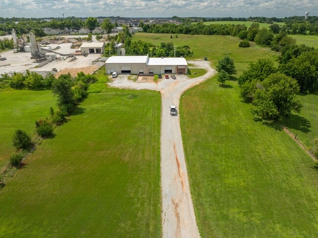
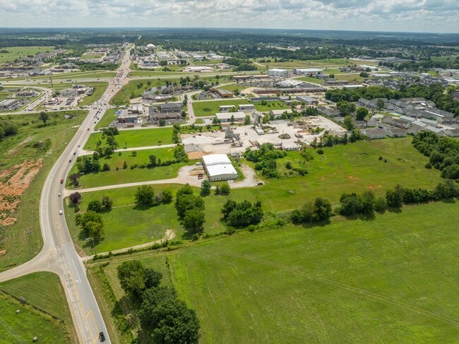
This Property Is For Sale
NEARBY LISTINGS FOR SALE OR LEASE
Property Detail
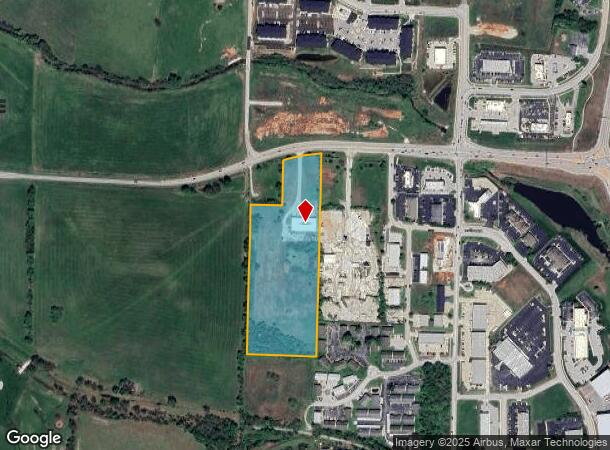
2420 W State Highway Cc
11-0.2-04-000-000-064.004
Ozark, City Of In
Officebuilding
E 435 NW SE LYING S OF CC.
X
Christian
29043C0078D
Missouri
2024
11 AC
2025
West Christian County
020307
Springfield
1,320 SF
Springfield, MO
DEMOGRAPHICS near 2420 W State Highway Cc
1 mile
3 mile
5 mile
2024 Total Population
4,464
28,503
74,960
2029 Population
5,433
34,117
87,458
Pop Growth 2024-2029
+ 21.71%
+ 19.70%
+ 16.67%
Average Age
39
39
40
2024 Total Households
1,814
10,863
29,103
HH Growth 2024-2029
+ 21.78%
+ 19.76%
+ 16.49%
Median Household Inc
$58,831
$80,218
$76,998
Avg Household Size
2.40
2.60
2.50
2024 Avg HH Vehicles
2.00
2.00
2.00
Median Home Value
$268,269
$264,251
$240,645
Median Year Built
2004
2003
1997
Nearby Places
Map Layers
Map Styles
 Street
 Aerial
Transit
 Traffic
 Biking
Places
Listings with unknown addresses are not visible on the map
- Restaurants
- Banks
- Shops
- Fitness
- Groceries
PUBLIC TRANSPORTATION
AIRPORT
Springfield-Branson Ntl
Drive
Walk
Distance
Springfield-Branson Ntl
38 min
26.1 mi
Nearby Properties
Address
Land Use
TOTAL SIZE
Lot Size
Zoning
Address
Land Use
TOTAL SIZE
Lot Size
Zoning
2,400 SF
41.33 AC
Address
Land Use
TOTAL SIZE
Lot Size
Zoning
1,632 SF
12 AC
Address
Land Use
TOTAL SIZE
Lot Size
Zoning
8.08 AC
INC
Address
Land Use
TOTAL SIZE
Lot Size
Zoning
13,048 SF
9.29 AC
Address
Land Use
TOTAL SIZE
Lot Size
Zoning
6,000 SF
50.60 AC
Address
Land Use
TOTAL SIZE
Lot Size
Zoning
129,257 SF
32 AC
Address
Land Use
TOTAL SIZE
Lot Size
Zoning
13.11 AC
INC
Address
Land Use
TOTAL SIZE
Lot Size
Zoning
1,588 SF
73.78 AC
Address
Land Use
TOTAL SIZE
Lot Size
Zoning
1,836 SF
35.65 AC
Address
Land Use
TOTAL SIZE
Lot Size
Zoning
3,942 SF
40 AC
Address
Land Use
TOTAL SIZE
Lot Size
Zoning
9,474 SF
8.90 AC
Address
Land Use
TOTAL SIZE
Lot Size
Zoning
68,882 SF
39.87 AC
Address
Land Use
TOTAL SIZE
Lot Size
Zoning
3,025 SF
2.20 AC
Address
Land Use
TOTAL SIZE
Lot Size
Zoning
968 SF
18.67 AC
Address
Land Use
TOTAL SIZE
Lot Size
Zoning
54.39 AC
INC
Address
Land Use
TOTAL SIZE
Lot Size
Zoning
11,421 SF
163.10 AC
Address
Land Use
TOTAL SIZE
Lot Size
Zoning
9,841 SF
7.17 AC
Address
Land Use
TOTAL SIZE
Lot Size
Zoning
3,910 SF
6.33 AC
Address
Land Use
TOTAL SIZE
Lot Size
Zoning
92,462 SF
19.78 AC
Address
Land Use
TOTAL SIZE
Lot Size
Zoning
7,472 SF
4.51 AC
Address
Land Use
TOTAL SIZE
Lot Size
Zoning
5,184 SF
5.30 AC
Address
Land Use
TOTAL SIZE
Lot Size
Zoning
8,933 SF
8.64 AC
Address
Land Use
TOTAL SIZE
Lot Size
Zoning
16.23 AC
INC
Address
Land Use
TOTAL SIZE
Lot Size
Zoning
5,824 SF
6.68 AC
Address
Land Use
TOTAL SIZE
Lot Size
Zoning
3,003 SF
6.46 AC
Address
Land Use
TOTAL SIZE
Lot Size
Zoning
20,765 SF
3 AC
Address
Land Use
TOTAL SIZE
Lot Size
Zoning
9,285 SF
5.49 AC
Address
Land Use
TOTAL SIZE
Lot Size
Zoning
5,760 SF
8.62 AC
Address
Land Use
TOTAL SIZE
Lot Size
Zoning
4,545 SF
4.16 AC
Address
Land Use
TOTAL SIZE
Lot Size
Zoning
20,708 SF
31.97 AC
INC
The World's #1 Commercial Real Estate Marketplace
Connect with us
© 2026 CoStar Group
The information above has been obtained from sources believed reliable. While we do not doubt its accuracy we have not verified it and make no guarantee, warranty or representation about it. It is your responsibility to independently confirm its accuracy and completeness. Any projections, opinions, assumptions, or estimates used are for example only and do not represent the current or future performance of the property. The value of this transaction to you depends on tax and other factors which should be evaluated by your tax, financial, and legal advisors. You and your advisors should conduct a careful, independent investigation of the property to determine to your satisfaction the suitability of the property for your needs.