Property Record
2420 Z St, Omaha, NE 68107


NEARBY LISTINGS FOR SALE OR LEASE
Property Detail
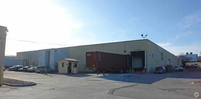
2420 Z St
Omaha-Council Bluffs, NE-IA
Albright Annex
0734-0010-05
ALBRIGHT ANNEX LOT 28 BLOCK 16 IRR N 188 S 360 E 362.54 W 482.54 FT & IRR S 172 W 356 FT TL 22 SW1/4 NW1/4 SEC 10-14-13 & VAC Y ST & VAC ALLEY ADJ & ALL LTS 7 THRU 20 & LTS 27 & 28 BLK 16 5.25AC
Warehouse
Douglas
X
Nebraska
31153C0080G
28
2024
5.26 AC
2025
Southeast Omaha
002900
Omaha/Council Bluffs
111,265 SF
DEMOGRAPHICS near 2420 Z St
1 Mile
3 Mile
5 Mile
2024 Total Population
15,304
80,810
214,310
2029 Population
15,602
82,956
221,808
Pop Growth 2024-2029
+ 1.95%
+ 2.66%
+ 3.50%
Average Age
33
36
36
2024 Total Households
4,634
27,533
85,456
HH Growth 2024-2029
+ 2.11%
+ 2.83%
+ 3.66%
Median Household Inc
$50,913
$57,693
$58,146
Avg Household Size
3.10
2.80
2.40
2024 Avg HH Vehicles
2.00
2.00
2.00
Median Home Value
$122,082
$157,069
$180,520
Median Year Built
1949
1957
1965
Nearby Places
Map Layers
Map Styles
 Street
 Aerial
- Restaurants
- Banks
- Shops
- Fitness
- Groceries
PUBLIC TRANSPORTATION
COMMUTER RAIL
DRIVE
WALK
Distance
10 min
4.7 mi
DRIVE
WALK
Distance
11 min
4.9 mi
AIRPORT
Eppley Airfield
DRIVE
WALK
Distance
Eppley Airfield
19 min
9.6 mi
SALE & LEASE HISTORY
LISTING DATE
SALE/LEASE

Apr 11, 2017
For Lease
Nearby Properties
Address
Land Use
TOTAL SIZE
Lot Size
Zoning
Address
Land Use
TOTAL SIZE
Lot Size
Zoning
276,509 SF
3.67 AC
Address
Land Use
TOTAL SIZE
Lot Size
Zoning
1,216 SF
22.82 AC
Address
Land Use
TOTAL SIZE
Lot Size
Zoning
12.71 AC
Address
Land Use
TOTAL SIZE
Lot Size
Zoning
119,396 SF
13.46 AC
Address
Land Use
TOTAL SIZE
Lot Size
Zoning
226,320 SF
12.75 AC
Address
Land Use
TOTAL SIZE
Lot Size
Zoning
1,850 SF
8.14 AC
Address
Land Use
TOTAL SIZE
Lot Size
Zoning
400 SF
23.26 AC
Address
Land Use
TOTAL SIZE
Lot Size
Zoning
42,900 SF
16.25 AC
Address
Land Use
TOTAL SIZE
Lot Size
Zoning
212,990 SF
8.75 AC
MH
Address
Land Use
TOTAL SIZE
Lot Size
Zoning
193,967 SF
7.27 AC
Address
Land Use
TOTAL SIZE
Lot Size
Zoning
236,067 SF
10.12 AC
HI
Address
Land Use
TOTAL SIZE
Lot Size
Zoning
33,713 SF
14.39 AC
Address
Land Use
TOTAL SIZE
Lot Size
Zoning
4.53 AC
Address
Land Use
TOTAL SIZE
Lot Size
Zoning
270,446 SF
13.68 AC
R7
Address
Land Use
TOTAL SIZE
Lot Size
Zoning
126,910 SF
13.49 AC
Address
Land Use
TOTAL SIZE
Lot Size
Zoning
173,616 SF
9.30 AC
Address
Land Use
TOTAL SIZE
Lot Size
Zoning
3,418 SF
5.56 AC
Address
Land Use
TOTAL SIZE
Lot Size
Zoning
230,995 SF
11.29 AC
HI
Address
Land Use
TOTAL SIZE
Lot Size
Zoning
3.41 AC
A-P
Address
Land Use
TOTAL SIZE
Lot Size
Zoning
252,694 SF
17.74 AC
HI
Address
Land Use
TOTAL SIZE
Lot Size
Zoning
116,718 SF
8.28 AC
Address
Land Use
TOTAL SIZE
Lot Size
Zoning
161,765 SF
18.32 AC
Address
Land Use
TOTAL SIZE
Lot Size
Zoning
38,595 SF
2.07 AC
Address
Land Use
TOTAL SIZE
Lot Size
Zoning
74,586 SF
4.24 AC
Address
Land Use
TOTAL SIZE
Lot Size
Zoning
85,320 SF
6.60 AC
HI
Address
Land Use
TOTAL SIZE
Lot Size
Zoning
81,172 SF
4 AC
Address
Land Use
TOTAL SIZE
Lot Size
Zoning
1,768 SF
14.80 AC
Address
Land Use
TOTAL SIZE
Lot Size
Zoning
139,236 SF
8.19 AC
Address
Land Use
TOTAL SIZE
Lot Size
Zoning
273,738 SF
16.07 AC
Address
Land Use
TOTAL SIZE
Lot Size
Zoning
252,050 SF
10.62 AC
The World's #1 Commercial Real Estate Marketplace
Connect with us
© 2026 CoStar Group
The information above has been obtained from sources believed reliable. While we do not doubt its accuracy we have not verified it and make no guarantee, warranty or representation about it. It is your responsibility to independently confirm its accuracy and completeness. Any projections, opinions, assumptions, or estimates used are for example only and do not represent the current or future performance of the property. The value of this transaction to you depends on tax and other factors which should be evaluated by your tax, financial, and legal advisors. You and your advisors should conduct a careful, independent investigation of the property to determine to your satisfaction the suitability of the property for your needs.