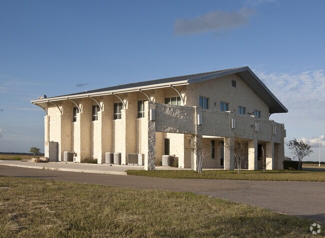
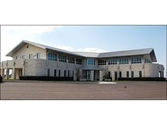
Property Record
24200 N Fm 509, Harlingen, TX 78550

NEARBY LISTINGS FOR SALE OR LEASE
-
-
View all Harlingen listings for sale on LoopNet.com
Property Detail
24200 N Fm 509
982080-0230-001000
Palmetal Co Subdivision
Taxexempt
PALMETAL CO SUBDIVISION BLK 23, 14.52 ACS OUT OF 40.00 ACRES
X
Cameron
48061C0260F
Texas
0
14.52 AC
2025
Outlying Cameron County
010802
Brownsville/Harlingen
16,694 SF
Brownsville-Harlingen, TX
DEMOGRAPHICS near 24200 N Fm 509
1 Mile
3 Mile
5 Mile
2024 Total Population
89
19,101
69,549
2029 Population
100
19,706
70,997
Pop Growth 2024-2029
+ 12.36%
+ 3.17%
+ 2.08%
Average Age
32
36
37
2024 Total Households
18
6,718
23,829
HH Growth 2024-2029
+ 16.67%
+ 2.99%
+ 2.02%
Median Household Inc
$24,999
$59,210
$46,450
Avg Household Size
2.60
2.70
2.80
2024 Avg HH Vehicles
1.00
2.00
2.00
Median Home Value
$99,999
$127,048
$98,318
Median Year Built
2009
1987
1983
Nearby Places
Map Layers
Map Styles
 Street
 Aerial
- Restaurants
- Banks
- Shops
- Fitness
- Groceries
PUBLIC TRANSPORTATION
AIRPORT
Valley International
DRIVE
WALK
Distance
Valley International
7 min
2.1 mi
Brownsville/South Padre Island International
DRIVE
WALK
Distance
Brownsville/South Padre Island International
43 min
29.1 mi
Freight Ports
Port of Brownsville
DRIVE
WALK
Distance
Port of Brownsville
36 min
26.7 mi
Nearby Properties
Address
Land Use
TOTAL SIZE
Lot Size
Zoning
Address
Land Use
TOTAL SIZE
Lot Size
Zoning
663,572 SF
60.74 AC
I
Address
Land Use
TOTAL SIZE
Lot Size
Zoning
100,090 SF
15 AC
Address
Land Use
TOTAL SIZE
Lot Size
Zoning
134,518 SF
10.01 AC
Address
Land Use
TOTAL SIZE
Lot Size
Zoning
16,508 SF
347.82 AC
Address
Land Use
TOTAL SIZE
Lot Size
Zoning
20,062 SF
47.54 AC
C
Address
Land Use
TOTAL SIZE
Lot Size
Zoning
180,838 SF
12.56 AC
C
Address
Land Use
TOTAL SIZE
Lot Size
Zoning
176,627 SF
12.45 AC
A-C
Address
Land Use
TOTAL SIZE
Lot Size
Zoning
84,936 SF
12 AC
Address
Land Use
TOTAL SIZE
Lot Size
Zoning
188,102 SF
45.81 AC
C
Address
Land Use
TOTAL SIZE
Lot Size
Zoning
93,459 SF
20 AC
Address
Land Use
TOTAL SIZE
Lot Size
Zoning
7,600 SF
16.94 AC
Address
Land Use
TOTAL SIZE
Lot Size
Zoning
73,926 SF
4.39 AC
Address
Land Use
TOTAL SIZE
Lot Size
Zoning
105,000 SF
9.15 AC
C
Address
Land Use
TOTAL SIZE
Lot Size
Zoning
93,613 SF
4.20 AC
C
Address
Land Use
TOTAL SIZE
Lot Size
Zoning
92,292 SF
3.93 AC
Address
Land Use
TOTAL SIZE
Lot Size
Zoning
89,873 SF
3.81 AC
Address
Land Use
TOTAL SIZE
Lot Size
Zoning
88,964 SF
4.38 AC
I
Address
Land Use
TOTAL SIZE
Lot Size
Zoning
84,384 SF
9.90 AC
Address
Land Use
TOTAL SIZE
Lot Size
Zoning
47,480 SF
5.44 AC
A-C
Address
Land Use
TOTAL SIZE
Lot Size
Zoning
68,901 SF
5.49 AC
C
Address
Land Use
TOTAL SIZE
Lot Size
Zoning
80,000 SF
19.63 AC
C
Address
Land Use
TOTAL SIZE
Lot Size
Zoning
36,064 SF
5.51 AC
C
Address
Land Use
TOTAL SIZE
Lot Size
Zoning
65,375 SF
4.25 AC
C
Address
Land Use
TOTAL SIZE
Lot Size
Zoning
80,122 SF
5.28 AC
C
Address
Land Use
TOTAL SIZE
Lot Size
Zoning
55,660 SF
13.71 AC
C
Address
Land Use
TOTAL SIZE
Lot Size
Zoning
73,312 SF
2.02 AC
Address
Land Use
TOTAL SIZE
Lot Size
Zoning
50,166 SF
2.95 AC
Address
Land Use
TOTAL SIZE
Lot Size
Zoning
65,088 SF
4.20 AC
C
Address
Land Use
TOTAL SIZE
Lot Size
Zoning
54,191 SF
4.92 AC
C
The World's #1 Commercial Real Estate Marketplace
Connect with us
© 2026 CoStar Group
The information above has been obtained from sources believed reliable. While we do not doubt its accuracy we have not verified it and make no guarantee, warranty or representation about it. It is your responsibility to independently confirm its accuracy and completeness. Any projections, opinions, assumptions, or estimates used are for example only and do not represent the current or future performance of the property. The value of this transaction to you depends on tax and other factors which should be evaluated by your tax, financial, and legal advisors. You and your advisors should conduct a careful, independent investigation of the property to determine to your satisfaction the suitability of the property for your needs.