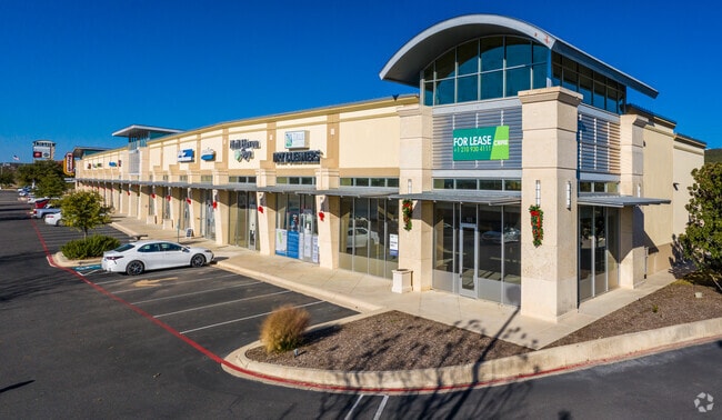
Property Record
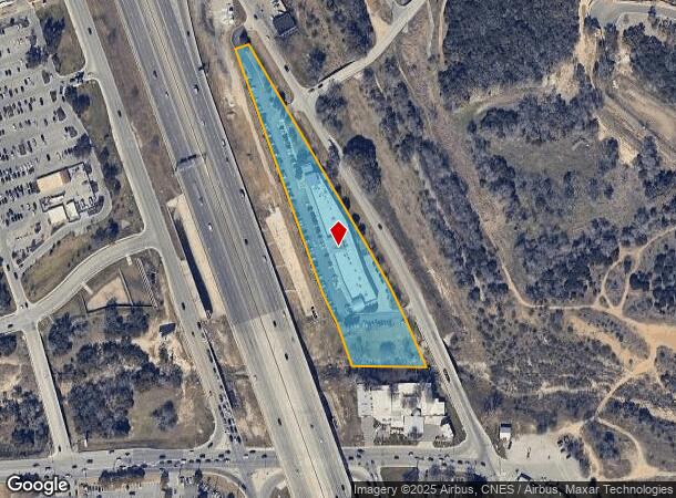
24200 W Interstate 10, San Antonio, TX 78257
NEARBY LISTINGS FOR SALE OR LEASE
Property Detail
24200 W Interstate 10
San Antonio-New Braunfels, TX
Leon Springs Subd
16392-001-0010
NCB 16392 BLK 1 LOT 1 (LEON SPRINGS SUBD) PLAT 9565/156
Regionalshoppingcenterormallwithanchorstore
Bexar
AE
Texas
48259C0525F
1
2024
3.45 AC
2025
Far Northwest
191807
San Antonio
29,227 SF
DEMOGRAPHICS near 24200 W Interstate 10
1 Mile
3 Mile
5 Mile
2024 Total Population
6,282
30,593
60,731
2029 Population
6,699
32,905
65,657
Pop Growth 2024-2029
+ 6.64%
+ 7.56%
+ 8.11%
Average Age
39
38
38
2024 Total Households
2,245
10,933
23,174
HH Growth 2024-2029
+ 6.95%
+ 7.77%
+ 8.35%
Median Household Inc
$101,887
$124,228
$111,368
Avg Household Size
2.70
2.80
2.60
2024 Avg HH Vehicles
2.00
2.00
2.00
Median Home Value
$404,812
$430,004
$437,285
Median Year Built
2007
2010
2010
Nearby Places
Map Layers
Map Styles
 Street
 Aerial
- Restaurants
- Banks
- Shops
- Fitness
- Groceries
PUBLIC TRANSPORTATION
AIRPORT
San Antonio International
DRIVE
WALK
Distance
San Antonio International
24 min
18.1 mi
Freight Ports
Calhoun Port
DRIVE
WALK
Distance
Calhoun Port
203 min
169.8 mi
Nearby Properties
Address
Land Use
TOTAL SIZE
Lot Size
Zoning
Address
Land Use
TOTAL SIZE
Lot Size
Zoning
Address
Land Use
TOTAL SIZE
Lot Size
Zoning
375,702 SF
10 AC
Address
Land Use
TOTAL SIZE
Lot Size
Zoning
361,559 SF
20 AC
Address
Land Use
TOTAL SIZE
Lot Size
Zoning
329,035 SF
21.28 AC
Address
Land Use
TOTAL SIZE
Lot Size
Zoning
312,150 SF
22.60 AC
Address
Land Use
TOTAL SIZE
Lot Size
Zoning
260,536 SF
10.71 AC
Address
Land Use
TOTAL SIZE
Lot Size
Zoning
272,094 SF
16.90 AC
Address
Land Use
TOTAL SIZE
Lot Size
Zoning
270,295 SF
14.07 AC
Address
Land Use
TOTAL SIZE
Lot Size
Zoning
269,056 SF
12.13 AC
Address
Land Use
TOTAL SIZE
Lot Size
Zoning
243,485 SF
9.34 AC
Address
Land Use
TOTAL SIZE
Lot Size
Zoning
138,046 SF
14.23 AC
Address
Land Use
TOTAL SIZE
Lot Size
Zoning
317,851 SF
16.37 AC
Address
Land Use
TOTAL SIZE
Lot Size
Zoning
82,873 SF
8.87 AC
Address
Land Use
TOTAL SIZE
Lot Size
Zoning
61,206 SF
3.71 AC
Address
Land Use
TOTAL SIZE
Lot Size
Zoning
115,343 SF
55.13 AC
Address
Land Use
TOTAL SIZE
Lot Size
Zoning
49,164 SF
11.98 AC
Address
Land Use
TOTAL SIZE
Lot Size
Zoning
56,058 SF
8.04 AC
Address
Land Use
TOTAL SIZE
Lot Size
Zoning
68,180 SF
10.22 AC
Address
Land Use
TOTAL SIZE
Lot Size
Zoning
141,203 SF
12.49 AC
Address
Land Use
TOTAL SIZE
Lot Size
Zoning
147,976 SF
16.48 AC
Address
Land Use
TOTAL SIZE
Lot Size
Zoning
45,441 SF
3.84 AC
Address
Land Use
TOTAL SIZE
Lot Size
Zoning
24,764 SF
4.50 AC
Address
Land Use
TOTAL SIZE
Lot Size
Zoning
142,425 SF
3.08 AC
Address
Land Use
TOTAL SIZE
Lot Size
Zoning
39,291 SF
4 AC
Address
Land Use
TOTAL SIZE
Lot Size
Zoning
129,911 SF
12.25 AC
Address
Land Use
TOTAL SIZE
Lot Size
Zoning
32,952 SF
2.39 AC
Address
Land Use
TOTAL SIZE
Lot Size
Zoning
35,926 SF
3.71 AC
Address
Land Use
TOTAL SIZE
Lot Size
Zoning
27,696 SF
2.97 AC
Address
Land Use
TOTAL SIZE
Lot Size
Zoning
102,935 SF
4.19 AC
Address
Land Use
TOTAL SIZE
Lot Size
Zoning
28,398 SF
5.04 AC
The World's #1 Commercial Real Estate Marketplace
Connect with us
© 2025 CoStar Group
The information above has been obtained from sources believed reliable. While we do not doubt its accuracy we have not verified it and make no guarantee, warranty or representation about it. It is your responsibility to independently confirm its accuracy and completeness. Any projections, opinions, assumptions, or estimates used are for example only and do not represent the current or future performance of the property. The value of this transaction to you depends on tax and other factors which should be evaluated by your tax, financial, and legal advisors. You and your advisors should conduct a careful, independent investigation of the property to determine to your satisfaction the suitability of the property for your needs.