Property Record
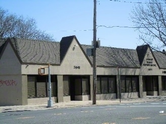
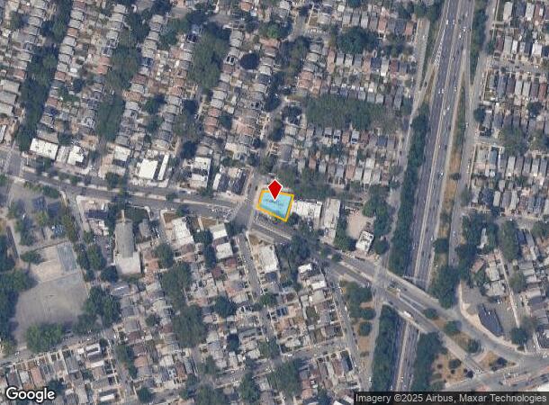
24201 Braddock Ave, Bellerose, NY 11426
NEARBY LISTINGS FOR SALE OR LEASE
Property Detail
24201 Braddock Ave
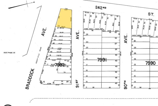
07992-0028
Queens
Officebuilding
New York
X
28
36059C0205G
0.16 AC
0
South Queens
2025
Long Island (New York)
162100
New York-Jersey City-White Plains, NY-NJ
13,000 SF
DEMOGRAPHICS near 24201 Braddock Ave
1 Mile
3 Mile
5 Mile
2024 Total Population
41,498
336,237
971,535
2029 Population
38,736
316,008
917,782
Pop Growth 2024-2029
(6.66%)
(6.02%)
(5.53%)
Average Age
43
43
42
2024 Total Households
12,622
108,925
320,844
HH Growth 2024-2029
(7.11%)
(6.39%)
(5.73%)
Median Household Inc
$99,105
$99,844
$91,937
Avg Household Size
3.10
3.00
2.90
2024 Avg HH Vehicles
2.00
2.00
1.00
Median Home Value
$701,257
$672,034
$689,993
Median Year Built
1947
1950
1952
Nearby Places
Map Layers
Map Styles
 Street
 Aerial
- Restaurants
- Banks
- Shops
- Fitness
- Groceries
PUBLIC TRANSPORTATION
TRANSIT/SUBWAY
Bellerose Station (Hempstead Branch - Long Island Rail Road)
DRIVE
WALK
Distance
Bellerose Station (Hempstead Branch - Long Island Rail Road)
5 min
15 min
0.8 mi
Queens Village Station (Hempstead Branch - Long Island Rail Road)
DRIVE
WALK
Distance
Queens Village Station (Hempstead Branch - Long Island Rail Road)
3 min
20 min
1.0 mi
COMMUTER RAIL
Bellerose Station (Hempstead Branch - Long Island Rail Road)
DRIVE
WALK
Distance
Bellerose Station (Hempstead Branch - Long Island Rail Road)
5 min
15 min
0.8 mi
Queens Village Station (Hempstead Branch - Long Island Rail Road)
DRIVE
WALK
Distance
Queens Village Station (Hempstead Branch - Long Island Rail Road)
3 min
18 min
0.9 mi
AIRPORT
John F Kennedy International
DRIVE
WALK
Distance
John F Kennedy International
16 min
9.2 mi
LaGuardia
DRIVE
WALK
Distance
LaGuardia
18 min
10.7 mi
Newark Liberty International
DRIVE
WALK
Distance
Newark Liberty International
45 min
36.6 mi
Freight Ports
NY - Red Hook Container Terminal
DRIVE
WALK
Distance
NY - Red Hook Container Terminal
30 min
18.8 mi
Nearby Properties
Address
Land Use
TOTAL SIZE
Lot Size
Zoning
Address
Land Use
TOTAL SIZE
Lot Size
Zoning
7,975 SF
133 AC
PARK
Address
Land Use
TOTAL SIZE
Lot Size
Zoning
1,667,567 SF
30 AC
R3-2
Address
Land Use
TOTAL SIZE
Lot Size
Zoning
986,724 SF
89.79 AC
R3-2
Address
Land Use
TOTAL SIZE
Lot Size
Zoning
878,386 SF
20.55 AC
R4
Address
Land Use
TOTAL SIZE
Lot Size
Zoning
800 SF
104.61 AC
PARK
Address
Land Use
TOTAL SIZE
Lot Size
Zoning
13,500 SF
104 AC
PARK
Address
Land Use
TOTAL SIZE
Lot Size
Zoning
947 SF
101.82 AC
PARK
Address
Land Use
TOTAL SIZE
Lot Size
Zoning
202,459 SF
82.16 AC
R3-2
Address
Land Use
TOTAL SIZE
Lot Size
Zoning
448,500 SF
22.59 AC
R3-2
Address
Land Use
TOTAL SIZE
Lot Size
Zoning
636,219 SF
11.39 AC
R3-2
Address
Land Use
TOTAL SIZE
Lot Size
Zoning
82.92 AC
PARK
Address
Land Use
TOTAL SIZE
Lot Size
Zoning
900 SF
86.35 AC
PARK
Address
Land Use
TOTAL SIZE
Lot Size
Zoning
511,684 SF
13.09 AC
R4
Address
Land Use
TOTAL SIZE
Lot Size
Zoning
1,800 SF
54.60 AC
PARK
Address
Land Use
TOTAL SIZE
Lot Size
Zoning
201,770 SF
7.09 AC
R3-2
Address
Land Use
TOTAL SIZE
Lot Size
Zoning
268,500 SF
27.50 AC
R4
Address
Land Use
TOTAL SIZE
Lot Size
Zoning
32,000 SF
50 AC
PARK
Address
Land Use
TOTAL SIZE
Lot Size
Zoning
1,400 SF
42.67 AC
PARK
Address
Land Use
TOTAL SIZE
Lot Size
Zoning
344,292 SF
12.56 AC
R4
Address
Land Use
TOTAL SIZE
Lot Size
Zoning
7,030 SF
12.43 AC
R3-2
Address
Land Use
TOTAL SIZE
Lot Size
Zoning
319,231 SF
3.76 AC
R4
Address
Land Use
TOTAL SIZE
Lot Size
Zoning
483,292 SF
23 AC
R4
Address
Land Use
TOTAL SIZE
Lot Size
Zoning
95.36 AC
PARK
Address
Land Use
TOTAL SIZE
Lot Size
Zoning
261,060 SF
3.31 AC
R3-2
Address
Land Use
TOTAL SIZE
Lot Size
Zoning
111,122 SF
8.94 AC
R3-2
Address
Land Use
TOTAL SIZE
Lot Size
Zoning
129,378 SF
4.86 AC
R2A
Address
Land Use
TOTAL SIZE
Lot Size
Zoning
187,000 SF
3.24 AC
R4-1
Address
Land Use
TOTAL SIZE
Lot Size
Zoning
123,832 SF
5.29 AC
R3-2
Address
Land Use
TOTAL SIZE
Lot Size
Zoning
231,865 SF
9.99 AC
C4-1
Address
Land Use
TOTAL SIZE
Lot Size
Zoning
86,700 SF
5.39 AC
R4
The World's #1 Commercial Real Estate Marketplace
Connect with us
© 2026 CoStar Group
The information above has been obtained from sources believed reliable. While we do not doubt its accuracy we have not verified it and make no guarantee, warranty or representation about it. It is your responsibility to independently confirm its accuracy and completeness. Any projections, opinions, assumptions, or estimates used are for example only and do not represent the current or future performance of the property. The value of this transaction to you depends on tax and other factors which should be evaluated by your tax, financial, and legal advisors. You and your advisors should conduct a careful, independent investigation of the property to determine to your satisfaction the suitability of the property for your needs.