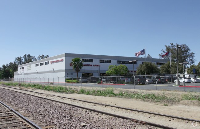
Property Record
24201 Orange Ave, Perris, CA 92570

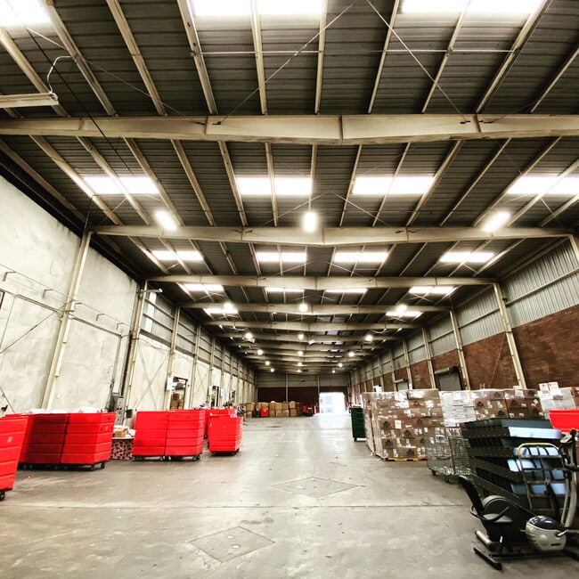
Property Detail
24201 Orange Ave
Riverside-San Bernardino-Ontario, CA
10.85 ACRES M/L IN POR PARS 2 & 3 AND PAR 4 RS 054/083
305-100-052
Riverside
Commercialnec
California
MH
2,3,4
B and X Area of moderate flood hazard, usually the area between the limits of the 100-year and 500-year floods.
10.85 AC
2024
Moreno Valley/Perris
2025
Inland Empire (California)
042905
NEARBY LISTINGS FOR SALE OR LEASE
DEMOGRAPHICS near 24201 Orange Ave
1 mile
3 mile
5 mile
2025 Total Population
2,184
71,926
119,309
2030 Population
2,261
73,836
122,302
Pop Growth 2025-2030
+ 3.53%
+ 2.66%
+ 2.51%
Average Age
35
33
34
2025 Total Households
524
17,025
28,228
HH Growth 2025-2030
+ 3.44%
+ 2.46%
+ 2.32%
Median Household Inc
$73,253
$80,989
$86,252
Avg Household Size
4.10
4.00
4.00
2025 Avg HH Vehicles
3.00
2.00
3.00
Median Home Value
$429,861
$450,696
$472,350
Median Year Built
1987
1994
1993
Nearby Places
Map Layers
Map Styles
 Street
 Aerial
Layers
 Traffic
 Biking
Places
Listings with unknown addresses are not visible on the map
- Restaurants
- Banks
- Shops
- Fitness
- Groceries
PUBLIC TRANSPORTATION
COMMUTER RAIL
Drive
Walk
Distance
6 min
2.7 mi
Drive
Walk
Distance
9 min
4.9 mi
AIRPORT
Ontario International
Drive
Walk
Distance
Ontario International
40 min
30.9 mi
SALE & LEASE HISTORY
LISTING DATE
SALE/LEASE

Feb 24, 2020
For Lease
Nearby Properties
Address
Land Use
TOTAL SIZE
Lot Size
Zoning
Address
Land Use
TOTAL SIZE
Lot Size
Zoning
1,189,664 SF
55.26 AC
Address
Land Use
TOTAL SIZE
Lot Size
Zoning
1,224,874 SF
59.05 AC
Address
Land Use
TOTAL SIZE
Lot Size
Zoning
1,009,869 SF
46.76 AC
Address
Land Use
TOTAL SIZE
Lot Size
Zoning
783,407 SF
36.72 AC
Address
Land Use
TOTAL SIZE
Lot Size
Zoning
656,695 SF
30.75 AC
RA5
Address
Land Use
TOTAL SIZE
Lot Size
Zoning
1,138,800 SF
43.93 AC
Address
Land Use
TOTAL SIZE
Lot Size
Zoning
1,309,754 SF
57.79 AC
IL
Address
Land Use
TOTAL SIZE
Lot Size
Zoning
579,708 SF
17.70 AC
LI
Address
Land Use
TOTAL SIZE
Lot Size
Zoning
343 SF
83.52 AC
LI
Address
Land Use
TOTAL SIZE
Lot Size
Zoning
678,087 SF
30.24 AC
Address
Land Use
TOTAL SIZE
Lot Size
Zoning
1,547,145 SF
83.15 AC
Address
Land Use
TOTAL SIZE
Lot Size
Zoning
1,364,580 SF
80.02 AC
Address
Land Use
TOTAL SIZE
Lot Size
Zoning
325,560 SF
16.65 AC
Address
Land Use
TOTAL SIZE
Lot Size
Zoning
1,172,289 SF
41.82 AC
Address
Land Use
TOTAL SIZE
Lot Size
Zoning
1,582,985 SF
83.28 AC
LI
Address
Land Use
TOTAL SIZE
Lot Size
Zoning
285,482 SF
9.65 AC
Address
Land Use
TOTAL SIZE
Lot Size
Zoning
800,218 SF
37.43 AC
Address
Land Use
TOTAL SIZE
Lot Size
Zoning
355,031 SF
16.29 AC
LI
Address
Land Use
TOTAL SIZE
Lot Size
Zoning
406,650 SF
21.49 AC
Address
Land Use
TOTAL SIZE
Lot Size
Zoning
864,000 SF
43.64 AC
RA10
Address
Land Use
TOTAL SIZE
Lot Size
Zoning
426,546 SF
14.78 AC
LI
Address
Land Use
TOTAL SIZE
Lot Size
Zoning
428,730 SF
16.85 AC
Address
Land Use
TOTAL SIZE
Lot Size
Zoning
1,224,406 SF
74.17 AC
Address
Land Use
TOTAL SIZE
Lot Size
Zoning
302,333 SF
15.60 AC
LI
Address
Land Use
TOTAL SIZE
Lot Size
Zoning
423,665 SF
20.83 AC
Address
Land Use
TOTAL SIZE
Lot Size
Zoning
600,000 SF
26.69 AC
MSC
Address
Land Use
TOTAL SIZE
Lot Size
Zoning
202,538 SF
9.58 AC
Address
Land Use
TOTAL SIZE
Lot Size
Zoning
429,823 SF
20.07 AC
The World's #1 Commercial Real Estate Marketplace
Connect with us
© 2026 CoStar Group
The information above has been obtained from sources believed reliable. While we do not doubt its accuracy we have not verified it and make no guarantee, warranty or representation about it. It is your responsibility to independently confirm its accuracy and completeness. Any projections, opinions, assumptions, or estimates used are for example only and do not represent the current or future performance of the property. The value of this transaction to you depends on tax and other factors which should be evaluated by your tax, financial, and legal advisors. You and your advisors should conduct a careful, independent investigation of the property to determine to your satisfaction the suitability of the property for your needs.