Property Record
2421 Malcom Bridge Rd, Bogart, GA 30622
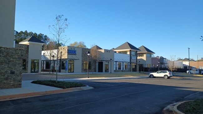
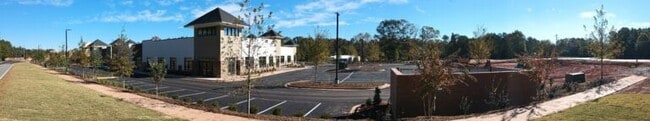
Property Detail
2421 Malcom Bridge Rd
Athens-Clarke County, GA
2024/55
B-02T-320
OCONEE
Stripcommercialcenter
Georgia
B-1
200
2025
0.07 AC
2025
Athens/Gainesville
030104
Other Market Areas
1,400 SF
NEARBY LISTINGS FOR SALE OR LEASE
-
-
View all Bogart listings for lease on LoopNet.com
DEMOGRAPHICS near 2421 Malcom Bridge Rd
1 mile
3 mile
5 mile
2025 Total Population
2,242
17,455
40,777
2030 Population
2,355
18,315
42,196
Pop Growth 2025-2030
+ 5.04%
+ 4.93%
+ 3.48%
Average Age
38
39
40
2025 Total Households
732
6,412
15,509
HH Growth 2025-2030
+ 5.19%
+ 4.76%
+ 3.17%
Median Household Inc
$167,724
$103,177
$93,826
Avg Household Size
3.00
2.70
2.60
2025 Avg HH Vehicles
2.00
2.00
2.00
Median Home Value
$617,424
$445,260
$423,374
Median Year Built
2006
2000
1997
Nearby Places
Map Layers
Map Styles
 Street
 Aerial
Layers
 Traffic
 Biking
Places
Listings with unknown addresses are not visible on the map
- Restaurants
- Banks
- Shops
- Fitness
- Groceries
SALE & LEASE HISTORY
LISTING DATE
SALE/LEASE

Jun 24, 2019
For Lease
Nearby Properties
Address
Land Use
TOTAL SIZE
Lot Size
Zoning
Address
Land Use
TOTAL SIZE
Lot Size
Zoning
20,504 SF
149.17 AC
AG
Address
Land Use
TOTAL SIZE
Lot Size
Zoning
212,919 SF
37.92 AC
RM-1
Address
Land Use
TOTAL SIZE
Lot Size
Zoning
317,646 SF
55.19 AC
AG
Address
Land Use
TOTAL SIZE
Lot Size
Zoning
17,388 SF
21.49 AC
RM-1
Address
Land Use
TOTAL SIZE
Lot Size
Zoning
93,677 SF
74.41 AC
AG
Address
Land Use
TOTAL SIZE
Lot Size
Zoning
108,668 SF
37.79 AC
001
Address
Land Use
TOTAL SIZE
Lot Size
Zoning
98,402 SF
8.11 AC
B-2
Address
Land Use
TOTAL SIZE
Lot Size
Zoning
1,020 SF
27.72 AC
RM-1
Address
Land Use
TOTAL SIZE
Lot Size
Zoning
154,270 SF
23.19 AC
Address
Land Use
TOTAL SIZE
Lot Size
Zoning
Address
Land Use
TOTAL SIZE
Lot Size
Zoning
1,462 SF
51.85 AC
R-3
Address
Land Use
TOTAL SIZE
Lot Size
Zoning
70,000 SF
5.40 AC
O-B-P
Address
Land Use
TOTAL SIZE
Lot Size
Zoning
68,931 SF
5.54 AC
O-B-P
Address
Land Use
TOTAL SIZE
Lot Size
Zoning
1 SF
126.93 AC
E-I
Address
Land Use
TOTAL SIZE
Lot Size
Zoning
71,928 SF
10.59 AC
C-G
Address
Land Use
TOTAL SIZE
Lot Size
Zoning
58,725 SF
3.14 AC
B-2
Address
Land Use
TOTAL SIZE
Lot Size
Zoning
20,213 SF
4.72 AC
B-1
Address
Land Use
TOTAL SIZE
Lot Size
Zoning
24,826 SF
4.25 AC
B-2
Address
Land Use
TOTAL SIZE
Lot Size
Zoning
29,874 SF
0.36 AC
O-I-P
Address
Land Use
TOTAL SIZE
Lot Size
Zoning
13,584 SF
23.95 AC
B-2
Address
Land Use
TOTAL SIZE
Lot Size
Zoning
425,000 SF
45.22 AC
I
Address
Land Use
TOTAL SIZE
Lot Size
Zoning
36,822 SF
2.57 AC
B-2
Address
Land Use
TOTAL SIZE
Lot Size
Zoning
37,572 SF
0.43 AC
O-B-P
Address
Land Use
TOTAL SIZE
Lot Size
Zoning
62,635 SF
6.27 AC
O-B-P
Address
Land Use
TOTAL SIZE
Lot Size
Zoning
137,764 SF
15.37 AC
C-G
Address
Land Use
TOTAL SIZE
Lot Size
Zoning
23,562 SF
30.09 AC
C-G
Address
Land Use
TOTAL SIZE
Lot Size
Zoning
20,714 SF
2.56 AC
Address
Land Use
TOTAL SIZE
Lot Size
Zoning
199.10 AC
RS-5
Address
Land Use
TOTAL SIZE
Lot Size
Zoning
23,265 SF
2.23 AC
B-2
Address
Land Use
TOTAL SIZE
Lot Size
Zoning
10,570 SF
10 AC
C-G
The World's #1 Commercial Real Estate Marketplace
Connect with us
© 2026 CoStar Group
The information above has been obtained from sources believed reliable. While we do not doubt its accuracy we have not verified it and make no guarantee, warranty or representation about it. It is your responsibility to independently confirm its accuracy and completeness. Any projections, opinions, assumptions, or estimates used are for example only and do not represent the current or future performance of the property. The value of this transaction to you depends on tax and other factors which should be evaluated by your tax, financial, and legal advisors. You and your advisors should conduct a careful, independent investigation of the property to determine to your satisfaction the suitability of the property for your needs.