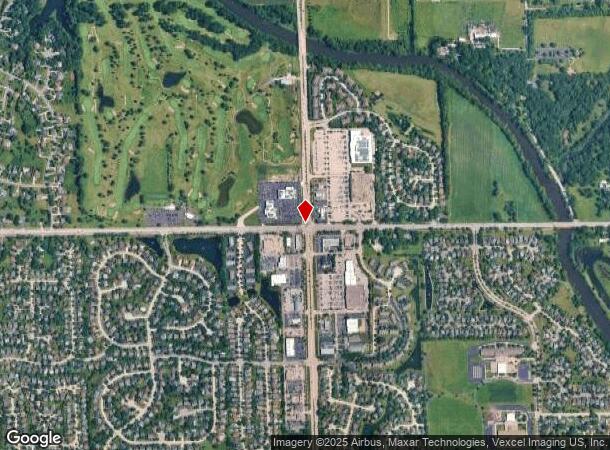
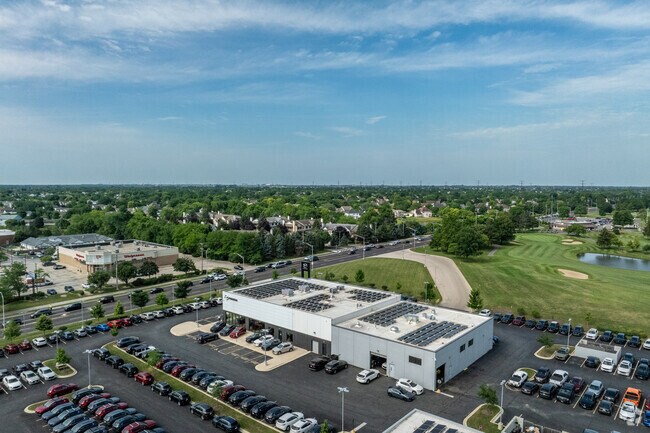
Property Record
2421 S Route 59 Rd, Plainfield, IL 60586

NEARBY LISTINGS FOR SALE OR LEASE
Property Detail
2421 S Route 59 Rd
Chicago
Hawk Motor Park
Chicago-Naperville-Elgin, IL-IN-WI
LOT 1 IN HAWK MOTOR PARK UNIT 1, BEING A SUB OF PRT OF THE SE1/4 OF SEC. 28, T36N-R9E.
06-03-28-401-001
Will
Commercialnec
Illinois
2023
1
2024
7.56 AC
880429
Joliet/Central Will
DEMOGRAPHICS near 2421 S Route 59 Rd
1 Mile
3 Mile
5 Mile
2024 Total Population
8,126
73,033
173,379
2029 Population
8,038
72,755
174,581
Pop Growth 2024-2029
(1.08%)
(0.38%)
+ 0.69%
Average Age
37
38
39
2024 Total Households
2,649
23,770
59,498
HH Growth 2024-2029
(1.09%)
(0.40%)
+ 0.55%
Median Household Inc
$116,553
$107,593
$94,805
Avg Household Size
3.00
3.00
2.80
2024 Avg HH Vehicles
2.00
2.00
2.00
Median Home Value
$258,777
$256,887
$254,017
Median Year Built
1994
1997
1997
Nearby Places
Map Layers
Map Styles
 Street
 Aerial
- Restaurants
- Banks
- Shops
- Fitness
- Groceries
PUBLIC TRANSPORTATION
COMMUTER RAIL
Joliet Station (Heritage Corridor Line - Northeast Illinois Regional Commuter Railroad (Metra), Rock Island District Line - Northeast Illinois Regional Commuter Railroad (Metra))
DRIVE
WALK
Distance
Joliet Station (Heritage Corridor Line - Northeast Illinois Regional Commuter Railroad (Metra), Rock Island District Line - Northeast Illinois Regional Commuter Railroad (Metra))
18 min
7.7 mi
Lockport Station (Heritage Corridor Line - Northeast Illinois Regional Commuter Railroad (Metra))
DRIVE
WALK
Distance
Lockport Station (Heritage Corridor Line - Northeast Illinois Regional Commuter Railroad (Metra))
21 min
9.2 mi
AIRPORT
Chicago Midway International
DRIVE
WALK
Distance
Chicago Midway International
44 min
30.8 mi
Freight Ports
Port Milwaukee
DRIVE
WALK
Distance
Port Milwaukee
142 min
113.9 mi
Nearby Properties
Address
Land Use
TOTAL SIZE
Lot Size
Zoning
Address
Land Use
TOTAL SIZE
Lot Size
Zoning
32.49 AC
Address
Land Use
TOTAL SIZE
Lot Size
Zoning
54.90 AC
Address
Land Use
TOTAL SIZE
Lot Size
Zoning
10.47 AC
Address
Land Use
TOTAL SIZE
Lot Size
Zoning
16.91 AC
Address
Land Use
TOTAL SIZE
Lot Size
Zoning
5.12 AC
Address
Land Use
TOTAL SIZE
Lot Size
Zoning
Address
Land Use
TOTAL SIZE
Lot Size
Zoning
1.66 AC
Address
Land Use
TOTAL SIZE
Lot Size
Zoning
84,899 SF
3.98 AC
Address
Land Use
TOTAL SIZE
Lot Size
Zoning
8.46 AC
Address
Land Use
TOTAL SIZE
Lot Size
Zoning
64,046 SF
5.41 AC
Address
Land Use
TOTAL SIZE
Lot Size
Zoning
123,698 SF
10.88 AC
Address
Land Use
TOTAL SIZE
Lot Size
Zoning
105,825 SF
2.62 AC
Address
Land Use
TOTAL SIZE
Lot Size
Zoning
65,977 SF
5.07 AC
Address
Land Use
TOTAL SIZE
Lot Size
Zoning
52,132 SF
6.48 AC
Address
Land Use
TOTAL SIZE
Lot Size
Zoning
68,154 SF
6.94 AC
Address
Land Use
TOTAL SIZE
Lot Size
Zoning
8.91 AC
Address
Land Use
TOTAL SIZE
Lot Size
Zoning
8.99 AC
Address
Land Use
TOTAL SIZE
Lot Size
Zoning
64,624 SF
12.04 AC
Address
Land Use
TOTAL SIZE
Lot Size
Zoning
6.58 AC
Address
Land Use
TOTAL SIZE
Lot Size
Zoning
0.82 AC
Address
Land Use
TOTAL SIZE
Lot Size
Zoning
12.94 AC
Address
Land Use
TOTAL SIZE
Lot Size
Zoning
2.64 AC
Address
Land Use
TOTAL SIZE
Lot Size
Zoning
16.46 AC
Address
Land Use
TOTAL SIZE
Lot Size
Zoning
8.85 AC
Address
Land Use
TOTAL SIZE
Lot Size
Zoning
8.55 AC
Address
Land Use
TOTAL SIZE
Lot Size
Zoning
106,715 SF
10.96 AC
Address
Land Use
TOTAL SIZE
Lot Size
Zoning
Address
Land Use
TOTAL SIZE
Lot Size
Zoning
70,600 SF
5 AC
Address
Land Use
TOTAL SIZE
Lot Size
Zoning
8.06 AC
The World's #1 Commercial Real Estate Marketplace
Connect with us
© 2026 CoStar Group
The information above has been obtained from sources believed reliable. While we do not doubt its accuracy we have not verified it and make no guarantee, warranty or representation about it. It is your responsibility to independently confirm its accuracy and completeness. Any projections, opinions, assumptions, or estimates used are for example only and do not represent the current or future performance of the property. The value of this transaction to you depends on tax and other factors which should be evaluated by your tax, financial, and legal advisors. You and your advisors should conduct a careful, independent investigation of the property to determine to your satisfaction the suitability of the property for your needs.