Property Record
2424 N Wyatt Dr, Tucson, AZ 85712


Current Lease Availabilities
NEARBY LISTINGS FOR SALE OR LEASE
Property Detail
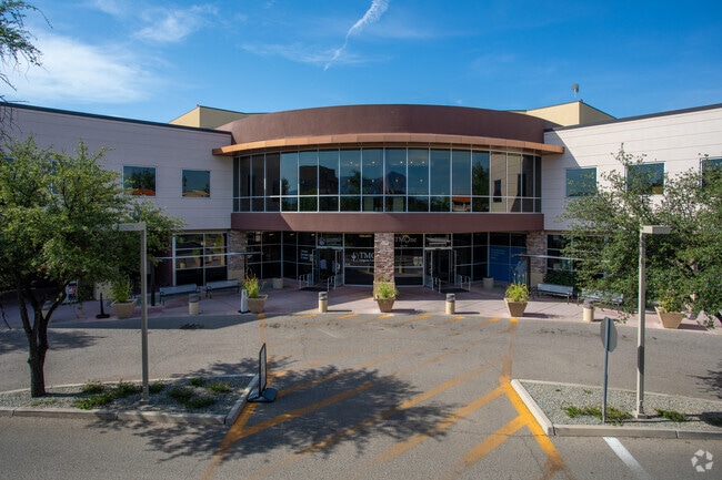
2424 N Wyatt Dr
Tucson, AZ
Tucson Medical Center
110-12-0950
TUCSON MEDICAL CENTER LOT 6
Medicalbuilding
Pima
X
Arizona
04019C1694L
6
2025
4.19 AC
2025
Central Tucson
002904
Tucson
252,150 SF
DEMOGRAPHICS near 2424 N Wyatt Dr
1 Mile
3 Mile
5 Mile
2024 Total Population
12,803
101,166
269,058
2029 Population
13,323
104,857
278,856
Pop Growth 2024-2029
+ 4.06%
+ 3.65%
+ 3.64%
Average Age
45
42
40
2024 Total Households
5,963
49,679
125,133
HH Growth 2024-2029
+ 4.02%
+ 3.66%
+ 3.71%
Median Household Inc
$47,474
$47,437
$49,231
Avg Household Size
1.90
1.90
2.00
2024 Avg HH Vehicles
1.00
1.00
2.00
Median Home Value
$249,332
$269,809
$268,663
Median Year Built
1972
1972
1974
Nearby Places
Map Layers
Map Styles
 Street
 Aerial
- Restaurants
- Banks
- Shops
- Fitness
- Groceries
PUBLIC TRANSPORTATION
COMMUTER RAIL
Tucson Amtrak Station (Sunset Limited - Amtrak, Texas Eagle - Amtrak)
DRIVE
WALK
Distance
Tucson Amtrak Station (Sunset Limited - Amtrak, Texas Eagle - Amtrak)
16 min
7.2 mi
AIRPORT
Tucson International
DRIVE
WALK
Distance
Tucson International
22 min
12.3 mi
Freight Ports
Port of San Diego
DRIVE
WALK
Distance
Port of San Diego
443 min
412.5 mi
Nearby Properties
Address
Land Use
TOTAL SIZE
Lot Size
Zoning
Address
Land Use
TOTAL SIZE
Lot Size
Zoning
1,089,840 SF
45.56 AC
Address
Land Use
TOTAL SIZE
Lot Size
Zoning
53,431 SF
9.98 AC
Address
Land Use
TOTAL SIZE
Lot Size
Zoning
684,356 SF
19.65 AC
PAD13
Address
Land Use
TOTAL SIZE
Lot Size
Zoning
595,881 SF
62.57 AC
Address
Land Use
TOTAL SIZE
Lot Size
Zoning
473,573 SF
22.65 AC
C3
Address
Land Use
TOTAL SIZE
Lot Size
Zoning
295,133 SF
36.29 AC
R1
Address
Land Use
TOTAL SIZE
Lot Size
Zoning
419,317 SF
7.23 AC
Address
Land Use
TOTAL SIZE
Lot Size
Zoning
261,002 SF
37.28 AC
R1
Address
Land Use
TOTAL SIZE
Lot Size
Zoning
137,890 SF
8.28 AC
PAD1
Address
Land Use
TOTAL SIZE
Lot Size
Zoning
413,801 SF
8.10 AC
OCR2
Address
Land Use
TOTAL SIZE
Lot Size
Zoning
168,286 SF
7.36 AC
Address
Land Use
TOTAL SIZE
Lot Size
Zoning
430,180 SF
19.78 AC
R3
Address
Land Use
TOTAL SIZE
Lot Size
Zoning
406,400 SF
4.29 AC
PAD1
Address
Land Use
TOTAL SIZE
Lot Size
Zoning
11,074 SF
0.94 AC
C1
Address
Land Use
TOTAL SIZE
Lot Size
Zoning
224,883 SF
27.62 AC
Address
Land Use
TOTAL SIZE
Lot Size
Zoning
139,963 SF
19.86 AC
R2
Address
Land Use
TOTAL SIZE
Lot Size
Zoning
364,128 SF
11.55 AC
O3
Address
Land Use
TOTAL SIZE
Lot Size
Zoning
109,335 SF
7.83 AC
PAD13
Address
Land Use
TOTAL SIZE
Lot Size
Zoning
256,775 SF
6.69 AC
C1
Address
Land Use
TOTAL SIZE
Lot Size
Zoning
180,149 SF
17.48 AC
PAD3
Address
Land Use
TOTAL SIZE
Lot Size
Zoning
110,414 SF
2.59 AC
C1
Address
Land Use
TOTAL SIZE
Lot Size
Zoning
326,189 SF
4.31 AC
O3
Address
Land Use
TOTAL SIZE
Lot Size
Zoning
231,434 SF
11.99 AC
Address
Land Use
TOTAL SIZE
Lot Size
Zoning
20,802 SF
1.86 AC
MU
Address
Land Use
TOTAL SIZE
Lot Size
Zoning
162,473 SF
6.08 AC
C3
Address
Land Use
TOTAL SIZE
Lot Size
Zoning
240,585 SF
18.16 AC
R2
Address
Land Use
TOTAL SIZE
Lot Size
Zoning
74,815 SF
5.05 AC
Address
Land Use
TOTAL SIZE
Lot Size
Zoning
217,152 SF
5.37 AC
PAD1
Address
Land Use
TOTAL SIZE
Lot Size
Zoning
162,630 SF
15.14 AC
Address
Land Use
TOTAL SIZE
Lot Size
Zoning
286,164 SF
5.80 AC
C3
The World's #1 Commercial Real Estate Marketplace
Connect with us
© 2025 CoStar Group
The information above has been obtained from sources believed reliable. While we do not doubt its accuracy we have not verified it and make no guarantee, warranty or representation about it. It is your responsibility to independently confirm its accuracy and completeness. Any projections, opinions, assumptions, or estimates used are for example only and do not represent the current or future performance of the property. The value of this transaction to you depends on tax and other factors which should be evaluated by your tax, financial, and legal advisors. You and your advisors should conduct a careful, independent investigation of the property to determine to your satisfaction the suitability of the property for your needs.