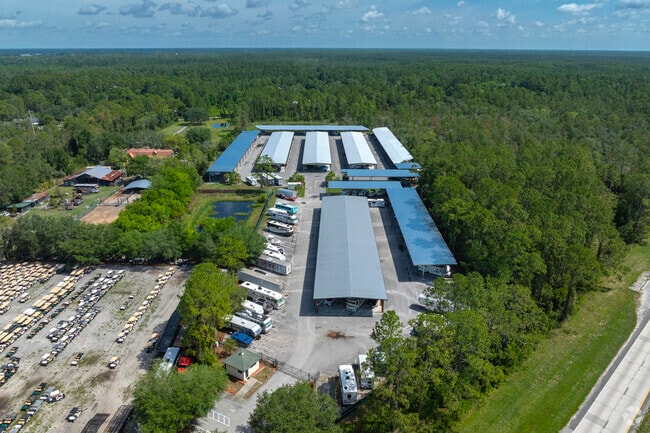
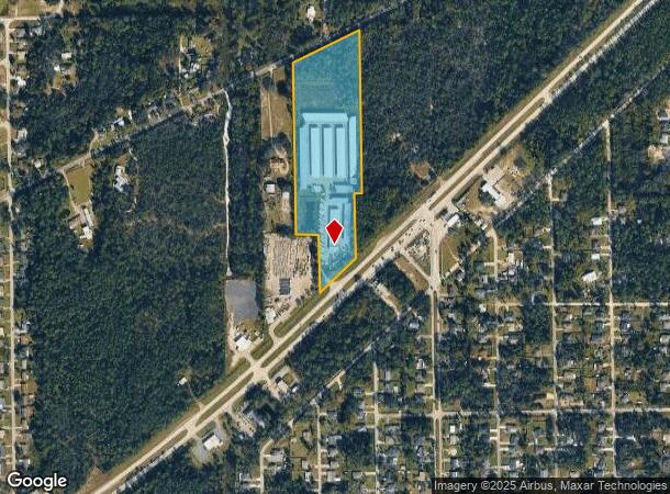
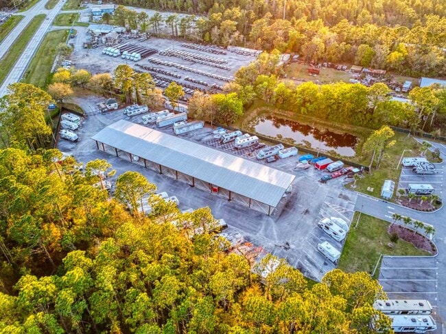
Property Record
2425 E International Speedway Blvd, Deland, FL 32724

Current Lease Availabilities
NEARBY LISTINGS FOR SALE OR LEASE
Property Detail
2425 E International Speedway Blvd
6036-00-00-0035
Parcel
Shipyard
36-16-30 IRREG PARCEL IN NW 1/4 AS DESCRIBED IN OR 7772 PG 4586 & OR 7772 PG 4592 & MEAS 463.5 FT ALONG SOUTH ROW LINE OF OLD DAYTONA ROAD & 1064.35 FT ON W/L & 312.02 FT ALONG NORTH ROW LINE OF US HWY 92 PER OR 8258 PG 4757
X
Volusia
12127C0460H
Florida
2025
12.28 AC
2026
NW Volusia County
090303
Deltona/Daytona Beach
122,966 SF
Deltona-Daytona Beach-Ormond Beach, FL
DEMOGRAPHICS near 2425 E International Speedway Blvd
1 Mile
3 Mile
5 Mile
2024 Total Population
2,891
11,649
47,755
2029 Population
3,218
12,894
52,775
Pop Growth 2024-2029
+ 11.31%
+ 10.69%
+ 10.51%
Average Age
41
42
42
2024 Total Households
1,099
4,609
18,537
HH Growth 2024-2029
+ 11.37%
+ 10.70%
+ 10.68%
Median Household Inc
$61,630
$59,070
$55,896
Avg Household Size
2.60
2.40
2.30
2024 Avg HH Vehicles
2.00
2.00
2.00
Median Home Value
$228,956
$186,038
$225,531
Median Year Built
1986
1986
1984
Nearby Places
Map Layers
Map Styles
 Street
 Aerial
- Restaurants
- Banks
- Shops
- Fitness
- Groceries
PUBLIC TRANSPORTATION
AIRPORT
Daytona Beach International
DRIVE
WALK
Distance
Daytona Beach International
19 min
14.7 mi
Orlando Sanford International
DRIVE
WALK
Distance
Orlando Sanford International
37 min
30.9 mi
Freight Ports
Port Canaveral
DRIVE
WALK
Distance
Port Canaveral
1 min
60.2 mi
Nearby Properties
Address
Land Use
TOTAL SIZE
Lot Size
Zoning
Address
Land Use
TOTAL SIZE
Lot Size
Zoning
493,551 SF
51.22 AC
05R4
Address
Land Use
TOTAL SIZE
Lot Size
Zoning
130,484 SF
14.35 AC
Address
Land Use
TOTAL SIZE
Lot Size
Zoning
101,732 SF
25.47 AC
P
Address
Land Use
TOTAL SIZE
Lot Size
Zoning
299,124 SF
14.94 AC
Address
Land Use
TOTAL SIZE
Lot Size
Zoning
221,179 SF
23.98 AC
Address
Land Use
TOTAL SIZE
Lot Size
Zoning
3,364 SF
23 AC
01A1
Address
Land Use
TOTAL SIZE
Lot Size
Zoning
406,163 SF
43.93 AC
I1
Address
Land Use
TOTAL SIZE
Lot Size
Zoning
388,366 SF
47.70 AC
Address
Land Use
TOTAL SIZE
Lot Size
Zoning
147,318 SF
18.23 AC
B4
Address
Land Use
TOTAL SIZE
Lot Size
Zoning
119,831 SF
8.38 AC
Address
Land Use
TOTAL SIZE
Lot Size
Zoning
81,242 SF
25.89 AC
05R4
Address
Land Use
TOTAL SIZE
Lot Size
Zoning
84,772 SF
20 AC
I1
Address
Land Use
TOTAL SIZE
Lot Size
Zoning
69,168 SF
479.27 AC
Address
Land Use
TOTAL SIZE
Lot Size
Zoning
81,941 SF
9.49 AC
B4
Address
Land Use
TOTAL SIZE
Lot Size
Zoning
62,309 SF
7.27 AC
05M1
Address
Land Use
TOTAL SIZE
Lot Size
Zoning
91,664 SF
9.09 AC
01I1
Address
Land Use
TOTAL SIZE
Lot Size
Zoning
120,884 SF
4.60 AC
05C2
Address
Land Use
TOTAL SIZE
Lot Size
Zoning
195,795 SF
30.20 AC
Address
Land Use
TOTAL SIZE
Lot Size
Zoning
141,857 SF
17.40 AC
01I1
Address
Land Use
TOTAL SIZE
Lot Size
Zoning
32,734 SF
1.55 AC
05C2
Address
Land Use
TOTAL SIZE
Lot Size
Zoning
44,400 SF
4.97 AC
01B4
Address
Land Use
TOTAL SIZE
Lot Size
Zoning
3,800.51 AC
RC
Address
Land Use
TOTAL SIZE
Lot Size
Zoning
107,082 SF
6.40 AC
Address
Land Use
TOTAL SIZE
Lot Size
Zoning
43,004 SF
4.81 AC
05R12
Address
Land Use
TOTAL SIZE
Lot Size
Zoning
54,928 SF
9.20 AC
01I1
Address
Land Use
TOTAL SIZE
Lot Size
Zoning
95,618 SF
4.10 AC
Address
Land Use
TOTAL SIZE
Lot Size
Zoning
48,583 SF
3.13 AC
05M1
Address
Land Use
TOTAL SIZE
Lot Size
Zoning
27,036 SF
4.87 AC
01B4
Address
Land Use
TOTAL SIZE
Lot Size
Zoning
38,688 SF
0.68 AC
05C1
The World's #1 Commercial Real Estate Marketplace
Connect with us
© 2026 CoStar Group
The information above has been obtained from sources believed reliable. While we do not doubt its accuracy we have not verified it and make no guarantee, warranty or representation about it. It is your responsibility to independently confirm its accuracy and completeness. Any projections, opinions, assumptions, or estimates used are for example only and do not represent the current or future performance of the property. The value of this transaction to you depends on tax and other factors which should be evaluated by your tax, financial, and legal advisors. You and your advisors should conduct a careful, independent investigation of the property to determine to your satisfaction the suitability of the property for your needs.