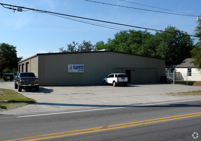
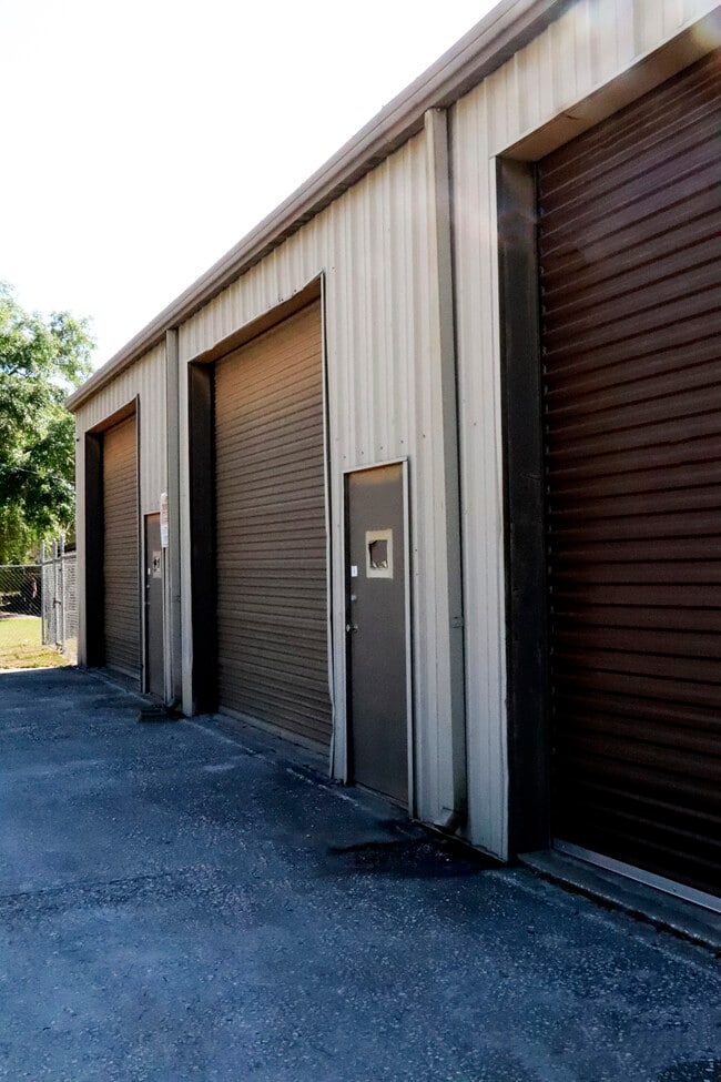
Property Record
2425 E Main St, Lakeland, FL 33801


Property Detail
2425 E Main St
24-28-16-000000-022040
BEG 25 FT S OF NW COR OF SE1/4 OF SE1/4 RUN E 120 FT S 150 FT W 120 FT N 150 FT TO BEG LESS MAINT R/W FOR MAIN ST PER MB 1 PG 207
Warehouse
Polk
R2
Florida
B and X Area of moderate flood hazard, usually the area between the limits of the 100-year and 500-year floods.
0.37 AC
2024
Polk County
2025
Tampa/St Petersburg
011731
Lakeland-Winter Haven, FL
6,000 SF
NEARBY LISTINGS FOR SALE OR LEASE
DEMOGRAPHICS near 2425 E Main St
1 mile
3 mile
5 mile
2025 Total Population
8,364
54,819
134,300
2030 Population
9,529
62,190
152,787
Pop Growth 2025-2030
+ 13.93%
+ 13.45%
+ 13.77%
Average Age
35
37
40
2025 Total Households
2,756
20,258
53,302
HH Growth 2025-2030
+ 14.26%
+ 14.20%
+ 14.25%
Median Household Inc
$55,668
$56,549
$59,361
Avg Household Size
2.50
2.30
2.30
2025 Avg HH Vehicles
2.00
2.00
2.00
Median Home Value
$167,030
$202,825
$211,345
Median Year Built
1977
1975
1980
Nearby Places
Map Layers
Map Styles
 Street
 Aerial
Transit
 Traffic
 Biking
Places
Listings with unknown addresses are not visible on the map
- Restaurants
- Banks
- Shops
- Fitness
- Groceries
PUBLIC TRANSPORTATION
COMMUTER RAIL
Lakeland (Silver Star - Amtrak)
Drive
Walk
Distance
Lakeland (Silver Star - Amtrak)
5 min
2.7 mi
Freight Ports
Port of Tampa Bay
Drive
Walk
Distance
Port of Tampa Bay
51 min
37.0 mi
SALE & LEASE HISTORY
LISTING DATE
SALE/LEASE

Mar 02, 2022
For Lease
Apr 01, 2021
For Sale
Nearby Properties
Address
Land Use
TOTAL SIZE
Lot Size
Zoning
Address
Land Use
TOTAL SIZE
Lot Size
Zoning
2,325,080 SF
27.05 AC
PUD
Address
Land Use
TOTAL SIZE
Lot Size
Zoning
414,112 SF
13.60 AC
MF22
Address
Land Use
TOTAL SIZE
Lot Size
Zoning
417,661 SF
39.48 AC
Address
Land Use
TOTAL SIZE
Lot Size
Zoning
718,026 SF
49.37 AC
RE2
Address
Land Use
TOTAL SIZE
Lot Size
Zoning
24,871 SF
54.24 AC
RB1
Address
Land Use
TOTAL SIZE
Lot Size
Zoning
295,706 SF
1.19 AC
Address
Land Use
TOTAL SIZE
Lot Size
Zoning
394,631 SF
32.27 AC
XX
Address
Land Use
TOTAL SIZE
Lot Size
Zoning
282,596 SF
27.51 AC
RA3
Address
Land Use
TOTAL SIZE
Lot Size
Zoning
132,716 SF
20.62 AC
Address
Land Use
TOTAL SIZE
Lot Size
Zoning
165,743 SF
17.11 AC
PUD
Address
Land Use
TOTAL SIZE
Lot Size
Zoning
155,735 SF
24.24 AC
XX
Address
Land Use
TOTAL SIZE
Lot Size
Zoning
103,446 SF
2.12 AC
RB1
Address
Land Use
TOTAL SIZE
Lot Size
Zoning
135,189 SF
2.57 AC
RB1
Address
Land Use
TOTAL SIZE
Lot Size
Zoning
96,412 SF
11.03 AC
I1
Address
Land Use
TOTAL SIZE
Lot Size
Zoning
286,120 SF
2.49 AC
C6
Address
Land Use
TOTAL SIZE
Lot Size
Zoning
175,230 SF
7.23 AC
MF22
Address
Land Use
TOTAL SIZE
Lot Size
Zoning
109,883 SF
12.40 AC
C4
Address
Land Use
TOTAL SIZE
Lot Size
Zoning
130,375 SF
14.51 AC
Address
Land Use
TOTAL SIZE
Lot Size
Zoning
218,911 SF
39.21 AC
Address
Land Use
TOTAL SIZE
Lot Size
Zoning
316,800 SF
9.47 AC
Address
Land Use
TOTAL SIZE
Lot Size
Zoning
206,796 SF
14.28 AC
I1
Address
Land Use
TOTAL SIZE
Lot Size
Zoning
152,129 SF
19.35 AC
MF12
Address
Land Use
TOTAL SIZE
Lot Size
Zoning
325,851 SF
21.97 AC
C4
Address
Land Use
TOTAL SIZE
Lot Size
Zoning
81,363 SF
9.98 AC
PUD
Address
Land Use
TOTAL SIZE
Lot Size
Zoning
154,016 SF
7.24 AC
PUD
Address
Land Use
TOTAL SIZE
Lot Size
Zoning
55,772 SF
0.87 AC
MF22
Address
Land Use
TOTAL SIZE
Lot Size
Zoning
259,200 SF
8.17 AC
Address
Land Use
TOTAL SIZE
Lot Size
Zoning
111,750 SF
1.33 AC
C6
Address
Land Use
TOTAL SIZE
Lot Size
Zoning
108,000 SF
2.14 AC
PUD
Address
Land Use
TOTAL SIZE
Lot Size
Zoning
82,416 SF
0.88 AC
The World's #1 Commercial Real Estate Marketplace
Connect with us
© 2026 CoStar Group
The information above has been obtained from sources believed reliable. While we do not doubt its accuracy we have not verified it and make no guarantee, warranty or representation about it. It is your responsibility to independently confirm its accuracy and completeness. Any projections, opinions, assumptions, or estimates used are for example only and do not represent the current or future performance of the property. The value of this transaction to you depends on tax and other factors which should be evaluated by your tax, financial, and legal advisors. You and your advisors should conduct a careful, independent investigation of the property to determine to your satisfaction the suitability of the property for your needs.