Property Record
2425 E State Route 69, Prescott, AZ 86301
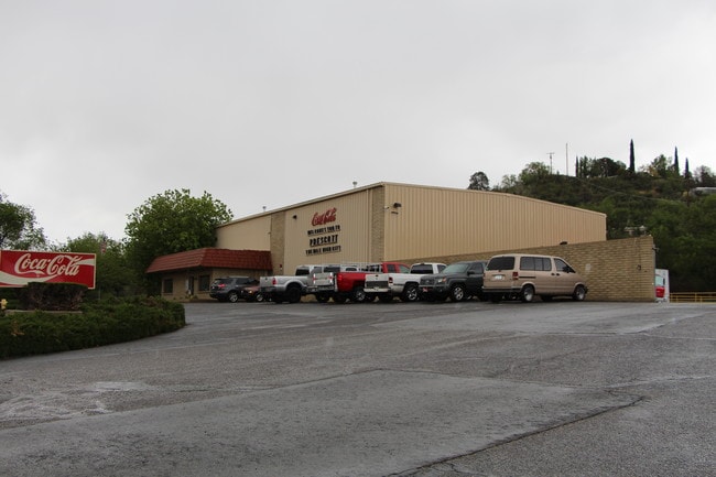

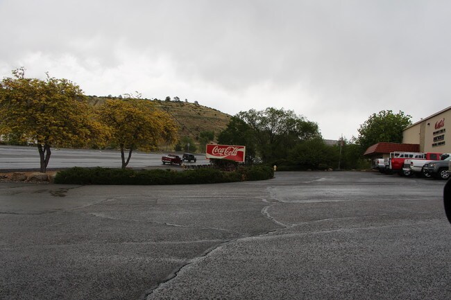
Property Detail
2425 E State Route 69
Prescott, AZ
AN IRREGULAR PARCEL BY M&B LYING IN THE SE4 NW4 OF S36-T14N-R02W. THE EASTMOST PAR. COR. IS APPROX. 1795 S & 12 W FROM THE N4 C OR. OF SAID SEC.
112-05-032
Yavapai
Warehouse
Arizona
B and X Area of moderate flood hazard, usually the area between the limits of the 100-year and 500-year floods.
10
2024
2.06 AC
2026
Prescott & Sedona
000802
Other Market Areas
10,000 SF
NEARBY LISTINGS FOR SALE OR LEASE
DEMOGRAPHICS near 2425 E State Route 69
1 mile
3 mile
5 mile
2025 Total Population
1,093
21,644
59,048
2030 Population
1,184
22,998
62,686
Pop Growth 2025-2030
+ 8.33%
+ 6.26%
+ 6.16%
Average Age
57
52
51
2025 Total Households
529
10,567
28,373
HH Growth 2025-2030
+ 8.32%
+ 6.28%
+ 6.27%
Median Household Inc
$54,142
$66,637
$70,057
Avg Household Size
2.00
2.00
2.00
2025 Avg HH Vehicles
2.00
2.00
2.00
Median Home Value
$564,356
$618,001
$555,647
Median Year Built
1996
1995
1993
Nearby Places
Map Layers
Map Styles
 Street
 Aerial
Transit
 Traffic
 Biking
Places
Listings with unknown addresses are not visible on the map
- Restaurants
- Banks
- Shops
- Fitness
- Groceries
SALE & LEASE HISTORY
LISTING DATE
SALE/LEASE

May 06, 2019
For Sale
Nearby Properties
Address
Land Use
TOTAL SIZE
Lot Size
Zoning
Address
Land Use
TOTAL SIZE
Lot Size
Zoning
322,026 SF
13.05 AC
Address
Land Use
TOTAL SIZE
Lot Size
Zoning
334,628 SF
15.03 AC
Address
Land Use
TOTAL SIZE
Lot Size
Zoning
127,271 SF
11.10 AC
Address
Land Use
TOTAL SIZE
Lot Size
Zoning
73,133 SF
75.73 AC
Address
Land Use
TOTAL SIZE
Lot Size
Zoning
103,382 SF
3.43 AC
Address
Land Use
TOTAL SIZE
Lot Size
Zoning
110,011 SF
8.04 AC
Address
Land Use
TOTAL SIZE
Lot Size
Zoning
17,200 SF
88.32 AC
Address
Land Use
TOTAL SIZE
Lot Size
Zoning
122,130 SF
2.20 AC
Address
Land Use
TOTAL SIZE
Lot Size
Zoning
67,239 SF
Address
Land Use
TOTAL SIZE
Lot Size
Zoning
206,246 SF
21.78 AC
Address
Land Use
TOTAL SIZE
Lot Size
Zoning
142,636 SF
1.14 AC
Address
Land Use
TOTAL SIZE
Lot Size
Zoning
30,000 SF
44.55 AC
Address
Land Use
TOTAL SIZE
Lot Size
Zoning
81,618 SF
2.77 AC
Address
Land Use
TOTAL SIZE
Lot Size
Zoning
47,587 SF
5.86 AC
Address
Land Use
TOTAL SIZE
Lot Size
Zoning
35,353 SF
1.12 AC
Address
Land Use
TOTAL SIZE
Lot Size
Zoning
58,352 SF
4.48 AC
Address
Land Use
TOTAL SIZE
Lot Size
Zoning
64,987 SF
2.62 AC
Address
Land Use
TOTAL SIZE
Lot Size
Zoning
48,488 SF
5.50 AC
Address
Land Use
TOTAL SIZE
Lot Size
Zoning
81,231 SF
5.44 AC
Address
Land Use
TOTAL SIZE
Lot Size
Zoning
137,787 SF
13.63 AC
Address
Land Use
TOTAL SIZE
Lot Size
Zoning
30,638 SF
1.25 AC
Address
Land Use
TOTAL SIZE
Lot Size
Zoning
49,570 SF
2.75 AC
Address
Land Use
TOTAL SIZE
Lot Size
Zoning
49,399 SF
7.48 AC
Address
Land Use
TOTAL SIZE
Lot Size
Zoning
149,185 SF
15.51 AC
Address
Land Use
TOTAL SIZE
Lot Size
Zoning
30,965 SF
118.55 AC
Address
Land Use
TOTAL SIZE
Lot Size
Zoning
102,188 SF
6.97 AC
Address
Land Use
TOTAL SIZE
Lot Size
Zoning
52,136 SF
0.75 AC
Address
Land Use
TOTAL SIZE
Lot Size
Zoning
43,896 SF
4.06 AC
Address
Land Use
TOTAL SIZE
Lot Size
Zoning
37,600 SF
7.96 AC
Address
Land Use
TOTAL SIZE
Lot Size
Zoning
49,477 SF
0.34 AC
The World's #1 Commercial Real Estate Marketplace
Connect with us
© 2026 CoStar Group
The information above has been obtained from sources believed reliable. While we do not doubt its accuracy we have not verified it and make no guarantee, warranty or representation about it. It is your responsibility to independently confirm its accuracy and completeness. Any projections, opinions, assumptions, or estimates used are for example only and do not represent the current or future performance of the property. The value of this transaction to you depends on tax and other factors which should be evaluated by your tax, financial, and legal advisors. You and your advisors should conduct a careful, independent investigation of the property to determine to your satisfaction the suitability of the property for your needs.