Property Record
2425 Gt Dr, Waterloo, IA 50703


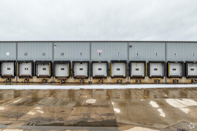
Property Detail
2425 Gt Dr
Waterloo-Cedar Falls, IA
NORTHEAST INDUSTRIAL PARK PLAT NO 3 LOT 13 & LOT 12 EXC THAT PART LOT 12 IN THE NORTHEAST INDUSTRIAL PARK PLAT 1 A PARCEL OF
8912-20-176-012
BLACK HAWK
Warehouse
Iowa
AE The base floodplain where base flood elevations are provided. AE Zones are now used on new format FIRMs instead of A1-A30 Zones.
6-7
2024
7.58 AC
2025
Iowa City/Waterloo
001900
Other Market Areas
69,120 SF
NEARBY LISTINGS FOR SALE OR LEASE
-
-
View all Waterloo listings for sale on LoopNet.com
DEMOGRAPHICS near 2425 Gt Dr
1 mile
3 mile
5 mile
2025 Total Population
1,363
22,700
61,372
2030 Population
1,408
23,324
62,401
Pop Growth 2025-2030
+ 3.30%
+ 2.75%
+ 1.68%
Average Age
40
39
39
2025 Total Households
560
9,479
26,157
HH Growth 2025-2030
+ 3.21%
+ 2.89%
+ 1.74%
Median Household Inc
$62,666
$45,784
$52,231
Avg Household Size
2.40
2.30
2.30
2025 Avg HH Vehicles
2.00
2.00
2.00
Median Home Value
$128,400
$108,178
$147,213
Median Year Built
1957
1954
1957
Nearby Places
Map Layers
Map Styles
 Street
 Aerial
Layers
 Traffic
 Biking
Places
Listings with unknown addresses are not visible on the map
- Restaurants
- Banks
- Shops
- Fitness
- Groceries
Nearby Properties
Address
Land Use
TOTAL SIZE
Lot Size
Zoning
Address
Land Use
TOTAL SIZE
Lot Size
Zoning
528,634 SF
13.33 AC
Address
Land Use
TOTAL SIZE
Lot Size
Zoning
108,671 SF
3.72 AC
Address
Land Use
TOTAL SIZE
Lot Size
Zoning
9,537 SF
104.11 AC
Address
Land Use
TOTAL SIZE
Lot Size
Zoning
153,600 SF
50 AC
Address
Land Use
TOTAL SIZE
Lot Size
Zoning
608,640 SF
134.12 AC
Address
Land Use
TOTAL SIZE
Lot Size
Zoning
186,130 SF
10.89 AC
Address
Land Use
TOTAL SIZE
Lot Size
Zoning
341 SF
1.83 AC
Address
Land Use
TOTAL SIZE
Lot Size
Zoning
37,364 SF
10.78 AC
Address
Land Use
TOTAL SIZE
Lot Size
Zoning
101,633 SF
7 AC
Address
Land Use
TOTAL SIZE
Lot Size
Zoning
279,063 SF
26.21 AC
Address
Land Use
TOTAL SIZE
Lot Size
Zoning
7,140 SF
25.91 AC
Address
Land Use
TOTAL SIZE
Lot Size
Zoning
59,565 SF
0.28 AC
Address
Land Use
TOTAL SIZE
Lot Size
Zoning
115,819 SF
2.07 AC
Address
Land Use
TOTAL SIZE
Lot Size
Zoning
129,863 SF
11.40 AC
Address
Land Use
TOTAL SIZE
Lot Size
Zoning
125,340 SF
0.80 AC
Address
Land Use
TOTAL SIZE
Lot Size
Zoning
97,401 SF
21.83 AC
Address
Land Use
TOTAL SIZE
Lot Size
Zoning
60,496 SF
4.96 AC
Address
Land Use
TOTAL SIZE
Lot Size
Zoning
41,999 SF
10.74 AC
Address
Land Use
TOTAL SIZE
Lot Size
Zoning
77,366 SF
38.51 AC
Address
Land Use
TOTAL SIZE
Lot Size
Zoning
10,016 SF
16.22 AC
Address
Land Use
TOTAL SIZE
Lot Size
Zoning
10,016 SF
Address
Land Use
TOTAL SIZE
Lot Size
Zoning
Address
Land Use
TOTAL SIZE
Lot Size
Zoning
79,085 SF
1.79 AC
Address
Land Use
TOTAL SIZE
Lot Size
Zoning
47,141 SF
1.10 AC
Address
Land Use
TOTAL SIZE
Lot Size
Zoning
4,800 SF
38.35 AC
Address
Land Use
TOTAL SIZE
Lot Size
Zoning
53,462 SF
1 AC
Address
Land Use
TOTAL SIZE
Lot Size
Zoning
8,168 SF
19 AC
Address
Land Use
TOTAL SIZE
Lot Size
Zoning
5.23 AC
Address
Land Use
TOTAL SIZE
Lot Size
Zoning
31,532 SF
0.86 AC
Address
Land Use
TOTAL SIZE
Lot Size
Zoning
12,120 SF
1.56 AC
The World's #1 Commercial Real Estate Marketplace
Connect with us
© 2026 CoStar Group
The information above has been obtained from sources believed reliable. While we do not doubt its accuracy we have not verified it and make no guarantee, warranty or representation about it. It is your responsibility to independently confirm its accuracy and completeness. Any projections, opinions, assumptions, or estimates used are for example only and do not represent the current or future performance of the property. The value of this transaction to you depends on tax and other factors which should be evaluated by your tax, financial, and legal advisors. You and your advisors should conduct a careful, independent investigation of the property to determine to your satisfaction the suitability of the property for your needs.