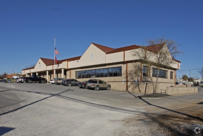
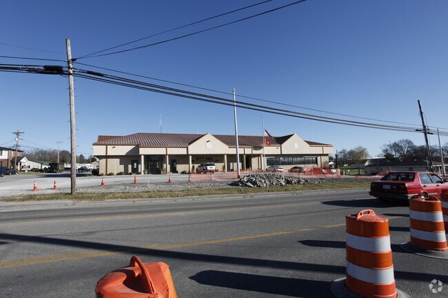
Property Record
2425 N Mount Juliet Rd, Mount Juliet, TN 37122

NEARBY LISTINGS FOR SALE OR LEASE
Property Detail
2425 N Mount Juliet Rd
072I-A-024.00
225 X 260M IRR
Municipalproperty
Wilson
X
Tennessee
47189C0134E
1 AC
0
Wilson County
2024
Nashville
030309
Nashville-Davidson--Murfreesboro--Franklin, TN
15,145 SF
DEMOGRAPHICS near 2425 N Mount Juliet Rd
1 Mile
3 Mile
5 Mile
2024 Total Population
4,217
35,454
84,320
2029 Population
4,974
41,783
95,366
Pop Growth 2024-2029
+ 17.95%
+ 17.85%
+ 13.10%
Average Age
40
38
40
2024 Total Households
1,520
12,715
31,821
HH Growth 2024-2029
+ 17.96%
+ 17.72%
+ 12.45%
Median Household Inc
$89,523
$101,925
$93,425
Avg Household Size
2.70
2.70
2.60
2024 Avg HH Vehicles
2.00
2.00
2.00
Median Home Value
$348,117
$377,737
$356,946
Median Year Built
2000
2003
1998
Nearby Places
Map Layers
Map Styles
 Street
 Aerial
- Restaurants
- Banks
- Shops
- Fitness
- Groceries
PUBLIC TRANSPORTATION
COMMUTER RAIL
Mt Juliet (East Corridor Line - Tennessee Regional Transportation Authority Music City Star (Music City Star))
DRIVE
WALK
Distance
Mt Juliet (East Corridor Line - Tennessee Regional Transportation Authority Music City Star (Music City Star))
2 min
10 min
0.5 mi
Martha (East Corridor Line - Tennessee Regional Transportation Authority Music City Star (Music City Star))
DRIVE
WALK
Distance
Martha (East Corridor Line - Tennessee Regional Transportation Authority Music City Star (Music City Star))
12 min
7.1 mi
AIRPORT
Nashville International
DRIVE
WALK
Distance
Nashville International
20 min
14.0 mi
Nearby Properties
Address
Land Use
TOTAL SIZE
Lot Size
Zoning
Address
Land Use
TOTAL SIZE
Lot Size
Zoning
1,493,463 SF
54.91 AC
Address
Land Use
TOTAL SIZE
Lot Size
Zoning
548,645 SF
28 AC
CI
Address
Land Use
TOTAL SIZE
Lot Size
Zoning
375,981 SF
24.70 AC
Address
Land Use
TOTAL SIZE
Lot Size
Zoning
384,263 SF
27.59 AC
Address
Land Use
TOTAL SIZE
Lot Size
Zoning
1,089,622 SF
81.95 AC
Address
Land Use
TOTAL SIZE
Lot Size
Zoning
611,467 SF
88.97 AC
Address
Land Use
TOTAL SIZE
Lot Size
Zoning
296,500 SF
6.95 AC
Address
Land Use
TOTAL SIZE
Lot Size
Zoning
105,709 SF
11.38 AC
Address
Land Use
TOTAL SIZE
Lot Size
Zoning
197,114 SF
7.01 AC
Address
Land Use
TOTAL SIZE
Lot Size
Zoning
258,534 SF
14.15 AC
Address
Land Use
TOTAL SIZE
Lot Size
Zoning
308,062 SF
20.55 AC
RM16
Address
Land Use
TOTAL SIZE
Lot Size
Zoning
337,419 SF
22.77 AC
Address
Land Use
TOTAL SIZE
Lot Size
Zoning
365,803 SF
20 AC
Address
Land Use
TOTAL SIZE
Lot Size
Zoning
528,580 SF
25 AC
Address
Land Use
TOTAL SIZE
Lot Size
Zoning
232,014 SF
17.89 AC
RM16
Address
Land Use
TOTAL SIZE
Lot Size
Zoning
459,108 SF
41.82 AC
Address
Land Use
TOTAL SIZE
Lot Size
Zoning
183,224 SF
23.62 AC
CMU
Address
Land Use
TOTAL SIZE
Lot Size
Zoning
106,354 SF
4.45 AC
Address
Land Use
TOTAL SIZE
Lot Size
Zoning
104,601 SF
2.42 AC
C1
Address
Land Use
TOTAL SIZE
Lot Size
Zoning
86,013 SF
7 AC
Address
Land Use
TOTAL SIZE
Lot Size
Zoning
102,905 SF
21.42 AC
C1
Address
Land Use
TOTAL SIZE
Lot Size
Zoning
122,364 SF
16.73 AC
CMU
Address
Land Use
TOTAL SIZE
Lot Size
Zoning
104,810 SF
11.44 AC
Address
Land Use
TOTAL SIZE
Lot Size
Zoning
240,415 SF
16.52 AC
Address
Land Use
TOTAL SIZE
Lot Size
Zoning
38,625 SF
13 AC
RS40
Address
Land Use
TOTAL SIZE
Lot Size
Zoning
74,436 SF
2.09 AC
Address
Land Use
TOTAL SIZE
Lot Size
Zoning
95,840 SF
2.78 AC
CMU
Address
Land Use
TOTAL SIZE
Lot Size
Zoning
127,056 SF
11.57 AC
Address
Land Use
TOTAL SIZE
Lot Size
Zoning
73,926 SF
2.10 AC
C1
Address
Land Use
TOTAL SIZE
Lot Size
Zoning
63,995 SF
2.57 AC
The World's #1 Commercial Real Estate Marketplace
Connect with us
© 2025 CoStar Group
The information above has been obtained from sources believed reliable. While we do not doubt its accuracy we have not verified it and make no guarantee, warranty or representation about it. It is your responsibility to independently confirm its accuracy and completeness. Any projections, opinions, assumptions, or estimates used are for example only and do not represent the current or future performance of the property. The value of this transaction to you depends on tax and other factors which should be evaluated by your tax, financial, and legal advisors. You and your advisors should conduct a careful, independent investigation of the property to determine to your satisfaction the suitability of the property for your needs.