Property Record
2425 S 579 Hwy, Wimauma, FL 33598

Property Detail
2425 S 579 Hwy
Tampa-St. Petersburg-Clearwater, FL
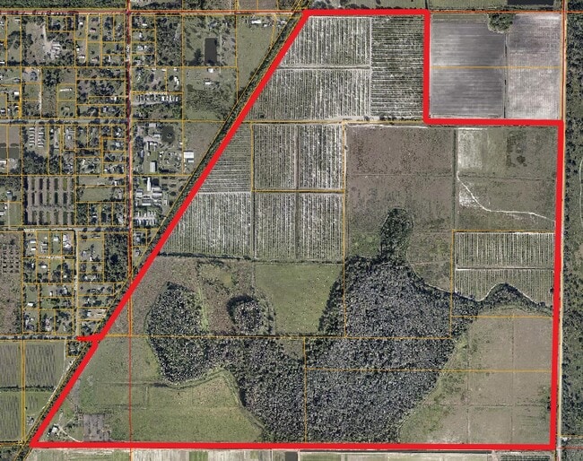
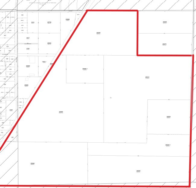
SECTIONS 20 AND 21-32-20 NE 1/4 OF SE 1/4 E OF RR IN SEC 20 AND S 1/2 OF NW 1/4 E OF RR AND N 1/2 OF SW 1/4 E OF RR SEC 21 AND LESS E 1133 FT OF N 845 FT OF THAT PART OF S 1/2 OF NW 1/4 OF SEC 21 LYING E OF SCLRR R/W... S 1/2 OF NE 1/4 AND NW 1/4 OF
U-21-32-20-ZZZ-000003-25490.0
HILLSBOROUGH
Miscellaneous
Florida
PD
25490
AE The base floodplain where base flood elevations are provided. AE Zones are now used on new format FIRMs instead of A1-A30 Zones.
165.08 AC
2024
Eastern Outlying
2025
Tampa/St Petersburg
013914
NEARBY LISTINGS FOR SALE OR LEASE
DEMOGRAPHICS near 2425 S 579 Hwy
1 mile
3 mile
5 mile
2025 Total Population
68
17,465
48,510
2030 Population
77
19,676
53,798
Pop Growth 2025-2030
+ 13.24%
+ 12.66%
+ 10.90%
Average Age
37
39
54
2025 Total Households
20
5,431
21,217
HH Growth 2025-2030
+ 15.00%
+ 12.32%
+ 10.46%
Median Household Inc
$71,249
$71,395
$68,151
Avg Household Size
3.20
3.00
2.20
2025 Avg HH Vehicles
3.00
2.00
2.00
Median Home Value
$425,000
$421,437
$343,293
Median Year Built
2011
2010
1999
Nearby Places
Map Layers
Map Styles
 Street
 Aerial
Layers
 Traffic
 Biking
Places
Listings with unknown addresses are not visible on the map
- Restaurants
- Banks
- Shops
- Fitness
- Groceries
PUBLIC TRANSPORTATION
AIRPORT
Tampa International
Drive
Walk
Distance
Tampa International
54 min
34.3 mi
Sarasota/Bradenton International
Drive
Walk
Distance
Sarasota/Bradenton International
54 min
34.4 mi
St Pete-Clearwater International
Drive
Walk
Distance
St Pete-Clearwater International
71 min
43.5 mi
Freight Ports
Port Manatee
Drive
Walk
Distance
Port Manatee
32 min
18.9 mi
Nearby Properties
Address
Land Use
TOTAL SIZE
Lot Size
Zoning
Address
Land Use
TOTAL SIZE
Lot Size
Zoning
389,356 SF
17.42 AC
PD
Address
Land Use
TOTAL SIZE
Lot Size
Zoning
365,695 SF
17.84 AC
PD-MU
Address
Land Use
TOTAL SIZE
Lot Size
Zoning
2,051.62 AC
AR
Address
Land Use
TOTAL SIZE
Lot Size
Zoning
211,729 SF
33.11 AC
PD
Address
Land Use
TOTAL SIZE
Lot Size
Zoning
295,588 SF
10.80 AC
PD-MU
Address
Land Use
TOTAL SIZE
Lot Size
Zoning
92,585 SF
15.11 AC
PD
Address
Land Use
TOTAL SIZE
Lot Size
Zoning
857.12 AC
AM
Address
Land Use
TOTAL SIZE
Lot Size
Zoning
75,710 SF
10.24 AC
PD
Address
Land Use
TOTAL SIZE
Lot Size
Zoning
100,134 SF
10.45 AC
PD
Address
Land Use
TOTAL SIZE
Lot Size
Zoning
8,897 SF
430.30 AC
AR
Address
Land Use
TOTAL SIZE
Lot Size
Zoning
62,648 SF
19.54 AC
AR
Address
Land Use
TOTAL SIZE
Lot Size
Zoning
49,600 SF
4.54 AC
PD
Address
Land Use
TOTAL SIZE
Lot Size
Zoning
25,340 SF
2.97 AC
CG
Address
Land Use
TOTAL SIZE
Lot Size
Zoning
624 SF
359.68 AC
AR
Address
Land Use
TOTAL SIZE
Lot Size
Zoning
52,776 SF
213.09 AC
PD-MU
Address
Land Use
TOTAL SIZE
Lot Size
Zoning
53,580 SF
12.07 AC
PD-MU
Address
Land Use
TOTAL SIZE
Lot Size
Zoning
4,564 SF
15.53 AC
PD
Address
Land Use
TOTAL SIZE
Lot Size
Zoning
17,616 SF
2.20 AC
CG
Address
Land Use
TOTAL SIZE
Lot Size
Zoning
88,007 SF
11.63 AC
RSC-2
Address
Land Use
TOTAL SIZE
Lot Size
Zoning
27,124 SF
2.99 AC
PD-MU
Address
Land Use
TOTAL SIZE
Lot Size
Zoning
26,274 SF
1.42 AC
PD-MU
Address
Land Use
TOTAL SIZE
Lot Size
Zoning
20,022 SF
2.29 AC
CG
Address
Land Use
TOTAL SIZE
Lot Size
Zoning
21,860 SF
9.96 AC
PD-MU
Address
Land Use
TOTAL SIZE
Lot Size
Zoning
178.64 AC
PD
Address
Land Use
TOTAL SIZE
Lot Size
Zoning
12,148 SF
1.71 AC
PD
Address
Land Use
TOTAL SIZE
Lot Size
Zoning
56.47 AC
PD
Address
Land Use
TOTAL SIZE
Lot Size
Zoning
1,152 SF
276.54 AC
AR
Address
Land Use
TOTAL SIZE
Lot Size
Zoning
6,179 SF
1.76 AC
PD
The World's #1 Commercial Real Estate Marketplace
Connect with us
© 2026 CoStar Group
The information above has been obtained from sources believed reliable. While we do not doubt its accuracy we have not verified it and make no guarantee, warranty or representation about it. It is your responsibility to independently confirm its accuracy and completeness. Any projections, opinions, assumptions, or estimates used are for example only and do not represent the current or future performance of the property. The value of this transaction to you depends on tax and other factors which should be evaluated by your tax, financial, and legal advisors. You and your advisors should conduct a careful, independent investigation of the property to determine to your satisfaction the suitability of the property for your needs.