Property Record
2427 Al Highway 202, Anniston, AL 36201
Current Lease Availabilities
NEARBY LISTINGS FOR SALE OR LEASE
Property Detail
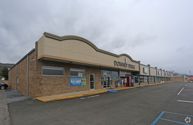
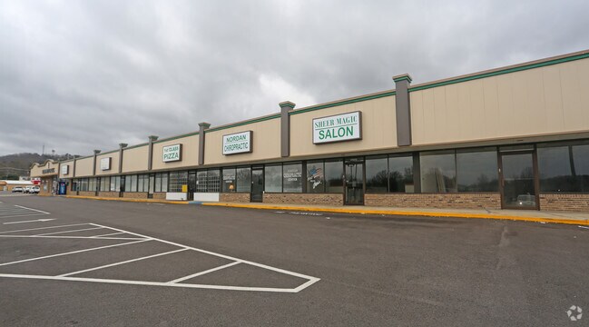
2427 Al Highway 202
22-01-12-3-002-049.000-901
BUILDING ONLY AT OWNERS REQUEST WELLBORN FAMILY PRACTICE WE LLBORN FAMILY PRACTICE
Storesoffices
Calhoun
X
Alabama
01015C0313E
0.83 AC
2025
Gadsden/Anniston Area
2025
Other Market Areas
001300
Anniston-Oxford, AL
5,788 SF
DEMOGRAPHICS near 2427 Al Highway 202
1 Mile
3 Mile
5 Mile
2024 Total Population
2,128
20,391
43,092
2029 Population
2,136
20,534
42,878
Pop Growth 2024-2029
+ 0.38%
+ 0.70%
(0.50%)
Average Age
41
42
41
2024 Total Households
874
8,383
17,772
HH Growth 2024-2029
+ 0.34%
+ 0.78%
(0.53%)
Median Household Inc
$33,579
$30,101
$38,827
Avg Household Size
2.40
2.20
2.30
2024 Avg HH Vehicles
2.00
2.00
2.00
Median Home Value
$60,275
$79,838
$106,476
Median Year Built
1971
1965
1972
Nearby Places
Map Layers
Map Styles
 Street
 Aerial
- Restaurants
- Banks
- Shops
- Fitness
- Groceries
PUBLIC TRANSPORTATION
COMMUTER RAIL
Anniston Amtrak Station (Crescent - Amtrak)
DRIVE
WALK
Distance
Anniston Amtrak Station (Crescent - Amtrak)
4 min
2.5 mi
Freight Ports
Port of Panama City
DRIVE
WALK
Distance
Port of Panama City
364 min
291.4 mi
Nearby Properties
Address
Land Use
TOTAL SIZE
Lot Size
Zoning
Address
Land Use
TOTAL SIZE
Lot Size
Zoning
319,650 SF
10.69 AC
Address
Land Use
TOTAL SIZE
Lot Size
Zoning
12,496 SF
7.39 AC
Address
Land Use
TOTAL SIZE
Lot Size
Zoning
4,520 SF
8.20 AC
Address
Land Use
TOTAL SIZE
Lot Size
Zoning
73,027 SF
1.60 AC
Address
Land Use
TOTAL SIZE
Lot Size
Zoning
21,766 SF
3.06 AC
Address
Land Use
TOTAL SIZE
Lot Size
Zoning
2,728 SF
47 AC
Address
Land Use
TOTAL SIZE
Lot Size
Zoning
17,254 SF
22 AC
Address
Land Use
TOTAL SIZE
Lot Size
Zoning
31,832 SF
16 AC
Address
Land Use
TOTAL SIZE
Lot Size
Zoning
14,082 SF
3.85 AC
Address
Land Use
TOTAL SIZE
Lot Size
Zoning
5,581 SF
1.01 AC
Address
Land Use
TOTAL SIZE
Lot Size
Zoning
3.67 AC
Address
Land Use
TOTAL SIZE
Lot Size
Zoning
12,695 SF
0.75 AC
Address
Land Use
TOTAL SIZE
Lot Size
Zoning
6.94 AC
Address
Land Use
TOTAL SIZE
Lot Size
Zoning
6,400 SF
12.24 AC
Address
Land Use
TOTAL SIZE
Lot Size
Zoning
6,912 SF
12.68 AC
Address
Land Use
TOTAL SIZE
Lot Size
Zoning
34,564 SF
1.60 AC
Address
Land Use
TOTAL SIZE
Lot Size
Zoning
85,305 SF
1.11 AC
Address
Land Use
TOTAL SIZE
Lot Size
Zoning
13,568 SF
1.60 AC
Address
Land Use
TOTAL SIZE
Lot Size
Zoning
40,520 SF
4.01 AC
Address
Land Use
TOTAL SIZE
Lot Size
Zoning
8,032 SF
10.30 AC
Address
Land Use
TOTAL SIZE
Lot Size
Zoning
47,164 SF
1.37 AC
Address
Land Use
TOTAL SIZE
Lot Size
Zoning
Address
Land Use
TOTAL SIZE
Lot Size
Zoning
65,545 SF
0.80 AC
Address
Land Use
TOTAL SIZE
Lot Size
Zoning
93,926 SF
26.88 AC
Address
Land Use
TOTAL SIZE
Lot Size
Zoning
48,263 SF
4.05 AC
Address
Land Use
TOTAL SIZE
Lot Size
Zoning
6,032 SF
41 AC
Address
Land Use
TOTAL SIZE
Lot Size
Zoning
51,372 SF
0.91 AC
Address
Land Use
TOTAL SIZE
Lot Size
Zoning
15,884 SF
0.46 AC
Address
Land Use
TOTAL SIZE
Lot Size
Zoning
21,310 SF
0.57 AC
Address
Land Use
TOTAL SIZE
Lot Size
Zoning
38,812 SF
0.92 AC
The World's #1 Commercial Real Estate Marketplace
Connect with us
© 2026 CoStar Group
The information above has been obtained from sources believed reliable. While we do not doubt its accuracy we have not verified it and make no guarantee, warranty or representation about it. It is your responsibility to independently confirm its accuracy and completeness. Any projections, opinions, assumptions, or estimates used are for example only and do not represent the current or future performance of the property. The value of this transaction to you depends on tax and other factors which should be evaluated by your tax, financial, and legal advisors. You and your advisors should conduct a careful, independent investigation of the property to determine to your satisfaction the suitability of the property for your needs.