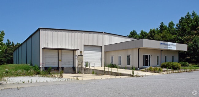
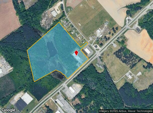
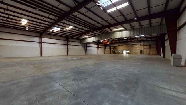
Property Record
2428 Nc Highway 11 N, Kinston, NC 28501
Current Lease Availabilities
NEARBY LISTINGS FOR SALE OR LEASE
Property Detail
2428 Nc Highway 11 N
453603346751
HWY 11 NORTH MOST WOODS LOW/WET
Storebuilding
Lenoir
AE
North Carolina
3720453600K
31.21 AC
2025
North Carolina Southeast Area
2025
Other Market Areas
010100
Kinston, NC
17,010 SF
DEMOGRAPHICS near 2428 Nc Highway 11 N
1 Mile
3 Mile
5 Mile
2024 Total Population
273
14,913
24,057
2029 Population
267
15,004
24,024
Pop Growth 2024-2029
(2.20%)
+ 0.61%
(0.14%)
Average Age
45
42
43
2024 Total Households
118
6,568
10,401
HH Growth 2024-2029
(1.69%)
+ 0.67%
(0.12%)
Median Household Inc
$34,021
$29,481
$34,181
Avg Household Size
2.30
2.20
2.20
2024 Avg HH Vehicles
3.00
1.00
1.00
Median Home Value
$57,352
$76,478
$91,392
Median Year Built
1977
1966
1969
Nearby Places
- Restaurants
- Banks
- Shops
- Fitness
- Groceries
PUBLIC TRANSPORTATION
AIRPORT
Pitt-Greenville
DRIVE
WALK
Distance
Pitt-Greenville
40 min
32.3 mi
Freight Ports
Port of Morehead City
DRIVE
WALK
Distance
Port of Morehead City
114 min
79.3 mi
Nearby Properties
Address
Land Use
TOTAL SIZE
Lot Size
Zoning
Address
Land Use
TOTAL SIZE
Lot Size
Zoning
274,824 SF
54.92 AC
OI
Address
Land Use
TOTAL SIZE
Lot Size
Zoning
114,876 SF
64.24 AC
RA6
Address
Land Use
TOTAL SIZE
Lot Size
Zoning
37,588 SF
111.16 AC
Address
Land Use
TOTAL SIZE
Lot Size
Zoning
191,518 SF
20.71 AC
SC
Address
Land Use
TOTAL SIZE
Lot Size
Zoning
144,099 SF
23.48 AC
RA8
Address
Land Use
TOTAL SIZE
Lot Size
Zoning
119,634 SF
1.86 AC
B2
Address
Land Use
TOTAL SIZE
Lot Size
Zoning
51,934 SF
0.32 AC
B2
Address
Land Use
TOTAL SIZE
Lot Size
Zoning
5,664 SF
407.13 AC
RA6
Address
Land Use
TOTAL SIZE
Lot Size
Zoning
53,768 SF
33.29 AC
I1
Address
Land Use
TOTAL SIZE
Lot Size
Zoning
18,213 SF
159.12 AC
OI
Address
Land Use
TOTAL SIZE
Lot Size
Zoning
23,086 SF
7.39 AC
RA5
Address
Land Use
TOTAL SIZE
Lot Size
Zoning
44,800 SF
9.75 AC
O&I
Address
Land Use
TOTAL SIZE
Lot Size
Zoning
6,178 SF
6.33 AC
RA5
Address
Land Use
TOTAL SIZE
Lot Size
Zoning
11,270 SF
112 AC
RA6
Address
Land Use
TOTAL SIZE
Lot Size
Zoning
64,506 SF
10.64 AC
I1
Address
Land Use
TOTAL SIZE
Lot Size
Zoning
8,640 SF
8.03 AC
RA5
Address
Land Use
TOTAL SIZE
Lot Size
Zoning
83,088 SF
1.19 AC
B2
Address
Land Use
TOTAL SIZE
Lot Size
Zoning
5,206 SF
53.41 AC
IB
Address
Land Use
TOTAL SIZE
Lot Size
Zoning
290,820 SF
25.95 AC
I1
Address
Land Use
TOTAL SIZE
Lot Size
Zoning
3,724 SF
8.84 AC
RA5
Address
Land Use
TOTAL SIZE
Lot Size
Zoning
51,828 SF
7.05 AC
O&I
Address
Land Use
TOTAL SIZE
Lot Size
Zoning
6,760 SF
147.39 AC
RA6
Address
Land Use
TOTAL SIZE
Lot Size
Zoning
7,140 SF
5.04 AC
Address
Land Use
TOTAL SIZE
Lot Size
Zoning
14,651 SF
2.85 AC
B1
Address
Land Use
TOTAL SIZE
Lot Size
Zoning
31,335 SF
9.96 AC
SC
Address
Land Use
TOTAL SIZE
Lot Size
Zoning
8,680 SF
12.35 AC
RA5
Address
Land Use
TOTAL SIZE
Lot Size
Zoning
51,447 SF
5.84 AC
SC
Address
Land Use
TOTAL SIZE
Lot Size
Zoning
112,564 SF
29.12 AC
I1
Address
Land Use
TOTAL SIZE
Lot Size
Zoning
78,432 SF
6.66 AC
Address
Land Use
TOTAL SIZE
Lot Size
Zoning
18,716 SF
276.57 AC
RA6
The World's #1 Commercial Real Estate Marketplace
Connect with us
© 2025 CoStar Group
The information above has been obtained from sources believed reliable. While we do not doubt its accuracy we have not verified it and make no guarantee, warranty or representation about it. It is your responsibility to independently confirm its accuracy and completeness. Any projections, opinions, assumptions, or estimates used are for example only and do not represent the current or future performance of the property. The value of this transaction to you depends on tax and other factors which should be evaluated by your tax, financial, and legal advisors. You and your advisors should conduct a careful, independent investigation of the property to determine to your satisfaction the suitability of the property for your needs.