Property Record
2428 W Meyer Rd, Wentzville, MO 63385
NEARBY LISTINGS FOR SALE OR LEASE
Property Detail
2428 W Meyer Rd
St. Louis, MO-IL
PT NE 1/4
4-0014-S021-00-0006.7000000
St. Charles
Sfr
Missouri
2024
6
2025
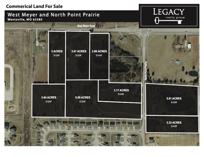
3.87 AC
312003
St Charles County
2,240 SF
St. Louis
DEMOGRAPHICS near 2428 W Meyer Rd
1 Mile
3 Mile
5 Mile
2024 Total Population
5,623
30,872
55,733
2029 Population
5,980
32,916
59,324
Pop Growth 2024-2029
+ 6.35%
+ 6.62%
+ 6.44%
Average Age
37
38
38
2024 Total Households
1,816
10,709
19,260
HH Growth 2024-2029
+ 6.39%
+ 6.75%
+ 6.60%
Median Household Inc
$117,525
$100,549
$100,718
Avg Household Size
3.10
2.90
2.90
2024 Avg HH Vehicles
2.00
2.00
2.00
Median Home Value
$310,569
$299,477
$300,926
Median Year Built
2008
2007
2006
Nearby Places
Map Layers
Map Styles
 Street
 Aerial
- Restaurants
- Banks
- Shops
- Fitness
- Groceries
SALE & LEASE HISTORY
LISTING DATE
SALE/LEASE

Feb 06, 2025
For Sale
Nearby Properties
Address
Land Use
TOTAL SIZE
Lot Size
Zoning
Address
Land Use
TOTAL SIZE
Lot Size
Zoning
420,000 SF
20.75 AC
Address
Land Use
TOTAL SIZE
Lot Size
Zoning
235,850 SF
12.97 AC
Address
Land Use
TOTAL SIZE
Lot Size
Zoning
165,953 SF
14 AC
Address
Land Use
TOTAL SIZE
Lot Size
Zoning
215,329 SF
19.29 AC
Address
Land Use
TOTAL SIZE
Lot Size
Zoning
285,050 SF
20.84 AC
Address
Land Use
TOTAL SIZE
Lot Size
Zoning
28.69 AC
Address
Land Use
TOTAL SIZE
Lot Size
Zoning
140,375 SF
13.17 AC
Address
Land Use
TOTAL SIZE
Lot Size
Zoning
69,965 SF
8.09 AC
Address
Land Use
TOTAL SIZE
Lot Size
Zoning
136,594 SF
14.44 AC
Address
Land Use
TOTAL SIZE
Lot Size
Zoning
126,308 SF
11.63 AC
Address
Land Use
TOTAL SIZE
Lot Size
Zoning
18.75 AC
Address
Land Use
TOTAL SIZE
Lot Size
Zoning
124,200 SF
5.99 AC
Address
Land Use
TOTAL SIZE
Lot Size
Zoning
3,696 SF
53.65 AC
Address
Land Use
TOTAL SIZE
Lot Size
Zoning
52,222 SF
1.68 AC
Address
Land Use
TOTAL SIZE
Lot Size
Zoning
54,059 SF
2.06 AC
Address
Land Use
TOTAL SIZE
Lot Size
Zoning
73.30 AC
AB7
Address
Land Use
TOTAL SIZE
Lot Size
Zoning
30.56 AC
AA1
Address
Land Use
TOTAL SIZE
Lot Size
Zoning
106,800 SF
11.57 AC
Address
Land Use
TOTAL SIZE
Lot Size
Zoning
71.24 AC
Address
Land Use
TOTAL SIZE
Lot Size
Zoning
74,509 SF
7.98 AC
Address
Land Use
TOTAL SIZE
Lot Size
Zoning
70,978 SF
1.98 AC
Address
Land Use
TOTAL SIZE
Lot Size
Zoning
21.22 AC
Address
Land Use
TOTAL SIZE
Lot Size
Zoning
67.52 AC
AA1
Address
Land Use
TOTAL SIZE
Lot Size
Zoning
79,005 SF
6.04 AC
Address
Land Use
TOTAL SIZE
Lot Size
Zoning
88,693 SF
6.54 AC
Address
Land Use
TOTAL SIZE
Lot Size
Zoning
12,280 SF
16.61 AC
Address
Land Use
TOTAL SIZE
Lot Size
Zoning
9,547 SF
1.21 AC
Address
Land Use
TOTAL SIZE
Lot Size
Zoning
55,408 SF
5.23 AC
Address
Land Use
TOTAL SIZE
Lot Size
Zoning
26,400 SF
15.73 AC
Address
Land Use
TOTAL SIZE
Lot Size
Zoning
82,859 SF
4.98 AC
The World's #1 Commercial Real Estate Marketplace
Connect with us
© 2026 CoStar Group
The information above has been obtained from sources believed reliable. While we do not doubt its accuracy we have not verified it and make no guarantee, warranty or representation about it. It is your responsibility to independently confirm its accuracy and completeness. Any projections, opinions, assumptions, or estimates used are for example only and do not represent the current or future performance of the property. The value of this transaction to you depends on tax and other factors which should be evaluated by your tax, financial, and legal advisors. You and your advisors should conduct a careful, independent investigation of the property to determine to your satisfaction the suitability of the property for your needs.