Property Record
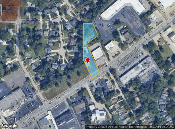
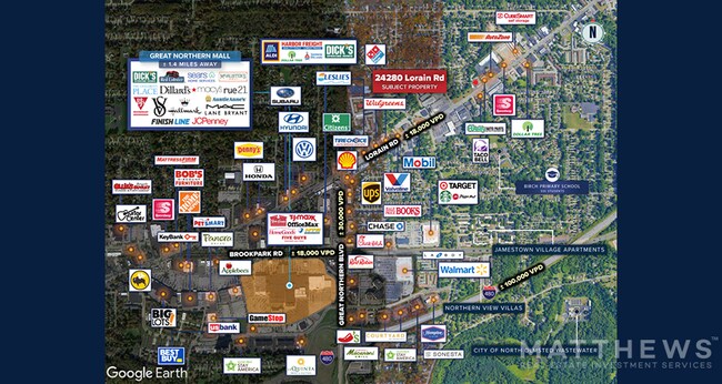
24280 Lorain Rd, North Olmsted, OH 44070

NEARBY LISTINGS FOR SALE OR LEASE
Property Detail
24280 Lorain Rd
Cleveland-Elyria, OH
Dover
231-31-006
19 EP 590.58FT E OF WALTER RD
Bartavern
Cuyahoga
X
Ohio
39035C0142E
19
2024
1.38 AC
2024
West
174106
Cleveland
6,516 SF
DEMOGRAPHICS near 24280 Lorain Rd
1 Mile
3 Mile
5 Mile
2024 Total Population
12,405
64,407
176,285
2029 Population
12,061
62,576
171,690
Pop Growth 2024-2029
(2.77%)
(2.84%)
(2.61%)
Average Age
42
44
44
2024 Total Households
5,450
27,900
76,362
HH Growth 2024-2029
(2.97%)
(3.02%)
(2.78%)
Median Household Inc
$68,741
$77,452
$76,125
Avg Household Size
2.20
2.20
2.20
2024 Avg HH Vehicles
2.00
2.00
2.00
Median Home Value
$168,328
$205,961
$209,669
Median Year Built
1963
1965
1964
Nearby Places
Map Layers
Map Styles
 Street
 Aerial
- Restaurants
- Banks
- Shops
- Fitness
- Groceries
PUBLIC TRANSPORTATION
AIRPORT
Cleveland-Hopkins International
DRIVE
WALK
Distance
Cleveland-Hopkins International
9 min
3.6 mi
Freight Ports
Port of Toledo
DRIVE
WALK
Distance
Port of Toledo
119 min
100.1 mi
SALE & LEASE HISTORY
LISTING DATE
SALE/LEASE

Jun 09, 2023
For Lease
Nearby Properties
Address
Land Use
TOTAL SIZE
Lot Size
Zoning
Address
Land Use
TOTAL SIZE
Lot Size
Zoning
748.88 AC
GI
Address
Land Use
TOTAL SIZE
Lot Size
Zoning
1,669,041 SF
169.42 AC
U6
Address
Land Use
TOTAL SIZE
Lot Size
Zoning
263,090 SF
33.53 AC
GB-A
Address
Land Use
TOTAL SIZE
Lot Size
Zoning
327,732 SF
57.22 AC
1F
Address
Land Use
TOTAL SIZE
Lot Size
Zoning
321,868 SF
71.81 AC
Address
Land Use
TOTAL SIZE
Lot Size
Zoning
657,013 SF
48.88 AC
SI
Address
Land Use
TOTAL SIZE
Lot Size
Zoning
354,041 SF
6.16 AC
F-1F80
Address
Land Use
TOTAL SIZE
Lot Size
Zoning
154,058 SF
29.97 AC
Address
Land Use
TOTAL SIZE
Lot Size
Zoning
457,220 SF
41.84 AC
CRG
Address
Land Use
TOTAL SIZE
Lot Size
Zoning
126,640 SF
93.63 AC
Address
Land Use
TOTAL SIZE
Lot Size
Zoning
633,719 SF
17.16 AC
CRG
Address
Land Use
TOTAL SIZE
Lot Size
Zoning
1,391,445 SF
136.05 AC
GI
Address
Land Use
TOTAL SIZE
Lot Size
Zoning
49.67 AC
SI
Address
Land Use
TOTAL SIZE
Lot Size
Zoning
230,687 SF
15.98 AC
Address
Land Use
TOTAL SIZE
Lot Size
Zoning
36,844 SF
13.44 AC
EOP
Address
Land Use
TOTAL SIZE
Lot Size
Zoning
14.60 AC
1F-4
Address
Land Use
TOTAL SIZE
Lot Size
Zoning
193,858 SF
19.65 AC
R-MF24
Address
Land Use
TOTAL SIZE
Lot Size
Zoning
90,324 SF
6.71 AC
GR
Address
Land Use
TOTAL SIZE
Lot Size
Zoning
64,528 SF
17.67 AC
1F-4
Address
Land Use
TOTAL SIZE
Lot Size
Zoning
235,984 SF
18.10 AC
GB
Address
Land Use
TOTAL SIZE
Lot Size
Zoning
102,512 SF
5.17 AC
CR
Address
Land Use
TOTAL SIZE
Lot Size
Zoning
123,093 SF
7.31 AC
MFS
Address
Land Use
TOTAL SIZE
Lot Size
Zoning
24.55 AC
GI
Address
Land Use
TOTAL SIZE
Lot Size
Zoning
103,795 SF
19.39 AC
F-1F80
Address
Land Use
TOTAL SIZE
Lot Size
Zoning
244,602 SF
10.31 AC
CR
Address
Land Use
TOTAL SIZE
Lot Size
Zoning
89,148 SF
52.94 AC
Address
Land Use
TOTAL SIZE
Lot Size
Zoning
130,030 SF
5.69 AC
RMF-A
Address
Land Use
TOTAL SIZE
Lot Size
Zoning
37.26 AC
SI
Address
Land Use
TOTAL SIZE
Lot Size
Zoning
68,600 SF
58.22 AC
U6
Address
Land Use
TOTAL SIZE
Lot Size
Zoning
93,595 SF
7.46 AC
MFS
The World's #1 Commercial Real Estate Marketplace
Connect with us
© 2025 CoStar Group
The information above has been obtained from sources believed reliable. While we do not doubt its accuracy we have not verified it and make no guarantee, warranty or representation about it. It is your responsibility to independently confirm its accuracy and completeness. Any projections, opinions, assumptions, or estimates used are for example only and do not represent the current or future performance of the property. The value of this transaction to you depends on tax and other factors which should be evaluated by your tax, financial, and legal advisors. You and your advisors should conduct a careful, independent investigation of the property to determine to your satisfaction the suitability of the property for your needs.