Property Record
243 Central Rd, Rye, NH 03870
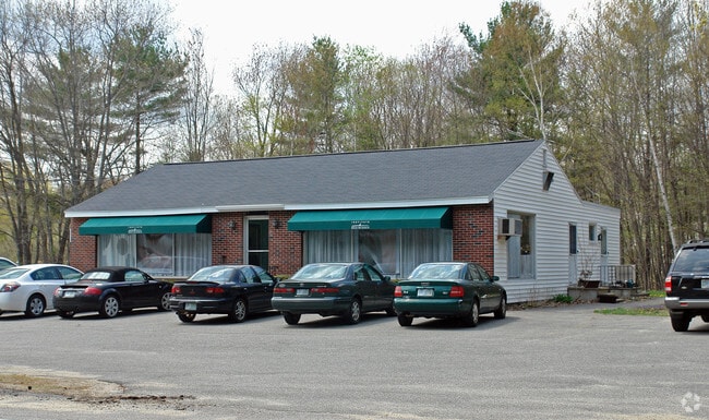

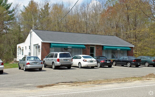
Property Detail
243 Central Rd
Financialbuilding
ROCKINGHAM
COM
New Hampshire
B and X Area of moderate flood hazard, usually the area between the limits of the 100-year and 500-year floods.
1.80 AC
2024
Rockingham
2024
Boston
071001
Boston-Cambridge-Newton, MA-NH
3,384 SF
RYEE-000008-000000-000013
NEARBY LISTINGS FOR SALE OR LEASE
DEMOGRAPHICS near 243 Central Rd
1 mile
3 mile
5 mile
2024 Total Population
1,608
12,110
35,856
2029 Population
1,659
12,400
36,647
Pop Growth 2024-2029
+ 3.17%
+ 2.39%
+ 2.21%
Average Age
52
47
47
2024 Total Households
693
5,365
15,666
HH Growth 2024-2029
+ 3.03%
+ 2.29%
+ 2.10%
Median Household Inc
$135,810
$112,442
$116,081
Avg Household Size
2.20
2.20
2.20
2024 Avg HH Vehicles
2.00
2.00
2.00
Median Home Value
$1,079,388
$813,454
$756,767
Median Year Built
1975
1980
1972
Nearby Places
Map Layers
Map Styles
 Street
 Aerial
Transit
 Traffic
 Biking
Places
Listings with unknown addresses are not visible on the map
- Restaurants
- Banks
- Shops
- Fitness
- Groceries
PUBLIC TRANSPORTATION
AIRPORT
Portsmouth International at Pease
Drive
Walk
Distance
Portsmouth International at Pease
20 min
8.3 mi
Freight Ports
Port of Boston
Drive
Walk
Distance
Port of Boston
85 min
56.2 mi
Nearby Properties
Address
Land Use
TOTAL SIZE
Lot Size
Zoning
Address
Land Use
TOTAL SIZE
Lot Size
Zoning
35.53 AC
GA/MH
Address
Land Use
TOTAL SIZE
Lot Size
Zoning
28.05 AC
GA/MH
Address
Land Use
TOTAL SIZE
Lot Size
Zoning
114,194 SF
G1
Address
Land Use
TOTAL SIZE
Lot Size
Zoning
25.08 AC
NRP
Address
Land Use
TOTAL SIZE
Lot Size
Zoning
4,776 SF
19.32 AC
PREC
Address
Land Use
TOTAL SIZE
Lot Size
Zoning
190,444 SF
20.38 AC
G1
Address
Land Use
TOTAL SIZE
Lot Size
Zoning
7.16 AC
GA/MH
Address
Land Use
TOTAL SIZE
Lot Size
Zoning
53,008 SF
17.70 AC
SRES
Address
Land Use
TOTAL SIZE
Lot Size
Zoning
72,193 SF
G1
Address
Land Use
TOTAL SIZE
Lot Size
Zoning
72,694 SF
36.70 AC
I
Address
Land Use
TOTAL SIZE
Lot Size
Zoning
85,152 SF
13.04 AC
G1
Address
Land Use
TOTAL SIZE
Lot Size
Zoning
207,279 SF
33.07 AC
I
Address
Land Use
TOTAL SIZE
Lot Size
Zoning
53,616 SF
19.17 AC
M
Address
Land Use
TOTAL SIZE
Lot Size
Zoning
Address
Land Use
TOTAL SIZE
Lot Size
Zoning
134,204 SF
G1
Address
Land Use
TOTAL SIZE
Lot Size
Zoning
1,740 SF
67.09 AC
GA/MH
Address
Land Use
TOTAL SIZE
Lot Size
Zoning
21,318 SF
3.98 AC
OR
Address
Land Use
TOTAL SIZE
Lot Size
Zoning
64.57 AC
I
Address
Land Use
TOTAL SIZE
Lot Size
Zoning
3.80 AC
G1
Address
Land Use
TOTAL SIZE
Lot Size
Zoning
6,572 SF
1.20 AC
SRES
Address
Land Use
TOTAL SIZE
Lot Size
Zoning
4.79 AC
I
Address
Land Use
TOTAL SIZE
Lot Size
Zoning
69,745 SF
85.26 AC
R2
Address
Land Use
TOTAL SIZE
Lot Size
Zoning
33,716 SF
G1
Address
Land Use
TOTAL SIZE
Lot Size
Zoning
52,758 SF
8.08 AC
SRES
Address
Land Use
TOTAL SIZE
Lot Size
Zoning
34,359 SF
10.15 AC
COM
Address
Land Use
TOTAL SIZE
Lot Size
Zoning
20,488 SF
6.33 AC
OR
Address
Land Use
TOTAL SIZE
Lot Size
Zoning
1,699 SF
9.61 AC
IB/R
Address
Land Use
TOTAL SIZE
Lot Size
Zoning
6,510 SF
36.41 AC
GRES
Address
Land Use
TOTAL SIZE
Lot Size
Zoning
62,322 SF
5.55 AC
I
Address
Land Use
TOTAL SIZE
Lot Size
Zoning
6,428 SF
2.36 AC
GRES
The World's #1 Commercial Real Estate Marketplace
Connect with us
© 2026 CoStar Group
The information above has been obtained from sources believed reliable. While we do not doubt its accuracy we have not verified it and make no guarantee, warranty or representation about it. It is your responsibility to independently confirm its accuracy and completeness. Any projections, opinions, assumptions, or estimates used are for example only and do not represent the current or future performance of the property. The value of this transaction to you depends on tax and other factors which should be evaluated by your tax, financial, and legal advisors. You and your advisors should conduct a careful, independent investigation of the property to determine to your satisfaction the suitability of the property for your needs.