Property Record
243 Dahlia Ave, Imperial Beach, CA 91932
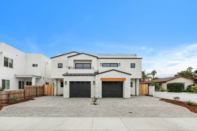
This Property Is For Sale
NEARBY LISTINGS FOR SALE OR LEASE
Property Detail
243 Dahlia Ave
San Diego-Carlsbad, CA
Silver Strand Beach Gardens
625-202-05
San Diego
Sfr
California
X
0.12 AC
06073C2134H
Imperial Beach
1,247 SF
San Diego
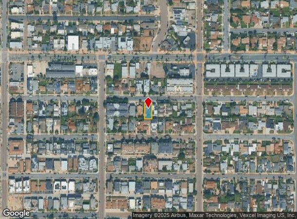
DEMOGRAPHICS near 243 Dahlia Ave
1 Mile
3 Mile
5 Mile
2024 Total Population
13,188
54,330
186,789
2029 Population
13,376
54,491
186,532
Pop Growth 2024-2029
+ 1.43%
+ 0.30%
(0.14%)
Average Age
40
39
39
2024 Total Households
5,161
17,788
57,861
HH Growth 2024-2029
+ 1.45%
+ 0.31%
(0.20%)
Median Household Inc
$98,992
$81,879
$75,157
Avg Household Size
2.50
2.90
3.10
2024 Avg HH Vehicles
2.00
2.00
2.00
Median Home Value
$848,199
$741,607
$657,050
Median Year Built
1972
1975
1972
Nearby Places
Map Layers
Map Styles
 Street
 Aerial
- Restaurants
- Banks
- Shops
- Fitness
- Groceries
PUBLIC TRANSPORTATION
AIRPORT
San Diego International
DRIVE
WALK
Distance
San Diego International
24 min
17.0 mi
Freight Ports
Port of San Diego
DRIVE
WALK
Distance
Port of San Diego
19 min
13.0 mi
Nearby Properties
Address
Land Use
TOTAL SIZE
Lot Size
Zoning
Address
Land Use
TOTAL SIZE
Lot Size
Zoning
8.48 AC
RM-2-5
Address
Land Use
TOTAL SIZE
Lot Size
Zoning
6.67 AC
RM-2-5
Address
Land Use
TOTAL SIZE
Lot Size
Zoning
7.52 AC
CTP
Address
Land Use
TOTAL SIZE
Lot Size
Zoning
7.36 AC
RM-2-5
Address
Land Use
TOTAL SIZE
Lot Size
Zoning
77,573 SF
1.13 AC
C/MU-2
Address
Land Use
TOTAL SIZE
Lot Size
Zoning
5.28 AC
CC-4-5
Address
Land Use
TOTAL SIZE
Lot Size
Zoning
9.10 AC
RM-1-1
Address
Land Use
TOTAL SIZE
Lot Size
Zoning
4.38 AC
RM-2-5
Address
Land Use
TOTAL SIZE
Lot Size
Zoning
70,161 SF
4.66 AC
RM-2-5
Address
Land Use
TOTAL SIZE
Lot Size
Zoning
76,216 SF
2 AC
R-1-6000
Address
Land Use
TOTAL SIZE
Lot Size
Zoning
65,960 SF
4.92 AC
RM-1-1
Address
Land Use
TOTAL SIZE
Lot Size
Zoning
72,824 SF
3.43 AC
RM-3-7
Address
Land Use
TOTAL SIZE
Lot Size
Zoning
45,582 SF
1.28 AC
R-2000
Address
Land Use
TOTAL SIZE
Lot Size
Zoning
7.39 AC
CC-2-3
Address
Land Use
TOTAL SIZE
Lot Size
Zoning
62,284 SF
1.40 AC
C-MU-1
Address
Land Use
TOTAL SIZE
Lot Size
Zoning
53,878 SF
2.23 AC
RM-3-7
Address
Land Use
TOTAL SIZE
Lot Size
Zoning
77,002 SF
7.07 AC
COP
Address
Land Use
TOTAL SIZE
Lot Size
Zoning
43,000 SF
2.70 AC
RM-1-1
Address
Land Use
TOTAL SIZE
Lot Size
Zoning
90,983 SF
2.03 AC
PRV
Address
Land Use
TOTAL SIZE
Lot Size
Zoning
37,476 SF
1.54 AC
R-2000
Address
Land Use
TOTAL SIZE
Lot Size
Zoning
33,392 SF
0.92 AC
R-2000
Address
Land Use
TOTAL SIZE
Lot Size
Zoning
3,027 SF
4.70 AC
R-3000
Address
Land Use
TOTAL SIZE
Lot Size
Zoning
46,184 SF
1.63 AC
CC-1-3
Address
Land Use
TOTAL SIZE
Lot Size
Zoning
66,884 SF
1.59 AC
R-2000
Address
Land Use
TOTAL SIZE
Lot Size
Zoning
72,044 SF
4.63 AC
IP
Address
Land Use
TOTAL SIZE
Lot Size
Zoning
75,000 SF
6.89 AC
CC-2-3
Address
Land Use
TOTAL SIZE
Lot Size
Zoning
62,610 SF
3.14 AC
R-1500
Address
Land Use
TOTAL SIZE
Lot Size
Zoning
9.08 AC
ILP
Address
Land Use
TOTAL SIZE
Lot Size
Zoning
44,100 SF
1.07 AC
CC-1-3
Address
Land Use
TOTAL SIZE
Lot Size
Zoning
1.66 AC
R-1500
The World's #1 Commercial Real Estate Marketplace
Connect with us
© 2025 CoStar Group
The information above has been obtained from sources believed reliable. While we do not doubt its accuracy we have not verified it and make no guarantee, warranty or representation about it. It is your responsibility to independently confirm its accuracy and completeness. Any projections, opinions, assumptions, or estimates used are for example only and do not represent the current or future performance of the property. The value of this transaction to you depends on tax and other factors which should be evaluated by your tax, financial, and legal advisors. You and your advisors should conduct a careful, independent investigation of the property to determine to your satisfaction the suitability of the property for your needs.