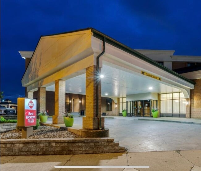
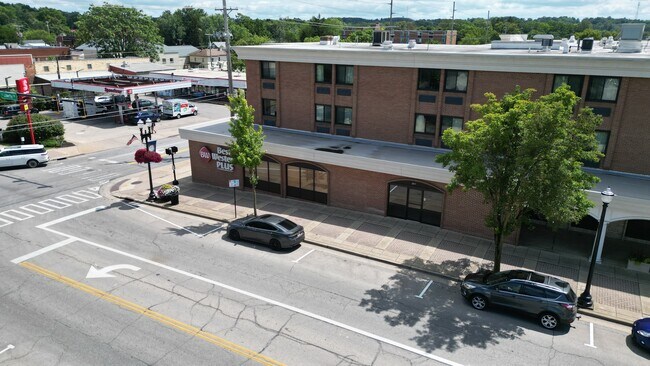
Property Record
243 E Liberty St, Wooster, OH 44691

Current Lease Availabilities
Property Detail
243 E Liberty St
64-00018-000
LOT 5593 260.9' MP 29 PT VAC ALY CD 24
Hotel
Wayne
C4
Ohio
B and X Area of moderate flood hazard, usually the area between the limits of the 100-year and 500-year floods.
5593
2025
1.11 AC
2025
Ohio North Area
000600
Other Market Areas
76,323 SF
Wooster, OH
NEARBY LISTINGS FOR SALE OR LEASE
-
-
View all Wooster listings for lease on LoopNet.com
DEMOGRAPHICS near 243 E Liberty St
1 mile
3 mile
5 mile
2025 Total Population
8,959
28,299
38,455
2030 Population
9,002
28,419
38,595
Pop Growth 2025-2030
+ 0.48%
+ 0.42%
+ 0.36%
Average Age
38
40
41
2025 Total Households
3,545
11,322
15,532
HH Growth 2025-2030
+ 0.42%
+ 0.43%
+ 0.35%
Median Household Inc
$56,033
$66,527
$67,925
Avg Household Size
2.20
2.20
2.20
2025 Avg HH Vehicles
1.00
2.00
2.00
Median Home Value
$151,177
$215,102
$229,663
Median Year Built
1948
1970
1974
Nearby Places
Map Layers
Map Styles
 Street
 Aerial
Layers
 Traffic
 Biking
Places
Listings with unknown addresses are not visible on the map
- Restaurants
- Banks
- Shops
- Fitness
- Groceries
PUBLIC TRANSPORTATION
AIRPORT
Akron-Canton Regional
Drive
Walk
Distance
Akron-Canton Regional
53 min
42.3 mi
Freight Ports
Port of Toledo
Drive
Walk
Distance
Port of Toledo
163 min
118.7 mi
Nearby Properties
Address
Land Use
TOTAL SIZE
Lot Size
Zoning
Address
Land Use
TOTAL SIZE
Lot Size
Zoning
3,488 SF
43.72 AC
CF
Address
Land Use
TOTAL SIZE
Lot Size
Zoning
70,726 SF
9 AC
CF
Address
Land Use
TOTAL SIZE
Lot Size
Zoning
2,268 SF
106.60 AC
CF
Address
Land Use
TOTAL SIZE
Lot Size
Zoning
152,523 SF
74.14 AC
CF
Address
Land Use
TOTAL SIZE
Lot Size
Zoning
81,133 SF
41.43 AC
CF
Address
Land Use
TOTAL SIZE
Lot Size
Zoning
7.28 AC
CF
Address
Land Use
TOTAL SIZE
Lot Size
Zoning
2,400 SF
99.04 AC
CF
Address
Land Use
TOTAL SIZE
Lot Size
Zoning
48,096 SF
1.67 AC
C4
Address
Land Use
TOTAL SIZE
Lot Size
Zoning
109.56 AC
M2
Address
Land Use
TOTAL SIZE
Lot Size
Zoning
50,110 SF
19.26 AC
CF
Address
Land Use
TOTAL SIZE
Lot Size
Zoning
25.14 AC
CF
Address
Land Use
TOTAL SIZE
Lot Size
Zoning
62,910 SF
11.24 AC
C5
Address
Land Use
TOTAL SIZE
Lot Size
Zoning
47,160 SF
3.22 AC
C4
Address
Land Use
TOTAL SIZE
Lot Size
Zoning
4,486 SF
5.57 AC
CF
Address
Land Use
TOTAL SIZE
Lot Size
Zoning
210,000 SF
20 AC
Address
Land Use
TOTAL SIZE
Lot Size
Zoning
2,536 SF
16.79 AC
R4
Address
Land Use
TOTAL SIZE
Lot Size
Zoning
85,910 SF
4.33 AC
Address
Land Use
TOTAL SIZE
Lot Size
Zoning
105,000 SF
25.29 AC
M2
Address
Land Use
TOTAL SIZE
Lot Size
Zoning
62,976 SF
10.46 AC
CF
Address
Land Use
TOTAL SIZE
Lot Size
Zoning
302,400 SF
24.51 AC
M2
Address
Land Use
TOTAL SIZE
Lot Size
Zoning
71,631 SF
17.88 AC
M1
Address
Land Use
TOTAL SIZE
Lot Size
Zoning
58,600 SF
6.30 AC
CF
Address
Land Use
TOTAL SIZE
Lot Size
Zoning
81,724 SF
19.59 AC
CF
Address
Land Use
TOTAL SIZE
Lot Size
Zoning
10.68 AC
M3
Address
Land Use
TOTAL SIZE
Lot Size
Zoning
71,511 SF
9.53 AC
CF
Address
Land Use
TOTAL SIZE
Lot Size
Zoning
36,220 SF
2.68 AC
R1
Address
Land Use
TOTAL SIZE
Lot Size
Zoning
102,500 SF
13.95 AC
M2
Address
Land Use
TOTAL SIZE
Lot Size
Zoning
6,631 SF
7.18 AC
R4
Address
Land Use
TOTAL SIZE
Lot Size
Zoning
25,920 SF
42 AC
CF
Address
Land Use
TOTAL SIZE
Lot Size
Zoning
89,980 SF
17.58 AC
M2
The World's #1 Commercial Real Estate Marketplace
Connect with us
© 2026 CoStar Group
The information above has been obtained from sources believed reliable. While we do not doubt its accuracy we have not verified it and make no guarantee, warranty or representation about it. It is your responsibility to independently confirm its accuracy and completeness. Any projections, opinions, assumptions, or estimates used are for example only and do not represent the current or future performance of the property. The value of this transaction to you depends on tax and other factors which should be evaluated by your tax, financial, and legal advisors. You and your advisors should conduct a careful, independent investigation of the property to determine to your satisfaction the suitability of the property for your needs.