Property Record
243 Flowood Dr, Flowood, MS 39232
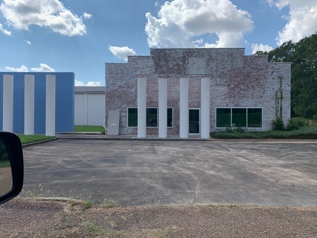

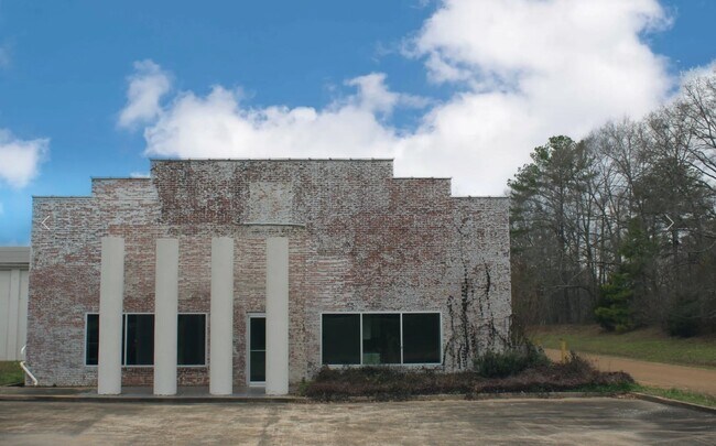
Property Detail
243 Flowood Dr
D08Q-000029-00030
7.34 A IN NW4 NE4
Warehouse
RANKIN
C and X Area of minimal flood hazard, usually depicted on FIRMs as above the 500-year flood level.
Mississippi
2024
7.34 AC
2025
Brandon/Flowood/Pearl
020304
Jackson
10,260 SF
Jackson, MS
NEARBY LISTINGS FOR SALE OR LEASE
DEMOGRAPHICS near 243 Flowood Dr
1 mile
3 mile
5 mile
2025 Total Population
1,381
21,168
70,829
2030 Population
1,430
21,204
70,930
Pop Growth 2025-2030
+ 3.55%
+ 0.17%
+ 0.14%
Average Age
38
39
39
2025 Total Households
562
9,218
28,946
HH Growth 2025-2030
+ 3.74%
(0.25%)
+ 0.03%
Median Household Inc
$37,013
$47,139
$42,715
Avg Household Size
2.30
2.20
2.20
2025 Avg HH Vehicles
2.00
2.00
2.00
Median Home Value
$177,152
$164,057
$150,756
Median Year Built
1968
1972
1968
Nearby Places
Map Layers
Map Styles
 Street
 Aerial
Transit
 Traffic
 Biking
Places
Listings with unknown addresses are not visible on the map
- Restaurants
- Banks
- Shops
- Fitness
- Groceries
PUBLIC TRANSPORTATION
COMMUTER RAIL
Jackson (City of New Orleans - Amtrak)
Drive
Walk
Distance
Jackson (City of New Orleans - Amtrak)
8 min
4.5 mi
AIRPORT
Jackson-Medgar Wiley Evers International
Drive
Walk
Distance
Jackson-Medgar Wiley Evers International
14 min
6.6 mi
Freight Ports
Port of Greater Baton Rouge
Drive
Walk
Distance
Port of Greater Baton Rouge
198 min
177.7 mi
SALE & LEASE HISTORY
LISTING DATE
SALE/LEASE

Jun 06, 2024
For Sale
Feb 27, 2024
For Lease
Feb 02, 2023
For Lease
Feb 02, 2023
For Sale
Nearby Properties
Address
Land Use
TOTAL SIZE
Lot Size
Zoning
Address
Land Use
TOTAL SIZE
Lot Size
Zoning
435,199 SF
1 AC
Address
Land Use
TOTAL SIZE
Lot Size
Zoning
74,923 SF
0.01 AC
Address
Land Use
TOTAL SIZE
Lot Size
Zoning
9,650 SF
0.55 AC
Address
Land Use
TOTAL SIZE
Lot Size
Zoning
7.60 AC
Address
Land Use
TOTAL SIZE
Lot Size
Zoning
Address
Land Use
TOTAL SIZE
Lot Size
Zoning
206,400 SF
7.96 AC
Address
Land Use
TOTAL SIZE
Lot Size
Zoning
413,174 SF
2 AC
Address
Land Use
TOTAL SIZE
Lot Size
Zoning
96,444 SF
0.88 AC
Address
Land Use
TOTAL SIZE
Lot Size
Zoning
94.48 AC
Address
Land Use
TOTAL SIZE
Lot Size
Zoning
62.33 AC
Address
Land Use
TOTAL SIZE
Lot Size
Zoning
247,574 SF
0.94 AC
Address
Land Use
TOTAL SIZE
Lot Size
Zoning
115,200 SF
0.35 AC
Address
Land Use
TOTAL SIZE
Lot Size
Zoning
17,261 SF
18.20 AC
Address
Land Use
TOTAL SIZE
Lot Size
Zoning
46,958 SF
0.77 AC
Address
Land Use
TOTAL SIZE
Lot Size
Zoning
31,541 SF
4 AC
Address
Land Use
TOTAL SIZE
Lot Size
Zoning
30,925 SF
38.73 AC
Address
Land Use
TOTAL SIZE
Lot Size
Zoning
2,190,610 SF
2 AC
Address
Land Use
TOTAL SIZE
Lot Size
Zoning
47,885 SF
0.01 AC
Address
Land Use
TOTAL SIZE
Lot Size
Zoning
69,034 SF
0.64 AC
Address
Land Use
TOTAL SIZE
Lot Size
Zoning
40,148 SF
37.47 AC
Address
Land Use
TOTAL SIZE
Lot Size
Zoning
9,081 SF
0.73 AC
Address
Land Use
TOTAL SIZE
Lot Size
Zoning
55,591 SF
1 AC
Address
Land Use
TOTAL SIZE
Lot Size
Zoning
42,520 SF
0.22 AC
Address
Land Use
TOTAL SIZE
Lot Size
Zoning
0.01 AC
Address
Land Use
TOTAL SIZE
Lot Size
Zoning
Address
Land Use
TOTAL SIZE
Lot Size
Zoning
38,189 SF
1 AC
Address
Land Use
TOTAL SIZE
Lot Size
Zoning
28.60 AC
Address
Land Use
TOTAL SIZE
Lot Size
Zoning
Address
Land Use
TOTAL SIZE
Lot Size
Zoning
2,348 SF
16.45 AC
Address
Land Use
TOTAL SIZE
Lot Size
Zoning
1,257 SF
2.65 AC
The World's #1 Commercial Real Estate Marketplace
Connect with us
© 2026 CoStar Group
The information above has been obtained from sources believed reliable. While we do not doubt its accuracy we have not verified it and make no guarantee, warranty or representation about it. It is your responsibility to independently confirm its accuracy and completeness. Any projections, opinions, assumptions, or estimates used are for example only and do not represent the current or future performance of the property. The value of this transaction to you depends on tax and other factors which should be evaluated by your tax, financial, and legal advisors. You and your advisors should conduct a careful, independent investigation of the property to determine to your satisfaction the suitability of the property for your needs.