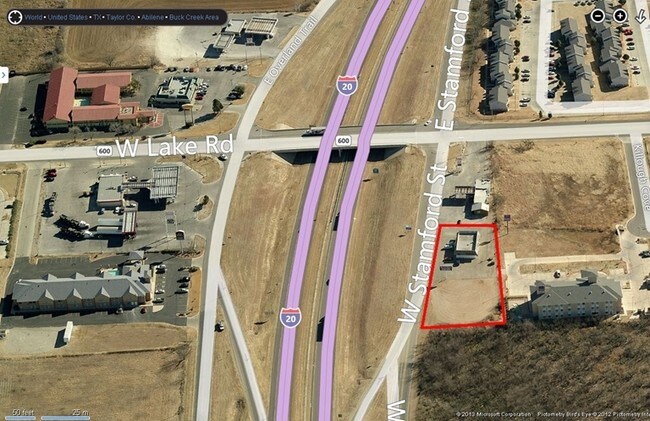
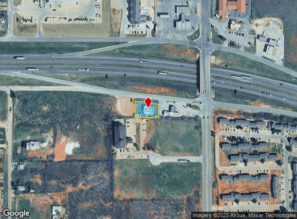
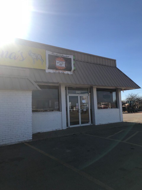
Property Record
243 W Stamford St, Abilene, TX 79601
NEARBY LISTINGS FOR SALE OR LEASE
Property Detail
243 W Stamford St
Abilene, TX
Adrian Subdivision
26734
ADRIAN SUBDIVISION, BLOCK 1, LOT W161 E411 OF 1
Multipleuses
Taylor
X
Texas
48441C0226F
w161
2024
0.37 AC
2025
North College
010200
Other Market Areas
3,512 SF
DEMOGRAPHICS near 243 W Stamford St
1 Mile
3 Mile
5 Mile
2024 Total Population
2,956
34,843
69,788
2029 Population
3,065
36,025
71,972
Pop Growth 2024-2029
+ 3.69%
+ 3.39%
+ 3.13%
Average Age
33
35
36
2024 Total Households
1,028
12,687
26,027
HH Growth 2024-2029
+ 3.89%
+ 3.62%
+ 3.34%
Median Household Inc
$35,536
$42,282
$45,778
Avg Household Size
2.40
2.40
2.40
2024 Avg HH Vehicles
2.00
2.00
2.00
Median Home Value
$143,351
$110,816
$122,124
Median Year Built
1974
1966
1959
Nearby Places
Map Layers
Map Styles
 Street
 Aerial
- Restaurants
- Banks
- Shops
- Fitness
- Groceries
PUBLIC TRANSPORTATION
AIRPORT
Abilene Regional
DRIVE
WALK
Distance
Abilene Regional
14 min
7.5 mi
SALE & LEASE HISTORY
LISTING DATE
SALE/LEASE

Sep 25, 2016
For Lease
Sep 24, 2016
For Sale
May 11, 2018
For Lease
Dec 29, 2017
For Sale
Nearby Properties
Address
Land Use
TOTAL SIZE
Lot Size
Zoning
Address
Land Use
TOTAL SIZE
Lot Size
Zoning
959,214 SF
94.96 AC
Address
Land Use
TOTAL SIZE
Lot Size
Zoning
24.36 AC
Address
Land Use
TOTAL SIZE
Lot Size
Zoning
812,955 SF
99.27 AC
Address
Land Use
TOTAL SIZE
Lot Size
Zoning
169,821 SF
3.59 AC
Address
Land Use
TOTAL SIZE
Lot Size
Zoning
325,355 SF
9.83 AC
Address
Land Use
TOTAL SIZE
Lot Size
Zoning
141,777 SF
36.78 AC
Address
Land Use
TOTAL SIZE
Lot Size
Zoning
212,450 SF
9.43 AC
Address
Land Use
TOTAL SIZE
Lot Size
Zoning
108,121 SF
15 AC
Address
Land Use
TOTAL SIZE
Lot Size
Zoning
728,862 SF
102.37 AC
Address
Land Use
TOTAL SIZE
Lot Size
Zoning
144,349 SF
11.07 AC
Address
Land Use
TOTAL SIZE
Lot Size
Zoning
166,224 SF
8.79 AC
Address
Land Use
TOTAL SIZE
Lot Size
Zoning
229,988 SF
9.22 AC
Address
Land Use
TOTAL SIZE
Lot Size
Zoning
88,656 SF
4.14 AC
Address
Land Use
TOTAL SIZE
Lot Size
Zoning
342,750 SF
34.54 AC
Address
Land Use
TOTAL SIZE
Lot Size
Zoning
75,482 SF
137.60 AC
Address
Land Use
TOTAL SIZE
Lot Size
Zoning
2.63 AC
Address
Land Use
TOTAL SIZE
Lot Size
Zoning
52,028 SF
3.62 AC
Address
Land Use
TOTAL SIZE
Lot Size
Zoning
209,580 SF
20.94 AC
Address
Land Use
TOTAL SIZE
Lot Size
Zoning
62,823 SF
9.39 AC
Address
Land Use
TOTAL SIZE
Lot Size
Zoning
130,048 SF
8.22 AC
Address
Land Use
TOTAL SIZE
Lot Size
Zoning
60,944 SF
2.86 AC
Address
Land Use
TOTAL SIZE
Lot Size
Zoning
2.63 AC
Address
Land Use
TOTAL SIZE
Lot Size
Zoning
77,187 SF
3.58 AC
Address
Land Use
TOTAL SIZE
Lot Size
Zoning
42,509 SF
8.63 AC
Address
Land Use
TOTAL SIZE
Lot Size
Zoning
38,150 SF
3.52 AC
Address
Land Use
TOTAL SIZE
Lot Size
Zoning
54,844 SF
12.70 AC
Address
Land Use
TOTAL SIZE
Lot Size
Zoning
108,695 SF
4 AC
Address
Land Use
TOTAL SIZE
Lot Size
Zoning
67,823 SF
14.89 AC
Address
Land Use
TOTAL SIZE
Lot Size
Zoning
30,455 SF
5.41 AC
Address
Land Use
TOTAL SIZE
Lot Size
Zoning
76,998 SF
24.63 AC
The World's #1 Commercial Real Estate Marketplace
Connect with us
© 2026 CoStar Group
The information above has been obtained from sources believed reliable. While we do not doubt its accuracy we have not verified it and make no guarantee, warranty or representation about it. It is your responsibility to independently confirm its accuracy and completeness. Any projections, opinions, assumptions, or estimates used are for example only and do not represent the current or future performance of the property. The value of this transaction to you depends on tax and other factors which should be evaluated by your tax, financial, and legal advisors. You and your advisors should conduct a careful, independent investigation of the property to determine to your satisfaction the suitability of the property for your needs.